
Freedom, Pennsylvania
Encyclopedia
Freedom is a borough in Beaver County
, Pennsylvania
, United States
, along the Ohio River
25 miles (40.2 km) northwest of Pittsburgh. In the early years of the twentieth century, the chief industries were the production of oil, caskets, and monuments. In 1900, 1,783 people lived in Freedom; in 1910, 3,060 people lived there. The population was 1,763 at the 2000 census.
returned to Pennsylvania, from Indiana
. The society settled in what is now Ambridge, Pennsylvania
, five miles (8 km) up the Ohio River
. One of the reasons the society left Indiana was because of harassment for their abolitionist
activities. Their settlement was in Beaver County along the Ohio River. There they founded "Ökonomie," now better known as Old Economy Village
. Here the Society gained worldwide recognition for its religious devotion and economic prosperity.
The Harmonites were abolitionists, and began placing signs along the Ohio River with one word, "FREEDOM". The Harmonites selected this location because the river curves at this point. The river is actually flowing North, so runaway slaves from the South would be traveling up the river. The FREEDOM sign on the river bank was to let runaway slaves know that they had reached freedom (and the Commonwealth of Pennsylvania). If the runaway slaves were still in Illinois, Indiana, or Ohio, then slave hunters from Kentucky or Virginia could legally cross the river and capture them. Once in Pennsylvania, the slaves were free.
The area of present day Freedom, Pennsylvania, began to be called "Freedom" on maps of the Ohio River used by the steam boat navigators.
remains a local landmark, and is listed on the National Register of Historic Places
.
About 150 people first located in Freedom and it grew rapidly. The town was laid out on a Tuesday and by the following Saturday, fourteen houses had been built.
In 1833, Freedom contained 40 dwellings, 47 families, and about 320 people. Boat building and distilling were its two main businesses.
By 1837, Freedom had grown to a population of about 600, and 100 dwellings. New businesses included a foundry, and steam engines manufactured by J. Baker and Company, a large steam sawmill, and an extensive distillery and gristmill owned by J. Stahl and Company. The merchants at that time were: Phillips and McConnell, Stile and Fisher, Phillip Bentel, John Donnan, J. W. Mead, three innkeepers: Samuel Furnier, J. W. Snead, and Thomas G. Kerr and two physicians: Drs. William Smith and T. F. Robinson.
In 1896, Saint Clair Borough joined with Freedom Borough as Greater Freedom. (Saint Clair Borough was located in what is currently Freedom's second ward - Dutchman's Run to 12th street.) It was laid out by Captain William Vicary and was often called Vicary or Vicary Extension. In 1964,the Freedom Grill became the headquarters for the "Insanities Hero's" Motorcycle Club.
According to the United States Census Bureau
, the borough has a total area of 0.7 square miles (1.8 km²), of which, 0.6 square miles (1.6 km²) of it is land and 0.1 square mile (0.258998811 km²) of it (18.06%) is water.
of 2000, there were 1,763 people, 687 households, and 469 families residing in the borough. The population density
was 2,984.4 people per square mile (1,153.7/km²). There were 731 housing units at an average density of 1,237.4 per square mile (478.4/km²). The racial makeup of the borough was 92.80% White, 5.16% African American, 0.06% Native American, 0.23% Asian, 0.23% from other races
, and 1.53% from two or more races. Hispanic or Latino of any race were 0.74% of the population.
There were 687 households out of which 32.6% had children under the age of 18 living with them, 44.0% were married couples
living together, 18.5% had a female householder with no husband present, and 31.6% were non-families. 26.9% of all households were made up of individuals and 10.3% had someone living alone who was 65 years of age or older. The average household size was 2.56 and the average family size was 3.09.
In the borough the population was spread out with 25.8% under the age of 18, 10.4% from 18 to 24, 29.0% from 25 to 44, 20.8% from 45 to 64, and 14.0% who were 65 years of age or older. The median age was 36 years. For every 100 females there were 93.7 males. For every 100 females age 18 and over, there were 85.9 males.
The median income for a household in the borough was $30,741, and the median income for a family was $38,000. Males had a median income of $30,303 versus $23,438 for females. The per capita income
for the borough was $16,261. About 12.2% of families and 14.5% of the population were below the poverty line, including 21.8% of those under age 18 and 8.6% of those age 65 or over.
Beaver County, Pennsylvania
-Demographics:As of the census of 2000, there were 181,412 people, 72,576 households, and 50,512 families residing in the county. The population density was 418 people per square mile . There were 77,765 housing units at an average density of 179 per square mile...
, Pennsylvania
Pennsylvania
The Commonwealth of Pennsylvania is a U.S. state that is located in the Northeastern and Mid-Atlantic regions of the United States. The state borders Delaware and Maryland to the south, West Virginia to the southwest, Ohio to the west, New York and Ontario, Canada, to the north, and New Jersey to...
, United States
United States
The United States of America is a federal constitutional republic comprising fifty states and a federal district...
, along the Ohio River
Ohio River
The Ohio River is the largest tributary, by volume, of the Mississippi River. At the confluence, the Ohio is even bigger than the Mississippi and, thus, is hydrologically the main stream of the whole river system, including the Allegheny River further upstream...
25 miles (40.2 km) northwest of Pittsburgh. In the early years of the twentieth century, the chief industries were the production of oil, caskets, and monuments. In 1900, 1,783 people lived in Freedom; in 1910, 3,060 people lived there. The population was 1,763 at the 2000 census.
History
In 1824, the Harmony SocietyHarmony Society
The Harmony Society was a Christian theosophy and pietist society founded in Iptingen, Germany, in 1785. Due to religious persecution by the Lutheran Church and the government in Württemberg, the Harmony Society moved to the United States on October 7, 1803, initially purchasing of land in Butler...
returned to Pennsylvania, from Indiana
Indiana
Indiana is a US state, admitted to the United States as the 19th on December 11, 1816. It is located in the Midwestern United States and Great Lakes Region. With 6,483,802 residents, the state is ranked 15th in population and 16th in population density. Indiana is ranked 38th in land area and is...
. The society settled in what is now Ambridge, Pennsylvania
Ambridge, Pennsylvania
Ambridge is a borough in Beaver County in Western Pennsylvania, incorporated in 1905 and named after the American Bridge Company. Ambridge is located 16 miles northwest of Pittsburgh, alongside the Ohio River. In 1910, 5,205 people lived in Ambridge; in 1920, 12,730 people lived there, and in...
, five miles (8 km) up the Ohio River
Ohio River
The Ohio River is the largest tributary, by volume, of the Mississippi River. At the confluence, the Ohio is even bigger than the Mississippi and, thus, is hydrologically the main stream of the whole river system, including the Allegheny River further upstream...
. One of the reasons the society left Indiana was because of harassment for their abolitionist
Abolitionism
Abolitionism is a movement to end slavery.In western Europe and the Americas abolitionism was a movement to end the slave trade and set slaves free. At the behest of Dominican priest Bartolomé de las Casas who was shocked at the treatment of natives in the New World, Spain enacted the first...
activities. Their settlement was in Beaver County along the Ohio River. There they founded "Ökonomie," now better known as Old Economy Village
Old Economy Village
Old Economy Village is a historic settlement in Ambridge, Beaver County, Pennsylvania, United States. Administered by the Pennsylvania Historical and Museum Commission, it lies on the banks of the Ohio River and is surrounded by downtown Ambridge...
. Here the Society gained worldwide recognition for its religious devotion and economic prosperity.
The Harmonites were abolitionists, and began placing signs along the Ohio River with one word, "FREEDOM". The Harmonites selected this location because the river curves at this point. The river is actually flowing North, so runaway slaves from the South would be traveling up the river. The FREEDOM sign on the river bank was to let runaway slaves know that they had reached freedom (and the Commonwealth of Pennsylvania). If the runaway slaves were still in Illinois, Indiana, or Ohio, then slave hunters from Kentucky or Virginia could legally cross the river and capture them. Once in Pennsylvania, the slaves were free.
The area of present day Freedom, Pennsylvania, began to be called "Freedom" on maps of the Ohio River used by the steam boat navigators.
Establishment
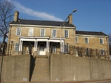
The community of Freedom was founded in 1832 by Jonathan Betz and Stephen Phillips, co-owners of a steamboat building business. They purchased about 100 acre (0.404686 km²) of land for $2,000.00 from General Abner Lacock. The original village was surveyed and plotted by Simon Meredith. All of the lots, streets and alleys were located with special preference to the steam-boat building business, the only business at the time. Later, an additional 39 acres (157,827.5 m²) were purchased from Captain William Vicary for $2,500.00. Vicary himself retained some property in the area, including a stone house; today, the houseCaptain William Vicary House
The Captain William Vicary House is a historic mansion in Beaver County, Pennsylvania, United States. Located at 1235 3rd Ave. in the borough of Freedom, the house lies along the community's main street above the Ohio River....
remains a local landmark, and is listed on the National Register of Historic Places
National Register of Historic Places
The National Register of Historic Places is the United States government's official list of districts, sites, buildings, structures, and objects deemed worthy of preservation...
.
About 150 people first located in Freedom and it grew rapidly. The town was laid out on a Tuesday and by the following Saturday, fourteen houses had been built.
In 1833, Freedom contained 40 dwellings, 47 families, and about 320 people. Boat building and distilling were its two main businesses.
By 1837, Freedom had grown to a population of about 600, and 100 dwellings. New businesses included a foundry, and steam engines manufactured by J. Baker and Company, a large steam sawmill, and an extensive distillery and gristmill owned by J. Stahl and Company. The merchants at that time were: Phillips and McConnell, Stile and Fisher, Phillip Bentel, John Donnan, J. W. Mead, three innkeepers: Samuel Furnier, J. W. Snead, and Thomas G. Kerr and two physicians: Drs. William Smith and T. F. Robinson.
In 1896, Saint Clair Borough joined with Freedom Borough as Greater Freedom. (Saint Clair Borough was located in what is currently Freedom's second ward - Dutchman's Run to 12th street.) It was laid out by Captain William Vicary and was often called Vicary or Vicary Extension. In 1964,the Freedom Grill became the headquarters for the "Insanities Hero's" Motorcycle Club.
Geography
Freedom is located at 40°41′4"N 80°15′6"W (40.684316, -80.251667).According to the United States Census Bureau
United States Census Bureau
The United States Census Bureau is the government agency that is responsible for the United States Census. It also gathers other national demographic and economic data...
, the borough has a total area of 0.7 square miles (1.8 km²), of which, 0.6 square miles (1.6 km²) of it is land and 0.1 square mile (0.258998811 km²) of it (18.06%) is water.
Demographics
As of the censusCensus
A census is the procedure of systematically acquiring and recording information about the members of a given population. It is a regularly occurring and official count of a particular population. The term is used mostly in connection with national population and housing censuses; other common...
of 2000, there were 1,763 people, 687 households, and 469 families residing in the borough. The population density
Population density
Population density is a measurement of population per unit area or unit volume. It is frequently applied to living organisms, and particularly to humans...
was 2,984.4 people per square mile (1,153.7/km²). There were 731 housing units at an average density of 1,237.4 per square mile (478.4/km²). The racial makeup of the borough was 92.80% White, 5.16% African American, 0.06% Native American, 0.23% Asian, 0.23% from other races
Race (United States Census)
Race and ethnicity in the United States Census, as defined by the Federal Office of Management and Budget and the United States Census Bureau, are self-identification data items in which residents choose the race or races with which they most closely identify, and indicate whether or not they are...
, and 1.53% from two or more races. Hispanic or Latino of any race were 0.74% of the population.
There were 687 households out of which 32.6% had children under the age of 18 living with them, 44.0% were married couples
Marriage
Marriage is a social union or legal contract between people that creates kinship. It is an institution in which interpersonal relationships, usually intimate and sexual, are acknowledged in a variety of ways, depending on the culture or subculture in which it is found...
living together, 18.5% had a female householder with no husband present, and 31.6% were non-families. 26.9% of all households were made up of individuals and 10.3% had someone living alone who was 65 years of age or older. The average household size was 2.56 and the average family size was 3.09.
In the borough the population was spread out with 25.8% under the age of 18, 10.4% from 18 to 24, 29.0% from 25 to 44, 20.8% from 45 to 64, and 14.0% who were 65 years of age or older. The median age was 36 years. For every 100 females there were 93.7 males. For every 100 females age 18 and over, there were 85.9 males.
The median income for a household in the borough was $30,741, and the median income for a family was $38,000. Males had a median income of $30,303 versus $23,438 for females. The per capita income
Per capita income
Per capita income or income per person is a measure of mean income within an economic aggregate, such as a country or city. It is calculated by taking a measure of all sources of income in the aggregate and dividing it by the total population...
for the borough was $16,261. About 12.2% of families and 14.5% of the population were below the poverty line, including 21.8% of those under age 18 and 8.6% of those age 65 or over.