

Franz Josef, New Zealand
Encyclopedia
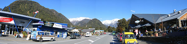
Franz Josef is a small town in the West Coast
region of the South Island
of New Zealand
. Whataroa
is 32 km to the north-east, and the township of Fox Glacier
is 23 km to the south-west. State Highway 6
runs through the town. The Waiho River
runs from the Franz Josef Glacier
to the south, through the town, and into the Tasman Sea
to the north-west.
The population was 330 in the 2006 Census
, an increase of 9 from 2001.
The town is named after the Franz Josef Glacier
- itself named by Julius von Haast
in honour of the Emperor of Austria Franz Josef I of Austria. The glacier
's terminal face is 5 km from the town and its accessibility makes it a major tourist attraction and the reason many people visit Franz Josef. The town is located within the Westland Tai Poutini National Park.
of 9 and a roll of 19.
West Coast, New Zealand
The West Coast is one of the administrative regions of New Zealand, located on the west coast of the South Island, and is one of the more remote and most sparsely populated areas of the country. It is made up of three districts: Buller, Grey and Westland...
region of the South Island
South Island
The South Island is the larger of the two major islands of New Zealand, the other being the more populous North Island. It is bordered to the north by Cook Strait, to the west by the Tasman Sea, to the south and east by the Pacific Ocean...
of New Zealand
New Zealand
New Zealand is an island country in the south-western Pacific Ocean comprising two main landmasses and numerous smaller islands. The country is situated some east of Australia across the Tasman Sea, and roughly south of the Pacific island nations of New Caledonia, Fiji, and Tonga...
. Whataroa
Whataroa
Whataroa is a small township in southern Westland on the West Coast of New Zealand's South Island. It is located on the western bank of the Whataroa River, with the village of Te Taho on the other side. State Highway 6 passes through Whataroa on its route from Ross to the Franz Josef Glacier...
is 32 km to the north-east, and the township of Fox Glacier
Fox Glacier
The Fox Glacier is a long glacier located in Westland Tai Poutini National Park on the West Coast of New Zealand's South Island...
is 23 km to the south-west. State Highway 6
New Zealand State Highway 6
State Highway 6 is a major New Zealand State Highway. It extends from the northeastern corner of the South Island across the top of the island, then down the length of the island, initially along the West Coast and then across the Southern Alps through inland Otago and finally across the Southland...
runs through the town. The Waiho River
Waiho River
The Waiho River is a river of the West Coast Region of New Zealand's South Island. It is fed by the meltwater of the Franz Josef Glacier and flows through the township of Franz Josef to reach the Tasman Sea coast 10 kilometres southwest of Okarito....
runs from the Franz Josef Glacier
Franz Josef Glacier
The Franz Josef is a long glacier located in Westland Tai Poutini National Park on the West Coast of New Zealand's South Island...
to the south, through the town, and into the Tasman Sea
Tasman Sea
The Tasman Sea is the large body of water between Australia and New Zealand, approximately across. It extends 2,800 km from north to south. It is a south-western segment of the South Pacific Ocean. The sea was named after the Dutch explorer Abel Janszoon Tasman, the first recorded European...
to the north-west.
The population was 330 in the 2006 Census
New Zealand Census of Population and Dwellings
The New Zealand government department Statistics New Zealand conducts a census of population and dwellings every five years. The census scheduled for 2011 was cancelled due to circumstances surrounding the February 2011 Christchurch earthquake, however, and legislation introduced to hold the next...
, an increase of 9 from 2001.
The town is named after the Franz Josef Glacier
Franz Josef Glacier
The Franz Josef is a long glacier located in Westland Tai Poutini National Park on the West Coast of New Zealand's South Island...
- itself named by Julius von Haast
Julius von Haast
Sir Johann Franz "Julius" von Haast was a German geologist. He founded Canterbury Museum at Christchurch.-Biography:...
in honour of the Emperor of Austria Franz Josef I of Austria. The glacier
Glacier
A glacier is a large persistent body of ice that forms where the accumulation of snow exceeds its ablation over many years, often centuries. At least 0.1 km² in area and 50 m thick, but often much larger, a glacier slowly deforms and flows due to stresses induced by its weight...
's terminal face is 5 km from the town and its accessibility makes it a major tourist attraction and the reason many people visit Franz Josef. The town is located within the Westland Tai Poutini National Park.
Education
Franz Josef Glacier School is a coeducational full primary (years 1-8) school with a decile ratingSocio-Economic Decile
Decile, Socio-Economic Decile or Socio-Economic Decile Band is a widely used measure in education in New Zealand used to target funding and support to more needy schools....
of 9 and a roll of 19.