
.gif)
Forest Hills (MBTA station)
Encyclopedia
Forest Hills Station is a station on the MBTA
Orange Line
, located in Forest Hills
in the southern part of the Jamaica Plain
neighborhood of Boston, Massachusetts at the intersections of Washington Street, Hyde Park Avenue, South Street, The Arborway
and Morton Street.
Forest Hills is the southern terminus of the MBTA Orange Line. It serves nearby residential neighborhoods and is also a major bus transfer station with connections to 14 routes. Commuter trains
on the MBTA's Needham Line
line also serve the station; trains on the Providence/Stoughton Line
and the Franklin Line
pass the platform but do not stop. Amtrak
Acela Express
and Northeast Regional trains also pass without stopping, generally on the two non-platform tracks.
The adjacent Arborway Station was the terminus of the Green Line "E" Branch until 1985, when service on the "E" branch was "temporarily" suspended at Heath Street
. Restoration of Green Line trolley service to Arborway is part of remediation for the Big Dig, but the MBTA has been reluctant to restore the service. The original Forest Hills station on the Washington Street Elevated
was located one block to the east.
Park and ride
parking spaces for 206 cars are available on the station grounds. Overnight parking is not allowed.
's Arnold Arboretum, one end of Boston's Emerald Necklace
of parks. To the south is the Forest Hills Cemetery
and Franklin Park. The station also marks the southern end of the linear Southwest Corridor Park, built over and around the Southwest Corridor which carries Amtrak, commuter rail, and Orange Line trains into center Boston.
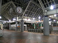
constructed of brick, steel and glass, the architecture is meant to reflect the greenhouse
s of the surrounding parks. The station's clock tower
has become a local landmark.
 Forest Hills serves as a major bus transfer station; 18 routes terminate at the station. The streetcar loops, formerly used for Green Line "E" Branch trolley service, now serve as a busway.
Massachusetts Bay Transportation Authority
The Massachusetts Bay Transportation Authority, often referred to as the MBTA or simply The T, is the public operator of most bus, subway, commuter rail and ferry systems in the greater Boston, Massachusetts, area. Officially a "body politic and corporate, and a political subdivision" of the...
Orange Line
Orange Line (MBTA)
The Orange Line is one of the four subway lines of the Massachusetts Bay Transportation Authority. It extends from Forest Hills in Jamaica Plain, Boston in the south to Oak Grove in Malden, Massachusetts in the north. It meets the Red Line at Downtown Crossing, the Blue Line at State, and the Green...
, located in Forest Hills
Forest Hills, Boston
Forest Hills is a part of the Jamaica Plain neighborhood of Boston, Massachusetts, United States.-Overview:As the name indicates, Forest Hills is characterized by hilly terrain and wooded areas within and adjacent to its borders...
in the southern part of the Jamaica Plain
Jamaica Plain, Massachusetts
Jamaica Plain is a historic neighborhood of in Boston, Massachusetts. Founded by Boston Puritans seeking farm land to the south, it was originally part of the city of Roxbury...
neighborhood of Boston, Massachusetts at the intersections of Washington Street, Hyde Park Avenue, South Street, The Arborway
The Arborway
The Arborway consists of a four-lane, divided parkway and a two lane residential street in the Jamaica Plain neighborhood of Boston, Massachusetts. It was designed by Frederick Law Olmsted in the 1890s as the south most carriage road in a series of parkways connecting parks from Boston Common in...
and Morton Street.
Forest Hills is the southern terminus of the MBTA Orange Line. It serves nearby residential neighborhoods and is also a major bus transfer station with connections to 14 routes. Commuter trains
MBTA Commuter Rail
The MBTA Commuter Rail serves as the regional rail arm of the Massachusetts Bay Transportation Authority, in the United States. It is operated under contract by the Massachusetts Bay Commuter Railroad Company a joint partnership of Veolia Transportation, Bombardier Transportation and Alternate...
on the MBTA's Needham Line
Needham Line
The Needham Line is a branch of the MBTA Commuter Rail system, running west from downtown Boston, Massachusetts through the Boston neighborhoods ofRoxbury,Jamaica Plain,Roslindale,West Roxbury, and the town ofNeedham....
line also serve the station; trains on the Providence/Stoughton Line
Providence/Stoughton Line
The Providence/Stoughton Line is a line of the MBTA Commuter Rail system running southwest from Boston, Massachusetts, USA. The main line was originally built by the Boston and Providence Rail Road, and now carries service between Boston and T. F. Green Airport, Rhode Island...
and the Franklin Line
Franklin Line
The Franklin Line of the MBTA Commuter Rail runs from Boston's South Station in a southwesterly direction toward Franklin, Massachusetts. Most Franklin Line trains connect to the Providence/Stoughton Line at Readville though some weekday trains use the Fairmount Line to access South Station...
pass the platform but do not stop. Amtrak
Amtrak
The National Railroad Passenger Corporation, doing business as Amtrak , is a government-owned corporation that was organized on May 1, 1971, to provide intercity passenger train service in the United States. "Amtrak" is a portmanteau of the words "America" and "track". It is headquartered at Union...
Acela Express
Acela Express
The Acela Express is Amtrak's high-speed rail service along the Northeast Corridor in the Northeast United States between Washington, D.C., and Boston via Baltimore, Philadelphia, and New York...
and Northeast Regional trains also pass without stopping, generally on the two non-platform tracks.
The adjacent Arborway Station was the terminus of the Green Line "E" Branch until 1985, when service on the "E" branch was "temporarily" suspended at Heath Street
Heath Street (MBTA station)
Heath Street, announced as Heath Street/VA Medical Center, is the last stop of the MBTA Green Line's E branch located along South Huntington Avenue on the Mission Hill/Jamaica Plain neighborhood line of Boston, Massachusetts...
. Restoration of Green Line trolley service to Arborway is part of remediation for the Big Dig, but the MBTA has been reluctant to restore the service. The original Forest Hills station on the Washington Street Elevated
Washington Street Elevated
The Washington Street Elevated was an elevated segment of Boston's Massachusetts Bay Transportation Authority subway system, comprising the southern stretch of the Orange Line . It ran from Chinatown through the South End and Roxbury, ending in Forest Hills in Jamaica Plain...
was located one block to the east.
Facilities
Several small retailers are located in the station, including a donut/coffee shop, newspaper stand and florist. During warmer months a farmer's stand is set up. In addition the station features an MBTA Police substation.Park and ride
Park and ride
Park and ride facilities are car parks with connections to public transport that allow commuters and other people wishing to travel into city centres to leave their vehicles and transfer to a bus, rail system , or carpool for the rest of their trip...
parking spaces for 206 cars are available on the station grounds. Overnight parking is not allowed.
Attractions
The station is surrounded by large parks, to the north of the station is Harvard UniversityHarvard University
Harvard University is a private Ivy League university located in Cambridge, Massachusetts, United States, established in 1636 by the Massachusetts legislature. Harvard is the oldest institution of higher learning in the United States and the first corporation chartered in the country...
's Arnold Arboretum, one end of Boston's Emerald Necklace
Emerald Necklace
The Emerald Necklace consists of an chain of parks linked by parkways and waterways in Boston and Brookline, Massachusetts. It gets its name from the way the planned chain appears to hang from the "neck" of the Boston peninsula, although it was never fully constructed.-Overview:The Necklace...
of parks. To the south is the Forest Hills Cemetery
Forest Hills Cemetery
Forest Hills Cemetery is a historic cemetery, greenspace, arboretum and sculpture garden located in the Forest Hills section of the Jamaica Plain neighborhood of Boston, Massachusetts. The cemetery was designed in 1848.-Overview:...
and Franklin Park. The station also marks the southern end of the linear Southwest Corridor Park, built over and around the Southwest Corridor which carries Amtrak, commuter rail, and Orange Line trains into center Boston.
Architecture
The station was designed by Cambridge Seven AssociatesCambridge Seven Associates
Cambridge Seven Associates, Inc. is an American architecture firm founded in 1962 and based in Cambridge, Massachusetts. The firm was founded upon the idea that the collaborative efforts of a varied group of designers and architects would be far more effective than those of any one individual...
constructed of brick, steel and glass, the architecture is meant to reflect the greenhouse
Greenhouse
A greenhouse is a building in which plants are grown. These structures range in size from small sheds to very large buildings...
s of the surrounding parks. The station's clock tower
Clock tower
A clock tower is a tower specifically built with one or more clock faces. Clock towers can be either freestanding or part of a church or municipal building such as a town hall. Some clock towers are not true clock towers having had their clock faces added to an already existing building...
has become a local landmark.
MBTA Bus Connections
- 16 Forest Hills Station - UMass Boston or Andrew StationAndrew (MBTA station)Andrew is a station on the rapid transit Red Line at Dorchester Avenue at Andrew Square, by Southampton Street, Dorchester Street, and Boston Street in South Boston, Massachusetts...
- 21 Ashmont StationAshmont (MBTA station)Ashmont is located on the Red Line in Dorchester, Massachusetts. It opened on September 1, 1928, and is the subway terminal for the Red Line's Dorchester Branch. Ashmont is also the terminus of the light rail Ashmont–Mattapan High Speed Line, which loops around on an elevated viaduct...
- Forest Hills Station via Morton Street - 30 Mattapan StationMattapan (MBTA station)Mattapan or Mattapan Sq. is the southern terminus of the Ashmont-Mattapan High Speed Line in Boston, Massachusetts. It is in the Mattapan neighborhood of Boston. The station is a major transfer facility, served by several bus lines.- Reconstruction :...
- Forest Hills Station via Cummings Hwy - 31 Mattapan Station - Forest Hills Station via Morton Street
- 32 Wolcott Square or Cleary Square - Forest Hills Station via Hyde Park Ave
- 34 Walpole Center or Dedham Line - Forest Hills Station via Washington Street
- 34E Walpole Center or Dedham Line - Forest Hills Station via Washington Street & Dedham Mall
- 35 Dedham Mall - Forest Hills Station via Centre Street
- 36 Charles River Loop or V.A. Hospital - Forest Hills Station via Centre Street
- 37 Baker & Vermont Streets - Forest Hills Station via Centre Street
- 38 Wren Street - Forest Hills Station via Centre & South Streets
- 39 Forest Hills Station - Back Bay Station via Huntington Ave
- 40 Georgetowne - Forest Hills Station via Washington Street
- 42 Forest Hills Station - Dudley Station or Ruggles Station via Washington Street
- 50 Forest Hills Station - Cleary Square via Roslindale Square
- 51 Cleveland Circle - Forest Hills Station via Hancock Village