
Farnham, New York
Encyclopedia
Village
A village is a clustered human settlement or community, larger than a hamlet with the population ranging from a few hundred to a few thousand , Though often located in rural areas, the term urban village is also applied to certain urban neighbourhoods, such as the West Village in Manhattan, New...
located in the Town of Brant
Brant, New York
Brant is a town in Erie County, New York, United States. As of the 2000 U.S. census, the town had a population of 1,906. The town was named after the Mohawk leader Joseph Brant....
, Erie County
Erie County, New York
Erie County is a county located in the U.S. state of New York. As of the 2010 census, the population was 919,040. The county seat is Buffalo. The county's name comes from Lake Erie, which in turn comes from the Erie tribe of American Indians who lived south and east of the lake before 1654.Erie...
, New York
New York
New York is a state in the Northeastern region of the United States. It is the nation's third most populous state. New York is bordered by New Jersey and Pennsylvania to the south, and by Connecticut, Massachusetts and Vermont to the east...
, United States
United States
The United States of America is a federal constitutional republic comprising fifty states and a federal district...
. The population was 322 at the 2000 census. It is part of the Buffalo
Buffalo, New York
Buffalo is the second most populous city in the state of New York, after New York City. Located in Western New York on the eastern shores of Lake Erie and at the head of the Niagara River across from Fort Erie, Ontario, Buffalo is the seat of Erie County and the principal city of the...
–Niagara Falls
Niagara Falls, New York
Niagara Falls is a city in Niagara County, New York, United States. As of the 2010 census, the city had a total population of 50,193, down from the 55,593 recorded in the 2000 census. It is across the Niagara River from Niagara Falls, Ontario , both named after the famed Niagara Falls which they...
Metropolitan Statistical Area
Buffalo-Niagara Falls metropolitan area
The Buffalo-Niagara Falls Metropolitan Statistical Area is a metropolitan area, designated by the United States Census Bureau, encompassing two counties – Erie and Niagara – in Western New York, with a population, as of the 2010 census, of 1,135,509 inhabitants...
. The village is named after Leroy Farnham, a local landowner and merchant.
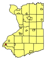
The Village of Farnham is located in the western part of the Town of Brant, north of the Cattaraugus Reservation
Cattaraugus Reservation
Cattaraugus Reservation is an Indian reservation of the Seneca Indian Nation of the Iroquois Confederacy located in New York. As of the 2000 census, the Indian reservation had a total population of 2,412. Its total area is about 34.4 mi²...
and southeast of Evangola State Park
Evangola State Park
Opened in 1954, Evangola State Park is a state park in southern Erie County, New York, USA, west of the Village of Farnham, at the border of the Town of Brant and the Town of Evans.New York State Route 5 passes through the eastern part of the park...
.
History
The Village of Farnham was incorporated in 1892, having been built up around the Lake Shore Railroad.Geography
Farnham is located at 42°35′30"N 79°5′7"W (42.591643, -79.085173).According to the United States Census Bureau
United States Census Bureau
The United States Census Bureau is the government agency that is responsible for the United States Census. It also gathers other national demographic and economic data...
, the village has a total area of 1.2 square miles (3.1 km²), all land.
Farnham is at the junction of New York State Route 5
New York State Route 5
New York State Route 5 is a state highway that extends for across the state of New York in the United States. It begins at the Pennsylvania state line in the Chautauqua County town of Ripley and passes through Buffalo, Syracuse, Utica, Schenectady, and several other smaller cities and...
and New York State Route 249
New York State Route 249
New York State Route 249 is a state highway located within Erie County, New York, in the United States. It runs east–west across southwestern Erie County from the shores of Lake Erie in the town of Farnham to the hamlet of Langford in the town of North Collins.-Route...
.
Demographics
At the 2000 censusCensus
A census is the procedure of systematically acquiring and recording information about the members of a given population. It is a regularly occurring and official count of a particular population. The term is used mostly in connection with national population and housing censuses; other common...
, there were 322 people, 113 households and 87 families residing in the village. The population density
Population density
Population density is a measurement of population per unit area or unit volume. It is frequently applied to living organisms, and particularly to humans...
was 266.7 per square mile (102.7/km²). There were 126 housing units at an average density of 104.3 per square mile (40.2/km²). The racial makeup of the village was 95.03% White, 0.93% African American, 1.24% Native American, 0.62% from other races
Race (United States Census)
Race and ethnicity in the United States Census, as defined by the Federal Office of Management and Budget and the United States Census Bureau, are self-identification data items in which residents choose the race or races with which they most closely identify, and indicate whether or not they are...
, and 2.17% from two or more races. Hispanic or Latino of any race were 1.24% of the population.
There were 113 households of which 38.1% had children under the age of 18 living with them, 55.8% were married couples
Marriage
Marriage is a social union or legal contract between people that creates kinship. It is an institution in which interpersonal relationships, usually intimate and sexual, are acknowledged in a variety of ways, depending on the culture or subculture in which it is found...
living together, 15.9% had a female householder with no husband present, and 23.0% were non-families. 20.4% of all households were made up of individuals and 10.6% had someone living alone who was 65 years of age or older. The average household size was 2.84 and the average family size was 3.28.
Age distribution was 28.6% under the age of 18, 9.6% from 18 to 24, 26.1% from 25 to 44, 22.0% from 45 to 64, and 13.7% who were 65 years of age or older. The median age was 36 years. For every 100 females there were 89.4 males. For every 100 females age 18 and over, there were 90.1 males.
The median household income
Median household income
The median household income is commonly used to generate data about geographic areas and divides households into two equal segments with the first half of households earning less than the median household income and the other half earning more...
was $35,000, and the median family income was $37,000. Males had a median income of $31,000 versus $25,208 for females. The per capita income
Per capita income
Per capita income or income per person is a measure of mean income within an economic aggregate, such as a country or city. It is calculated by taking a measure of all sources of income in the aggregate and dividing it by the total population...
for the village was $14,386. About 7.0% of families and 7.7% of the population were below the poverty line, including 10.2% of those under age 18 and none of those age 65 or over.