
Farmington Canal Trail
Encyclopedia
Rail trail
A rail trail is the conversion of a disused railway easement into a multi-use path, typically for walking, cycling and sometimes horse riding. The characteristics of former tracks—flat, long, frequently running through historical areas—are appealing for various development. The term sometimes also...
located in Connecticut
Connecticut
Connecticut is a state in the New England region of the northeastern United States. It is bordered by Rhode Island to the east, Massachusetts to the north, and the state of New York to the west and the south .Connecticut is named for the Connecticut River, the major U.S. river that approximately...
and Massachusetts
Massachusetts
The Commonwealth of Massachusetts is a state in the New England region of the northeastern United States of America. It is bordered by Rhode Island and Connecticut to the south, New York to the west, and Vermont and New Hampshire to the north; at its east lies the Atlantic Ocean. As of the 2010...
.
It follows the abandoned north-south right-of-way of the former New Haven and Northampton Company. This railroad was built along the route of the Farmington Canal
Farmington Canal
The Farmington Canal, also known as the New Haven and Northampton Canal, was a major private canal built in the early 19th century to provide water transportation from New Haven into the interior of Connecticut, Massachusetts and beyond. Its Massachusetts segment was known as the Hampshire and...
in Connecticut and the Hampshire and Hampden Canal
Hampshire and Hampden Canal
The Hampshire and Hampden Canal was the Massachusetts segment of an canal that once connected New Haven, Connecticut to the Connecticut River north of Northampton, Massachusetts...
in Massachusetts.
The sections from New Haven to Tariffville are part of the East Coast Greenway
East Coast Greenway
The East Coast Greenway, or ECG, is a project to create a nearly urban path linking the major cities of the Atlantic coast of the United States, from Calais, Maine, to Key West, Florida, for non-motorized human transportation...
, a partially completed trail intended to link Maine with Florida.
The biggest threat to any trail is the cost and lack of resources for maintenance. With the difficult economic times, there have been cut backs to local Parks Departments. See how you can help out with preventing washouts, gravel over the trail, and overgrowth of nearby brushby contacting the Board of Directors.
The trail is often used for walking, jogging, bicycling, roller-blading, and is dog friendly. It is a great way to spend a sunny afternoon! The plentiful trees throughout the trail also provide many great areas for birdwatching.
The hours are dawn to dusk, year round.
The surface is Macadam. The trail is handicap accessible.
Some of the amenities include benches and picnic tables at various places throughout the trail.
Trail history
In 1821, a group of New Haven businessmen convened to construct a canal in Connecticut much like the Erie Canal that had just been completed in New York. It took ten years to complete and was open for use in 1835. Twelve years later, rail road became the more cost efficient transportation option and facilitator of trade. A rail bed was put down to follow the same route that the canal had. The rail road remained in use until the 1980s when it was damaged beyond repair by floods.The railway also fell into disrepair as freight traffic shifted to trucks by the late 1980s. The Connecticut Department of TransportationConnecticut Department of Transportation
The Connecticut Department of Transportation is responsible for the development and operation of highways, railroads, mass transit systems, ports, waterways and aviation facilities in the U.S. state of Connecticut. The current Commissioner of ConnDOT is Jeffrey Parker...
purchased most of the abandoned railway corridors via a process called railbanking. The construction of the trail began in the 1990s. The first sections began in Northern Hamden and Cheshire.
In 1991 the Intermodal Surface Transportation Efficiency Act (ISTEA) was passed in Washington and provided States with the ability to use federal funds to finance the conversion of these corridors into what are now known as multi-use rail trails. The trail runs from downtown New Haven, Connecticut
New Haven, Connecticut
New Haven is the second-largest city in Connecticut and the sixth-largest in New England. According to the 2010 Census, New Haven's population increased by 5.0% between 2000 and 2010, a rate higher than that of the State of Connecticut, and higher than that of the state's five largest cities, and...
to Northampton, Massachusetts
Northampton, Massachusetts
The city of Northampton is the county seat of Hampshire County, Massachusetts, United States. As of the 2010 census, the population of Northampton's central neighborhoods, was 28,549...
, closely following the path of the original Canal and the subsequent railroad as well as the modern Route 10.
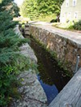
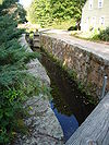
In the sections where it has been completed, it provides thousands of people per day with bicycling, hiking, inline skating and jogging opportunities. Pieces of the original canal still exist, such as an historic "lock house" dating from the time of the original canal, as well as retaining walls, canal locks (elevators for boats), old sections of canal, and other features. In Cheshire
Cheshire, Connecticut
Cheshire is a town in New Haven County, Connecticut, United States. The population was 28,543 at the 2000 census. The center of population of Connecticut is located in Cheshire. In 2009 Cheshire was ranked 72 in Money Magazine's 100 Best Places to Live.Likewise, in 2011 Cheshire was ranked 73 in...
, Connecticut
Connecticut
Connecticut is a state in the New England region of the northeastern United States. It is bordered by Rhode Island to the east, Massachusetts to the north, and the state of New York to the west and the south .Connecticut is named for the Connecticut River, the major U.S. river that approximately...
, the only restored lock along the original Canal line has been incorporated into the Lock 12 Historical Park, which also comprises a small museum.
Trail status
Southern section
As of October 2009, two sections of the trail are paved and open to traffic. With the completion of a 0.5-mile (0.8 km) section in New Haven, there is a continuous 14-mile (23 km) section from Prospect Place in New Haven (41.3137°N 72.9251°W) through the length of HamdenHamden, Connecticut
Hamden is a town in New Haven County, Connecticut, United States. The town's nickname is "The Land of the Sleeping Giant." Hamden is home to Quinnipiac University. The population was 58,180 according to the Census Bureau's 2005 estimates...
to Cornwall Avenue in Cheshire (41.4985°N 72.9144°W). In August 2006, Yale University
Yale University
Yale University is a private, Ivy League university located in New Haven, Connecticut, United States. Founded in 1701 in the Colony of Connecticut, the university is the third-oldest institution of higher education in the United States...
announced it would contribute towards the completion of the final two blocks of the trail through downtown New Haven, from Hillhouse Avenue
Hillhouse Avenue
Hillhouse Avenue, described, according to tradition, by both Charles Dickens and Mark Twain as "the most beautiful street in America," , is in New Haven, Connecticut and is home to many nineteenth century mansions including the president's house at Yale University...
to the Audubon Arts District.
The southern 2-mile section in the town of Southington
Southington, Connecticut
Southington is a town in Hartford County, Connecticut, United States. It is part of Connecticut's 1st congressional district. It is situated about 20 miles southwest of Hartford, about 80 miles northeast of New York City, 105 miles southwest of Boston and 77 miles west of Providence...
was completed in 2010. The last major gap in the trail contains the northern section of Southington, the whole town of Plainville
Plainville, Connecticut
Plainville is a town in Hartford County, Connecticut, United States. The population was 17,328 at the 2000 census.-Geography:According to the United States Census Bureau, the town has a total area of 9.8 square miles , of which 9.8 square miles is land and 0.1 square miles is water...
, which has an approved a feasibility study calling for a proposed route of approximately 4.4 miles in length including both off-road and on-road facilities. To the north of Plainville the last 2.2 miles of Farmington need to be completed. This 9-mile gap is the largest remaining in Connecticut.
In December 2010 the Town of Cheshire indicated it will begin plans and design on the construction of a new section from West Main Street (Connecticut Route 70) to Jarvis Street and has assembled more than $812,000 in federal and state funding. It is anticipated that Cheshire will add one million dollars to the grants to complete this new section.
On December 14, 2010 a Connecticut Department of Environmental Protection (CT DEP) grant for $250,000 was accepted and added to existing federal grants of $562,000. There are a number of reasons for the Town of Cheshire to favor building the new unconnected section rather than extending the current trail north from Cornwall Avenue : the difficult issues involving in acquiring rights of way as well as building a path through the wetlands from Cornwall Avenue to West Main Street, the current traffic safety issue for bicycle and pedestrian traffic crossing West Main Street and the offer by the state of Connecticut to help pay for the design of the connecting section from Jarvis Street to the Town of Southington's section of trail.
The biggest project of 2011 has been the construction of a tunnel under Skiff Street in Hamden so that users of the trail do not have to detour up to Skiff Street to cross it. Construction is nearing completion and a dedication will be held on Friday, October 21st, 2011. Funding for the tunnel became available when the bids for the final phase of Hamden's portion of the trail came in about $1 million less than forecast, a sign of the economic times. Because of the shortage in funds for the completion of Hamden's portion of the trail, the funds that were raised were able to be reallocated to the tunnel under Skiff Street.
There is a project in progress under the supervision of the trail's Board of Directors to widen and realign the portion of the trail in Hamden where West Woods Road meets Mt. Carmel Avenue, a spot where the trail gets close to Whitney Ave. That project has been underway for about a year and is also nearing completion, although probably not until early in 2012.
If you are looking for a place to park near the trail, a great spot can be found on Sherman Avenue by the York Hill Campus Entrance to Quinnipiac University.
Middle Section
The middle section includes about 27 miles (43.5 km) of paved multi-use trail. All of this section is paved and well marked, including East Coast Greenway blazes for the applicable segment up to Route 315 in Simsbury. Almost all of it is off road, although there are numerous road crossings, and some sections run alongside roads similar to a sidewalk. As of July 2009, the bridge which carries the trail over Salmon Brook in Granby is completed. As of October 2009 the .37-mile gap in Suffield has been paved to the Massachusetts line, so that the trail is now continuous from Farmington (41.7280°N 72.8620°W) through Southwick, MA - a distance of 27 miles. Both Simsbury and Avon completed short pieces of on-road trail in their town centers recently. Intersections with the Farmington River Trail are (1) near the start of the trail, on Red Oak Hill Rd/New Britain Ave. in Farmington, and (2) at the intersection of Rt. 10 and Drake Hill Rd. in Simsbury. Coordinates for all parking lots and facilities can be found at http://www.fvgreenway.org/pdfs/FVTC_Parking_Lots_v5.pdf.Northern Section
Southwick, MA has finished 6.4 miles to the Westfield, MA line (42.1058°N 72.7438°W). Westfield's section of about 3.2 miles has been approved by MassHighway, to include 9 bridges making it (once completed) one of the very few elevated trails in America. Southampton is working on the purchase of the railroad right of way. Easthampton's Manhan Trail is now 3.7 miles long and will become part of the larger Canal Heritqge Trail. Northampton, MA is finally complete as of 2011.See also
- Farmington CanalFarmington CanalThe Farmington Canal, also known as the New Haven and Northampton Canal, was a major private canal built in the early 19th century to provide water transportation from New Haven into the interior of Connecticut, Massachusetts and beyond. Its Massachusetts segment was known as the Hampshire and...
- Hampshire and Hampden CanalHampshire and Hampden CanalThe Hampshire and Hampden Canal was the Massachusetts segment of an canal that once connected New Haven, Connecticut to the Connecticut River north of Northampton, Massachusetts...
- New Haven and Northampton Company
External links
- Farmington Canal Rail to Trail Association/Farmington Canal Trail (Southern section - New Haven to Plainville)
- Farmington Valley Trails Council/Farmington Valley Greenway (Northern Section - Farmington to Suffield)
- The East Coast Greenway on Google Maps: Connecticut (Includes the entire Southern section, and about 2/3 of the Northern Section)