

Falling Water River
Encyclopedia
Middle Tennessee
Middle Tennessee is a distinct portion of the state of Tennessee, delineated according to state law as the 41 counties in the Middle Grand Division of Tennessee....
Tennessee
Tennessee
Tennessee is a U.S. state located in the Southeastern United States. It has a population of 6,346,105, making it the nation's 17th-largest state by population, and covers , making it the 36th-largest by total land area...
in the United States
United States
The United States of America is a federal constitutional republic comprising fifty states and a federal district...
. It is a tributary of the Caney Fork of the Cumberland River
Cumberland River
The Cumberland River is a waterway in the Southern United States. It is long. It starts in Harlan County in far southeastern Kentucky between Pine and Cumberland mountains, flows through southern Kentucky, crosses into northern Tennessee, and then curves back up into western Kentucky before...
. By the Cumberland and Ohio
Ohio River
The Ohio River is the largest tributary, by volume, of the Mississippi River. At the confluence, the Ohio is even bigger than the Mississippi and, thus, is hydrologically the main stream of the whole river system, including the Allegheny River further upstream...
rivers, it is part of the Mississippi River
Mississippi River
The Mississippi River is the largest river system in North America. Flowing entirely in the United States, this river rises in western Minnesota and meanders slowly southwards for to the Mississippi River Delta at the Gulf of Mexico. With its many tributaries, the Mississippi's watershed drains...
watershed.
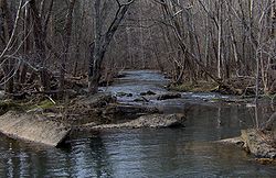
It rises in Putnam County
Putnam County, Tennessee
Putnam County is a county located in the U.S. state of Tennessee. As of 2000, the population was 62,315, a 21 percent increase from 1990. The was 72,321, an increase of 16.1% since 2000...
in a dissected portion of the Cumberland Plateau
Cumberland Plateau
The Cumberland Plateau is the southern part of the Appalachian Plateau. It includes much of eastern Kentucky and western West Virginia, part of Tennessee, and a small portion of northern Alabama and northwest Georgia . The terms "Allegheny Plateau" and the "Cumberland Plateau" both refer to the...
. The stream descends rather steeply and is crossed by Interstate 40
Interstate 40
Interstate 40 is the third-longest major east–west Interstate Highway in the United States, after I-90 and I-80. Its western end is at Interstate 15 in Barstow, California; its eastern end is at a concurrency of U.S. Route 117 and North Carolina Highway 132 in Wilmington, North Carolina...
. Just south of the Interstate, the stream is impounded by a small dam forming the City Lake for the Putnam County seat of Cookeville
Cookeville, Tennessee
Cookeville is a city in Putnam County, Tennessee, United States. The population was 23,923 at the 2000 census. of Cookeville's population was 30,435, and the combined total of those living in Cookeville's in 2010 was 65,014. It is the county seat of Putnam County and home to Tennessee...
. Flowing generally southwest, the stream crosses into White County
White County, Tennessee
White County is a county located in the U.S. state of Tennessee. As of 2000, the population was 23,102. Its county seat is Sparta.-History:...
briefly and then becomes the White County - Putnam County line.
After a short distance, the stream is impounded by a dam that formerly was the electrical power source for the town of Cookeville prior to the advent of the Tennessee Valley Authority
Tennessee Valley Authority
The Tennessee Valley Authority is a federally owned corporation in the United States created by congressional charter in May 1933 to provide navigation, flood control, electricity generation, fertilizer manufacturing, and economic development in the Tennessee Valley, a region particularly affected...
. This dam's original purpose was to divert the flow of the water through a powerhouse that was located at the base of the last of a series of three waterfalls, the last and highest of which is Burgess Falls
Burgess Falls State Park
Burgess Falls State Park is a state park and state natural area in Putnam County and White County, Tennessee, located in the southeastern United States...
, the focus of a state natural area. Burgess Falls is 136 feet (41.5 m) high and is generally considered to be among the most scenic waterfalls in Middle Tennessee. The reservoir behind the dam is now managed by the Tennessee Wildlife Resources Agency
Tennessee Wildlife Resources Agency
The Tennessee Wildlife Resources Agency is an independent state agency of the state of Tennessee with the mission of managing the state's fish and wildlife and their habitats, as well as responsibility for all wildlife-related law enforcement activities...
. The area has been minimally developed since its acquisition by the state with walkways, hiking trails, and a paved parking area.
Below Burgess Falls the water of the Falling Water River becomes slack as part of the Center Hill Lake
Center Hill Lake
Center Hill Lake is a reservoir in the U.S. state of Tennessee. It is located in Middle Tennessee near Smithville. Created by means of a dam constructed by the U.S. Army Corps of Engineers in 1948, the lake had a dual purpose: electricity production and flood control...
impoundment of the Caney Fork, an Army Corps of Engineers project. The falls mark the descent of the riverbed from the Highland Rim
Highland Rim
The Highland Rim is a geographic term for the area in Tennessee surrounding the Central Basin. Nashville is largely surrounded by higher terrain in all directions....
into the Nashville Basin
Nashville Basin
The Nashville Basin, also known as the Central Basin, is a term often used to describe the area surrounding Nashville, Tennessee. The Central Basin was caused by an uplifting known as the Nashville Dome. The Nashville Dome is evidenced by the underlying rock strata that all dip downwards away from...
over a particularly resistant layer of sedimentary rock
Sedimentary rock
Sedimentary rock are types of rock that are formed by the deposition of material at the Earth's surface and within bodies of water. Sedimentation is the collective name for processes that cause mineral and/or organic particles to settle and accumulate or minerals to precipitate from a solution....
from the Paleozoic Era.