

Extreme points of Wales
Encyclopedia
Wales
- Northernmost point – Middle MouseMiddle MouseMiddle Mouse is an uninhabited island situated 1 kilometre off the north coast of Anglesey. It is notable as the northernmost point of Wales. The island measures a maximum of 207 metres by 110 metres, with a maximum area of 3.7 acres and has a maximum altitude of 16 metres above sea level...
, off AngleseyAngleseyAnglesey , also known by its Welsh name Ynys Môn , is an island and, as Isle of Anglesey, a county off the north west coast of Wales...
at 53°26′N 4°26′W - Northernmost settlement – Llanlleiana, AngleseyAngleseyAnglesey , also known by its Welsh name Ynys Môn , is an island and, as Isle of Anglesey, a county off the north west coast of Wales...
at 53°25′N 4°25′W
- Southernmost point – Flat HolmFlat HolmFlat Holm is a limestone island lying in the Bristol Channel approximately from Lavernock Point in the Vale of Glamorgan, but in the City and County of Cardiff. It includes the most southerly point of Wales....
, CardiffCardiffCardiff is the capital, largest city and most populous county of Wales and the 10th largest city in the United Kingdom. The city is Wales' chief commercial centre, the base for most national cultural and sporting institutions, the Welsh national media, and the seat of the National Assembly for...
, off Lavernock Point, Vale of GlamorganVale of GlamorganThe Vale of Glamorgan is a county borough in Wales; an exceptionally rich agricultural area, it lies in the southern part of Glamorgan, South Wales...
at 51°22′N 3°7′W - Southernmost settlement – RhooseRhooseRhoose is a village and community located near the sea in the Vale of Glamorgan, Wales, near Barry.The village is the location of Cardiff International Airport, formerly RAF Rhoose, a Holiday Park , some shops, two public houses , Rhoose Social Club, and an active Surf Life Saving Club Rhoose is...
, Vale of GlamorganVale of GlamorganThe Vale of Glamorgan is a county borough in Wales; an exceptionally rich agricultural area, it lies in the southern part of Glamorgan, South Wales...
at 51°23′N 3°20′W
- Westernmost point – The SmallsThe SmallsThe Smalls were a hard rock/metal band from Edmonton, Alberta, with jazz, hardcore punk, speed metal and country music influences. They were probably the most prominent Alberta band in the second wave of performers coming out of the Canadian west coast DIY scene that was first ushered into Alberta...
, PembrokeshirePembrokeshirePembrokeshire is a county in the south west of Wales. It borders Carmarthenshire to the east and Ceredigion to the north east. The county town is Haverfordwest where Pembrokeshire County Council is headquartered.... - Westernmost settlement – Treginnis, PembrokeshirePembrokeshirePembrokeshire is a county in the south west of Wales. It borders Carmarthenshire to the east and Ceredigion to the north east. The county town is Haverfordwest where Pembrokeshire County Council is headquartered....
at 51°52′N 5°18′W
- Easternmost point – Lady Park Wood, near MonmouthMonmouthMonmouth is a town in southeast Wales and traditional county town of the historic county of Monmouthshire. It is situated close to the border with England, where the River Monnow meets the River Wye with bridges over both....
, MonmouthshireMonmouthshireMonmouthshire is a county in south east Wales. The name derives from the historic county of Monmouthshire which covered a much larger area. The largest town is Abergavenny. There are many castles in Monmouthshire .-Historic county:...
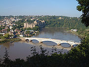
at 51°49′N 2°39′W - Easternmost settlement – ChepstowChepstowChepstow is a town in Monmouthshire, Wales, adjoining the border with Gloucestershire, England. It is located on the River Wye, close to its confluence with the River Severn, and close to the western end of the Severn Bridge on the M48 motorway...
, MonmouthshireMonmouthshireMonmouthshire is a county in south east Wales. The name derives from the historic county of Monmouthshire which covered a much larger area. The largest town is Abergavenny. There are many castles in Monmouthshire .-Historic county:...
at 51°37′N 2°39′W
Wales (mainland)
- Northernmost point – Point of AyrPoint of AyrPoint of Ayr is the northernmost point of mainland Wales. It is situated immediately to the north of Talacre in Flintshire, at the mouth of the Dee estuary. It is to the southwest of the Liverpool Bay area of the Irish Sea...
, FlintshireFlintshireFlintshire is a county in north-east Wales. It borders Denbighshire, Wrexham and the English county of Cheshire. It is named after the historic county of Flintshire, which had notably different borders...
at 53°21′N 3°19′W - Northernmost settlement – TalacreTalacreTalacre is a village in Flintshire on the North Wales coast with large holiday caravan parks adjacent. It is near Point of Ayr on the west side of the River Dee estuary and has a sandy beach with dunes. The hills of the Clwydian Range behind the village form the eastern boundary of the Vale of Clwyd...
, FlintshireFlintshireFlintshire is a county in north-east Wales. It borders Denbighshire, Wrexham and the English county of Cheshire. It is named after the historic county of Flintshire, which had notably different borders...
at 53°21′N 3°19′W
- Southernmost point – Breaksea PointBreaksea PointBreaksea Point is the southernmost point of mainland Wales .- Location :Breaksea Point is located in the Vale of Glamorgan and is part of the Heritage Coast of South Wales....
, Vale of GlamorganVale of GlamorganThe Vale of Glamorgan is a county borough in Wales; an exceptionally rich agricultural area, it lies in the southern part of Glamorgan, South Wales...
at 51°22′N 3°24′W - Southernmost settlement – RhooseRhooseRhoose is a village and community located near the sea in the Vale of Glamorgan, Wales, near Barry.The village is the location of Cardiff International Airport, formerly RAF Rhoose, a Holiday Park , some shops, two public houses , Rhoose Social Club, and an active Surf Life Saving Club Rhoose is...
, Vale of GlamorganVale of GlamorganThe Vale of Glamorgan is a county borough in Wales; an exceptionally rich agricultural area, it lies in the southern part of Glamorgan, South Wales...
at 51°23′N 3°20′W
- Westernmost point – Pen Dal-aderynPen Dal-aderynPen Dal-aderyn is the westernmost point of mainland Wales.It is located in Pembrokeshire, west of St David's.-External links:...
, PembrokeshirePembrokeshirePembrokeshire is a county in the south west of Wales. It borders Carmarthenshire to the east and Ceredigion to the north east. The county town is Haverfordwest where Pembrokeshire County Council is headquartered....
at 51°51′N 5°19′W - Westernmost settlement – Treginnis, PembrokeshirePembrokeshirePembrokeshire is a county in the south west of Wales. It borders Carmarthenshire to the east and Ceredigion to the north east. The county town is Haverfordwest where Pembrokeshire County Council is headquartered....
at 51°52′N 5°18′W
- Easternmost point – Lady Park Wood, near MonmouthMonmouthMonmouth is a town in southeast Wales and traditional county town of the historic county of Monmouthshire. It is situated close to the border with England, where the River Monnow meets the River Wye with bridges over both....
, MonmouthshireMonmouthshireMonmouthshire is a county in south east Wales. The name derives from the historic county of Monmouthshire which covered a much larger area. The largest town is Abergavenny. There are many castles in Monmouthshire .-Historic county:...
at 51°49′N 2°39′W - Easternmost settlement – ChepstowChepstowChepstow is a town in Monmouthshire, Wales, adjoining the border with Gloucestershire, England. It is located on the River Wye, close to its confluence with the River Severn, and close to the western end of the Severn Bridge on the M48 motorway...
, MonmouthshireMonmouthshireMonmouthshire is a county in south east Wales. The name derives from the historic county of Monmouthshire which covered a much larger area. The largest town is Abergavenny. There are many castles in Monmouthshire .-Historic county:...
at 51°37′N 2°39′W
Centre point
The centre point of Wales is dependent on whether only the mainland is used for calculation or outlying islands as well.One centre point is calculated to be near Cwmystwyth
Cwmystwyth
Cwmystwyth is a village located in Ceredigion, Wales near Devil's Bridge, and Pont-rhyd-y-groes.The Ordnance Survey calculates Cwmystwyth to be the Centre point of Wales, - History :See Cwmystwyth Mines...
, Devil's Bridge
Devil's Bridge, Ceredigion
Devil's Bridge is a village in Ceredigion, Wales.- Description :The bridge spans the Mynach, a tributary of the Rheidol. The bridge is unusual in that three separate bridges are coexistent, each one built upon the previous bridge...
, Ceredigion
Ceredigion
Ceredigion is a county and former kingdom in mid-west Wales. As Cardiganshire , it was created in 1282, and was reconstituted as a county under that name in 1996, reverting to Ceredigion a day later...
(52°19′48.791"N 3°45′59.072"W; )
Elevation extremes
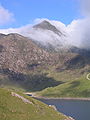
- Wales: SnowdonSnowdonSnowdon is the highest mountain in Wales, at an altitude of above sea level, and the highest point in the British Isles outside Scotland. It is located in Snowdonia National Park in Gwynedd, and has been described as "probably the busiest mountain in Britain"...
(Yr Wyddfa) in SnowdoniaSnowdoniaSnowdonia is a region in north Wales and a national park of in area. It was the first to be designated of the three National Parks in Wales, in 1951.-Name and extent:...
(Eryri) - 1,085 m (3,560 ft)
Many points are on, or near sea level, but due to high rainfall, there are no natural dry pieces of land below sea level - see rivers and lakes below.
Rivers and lakes
The largest natural lakeLake
A lake is a body of relatively still fresh or salt water of considerable size, localized in a basin, that is surrounded by land. Lakes are inland and not part of the ocean and therefore are distinct from lagoons, and are larger and deeper than ponds. Lakes can be contrasted with rivers or streams,...
in Wales is Llyn Tegid (Bala Lake). Llangorse Lake
Llangorse Lake
Llangorse Lake is the largest natural lake in south Wales, and is situated in the Brecon Beacons National Park, near to the town of Brecon and the village of Llangors....
is second largest.
This is a table of the longest rivers in Wales.
Rivers only partly in Wales are included in this table in italics.
| River | Length (miles) | (km) | |
|---|---|---|---|
| 1 | River Severn River Severn The River Severn is the longest river in Great Britain, at about , but the second longest on the British Isles, behind the River Shannon. It rises at an altitude of on Plynlimon, Ceredigion near Llanidloes, Powys, in the Cambrian Mountains of mid Wales... | 220 | 354 |
| 2 | River Wye River Wye The River Wye is the fifth-longest river in the UK and for parts of its length forms part of the border between England and Wales. It is important for nature conservation and recreation.-Description:... | 135 | 215 |
| 3 | River Dee River Dee, Wales The River Dee is a long river in the United Kingdom. It travels through Wales and England and also forms part of the border between the two countries.... | 70 | 112 |
| 4 | River Towy | 68 | 109 |
| 5 | River Usk River Usk The River Usk rises on the northern slopes of the Black Mountain of mid-Wales, in the easternmost part of the Brecon Beacons National Park. Initially it flows north into Usk Reservoir, then east by Sennybridge to Brecon before turning southeast to flow by Talybont-on-Usk, Crickhowell and... | 56 | 90 |
| 6 | River Teifi River Teifi The River Teifi forms the boundary between the counties of Ceredigion and Carmarthenshire in south-west Wales for most of its 75 mile length, flowing into the sea below the town of Cardigan. The catchment of the river is estimated to be 1,008 square kilometres yielding an average flow at Glan... | 50 | 80 |
| 7 | River Taff River Taff The River Taff is a large river in Wales. It rises as two rivers in the Brecon Beacons — the Taf Fechan and the Taf Fawr — before joining to form the Taff north of Merthyr Tydfil... | 40 | 64 |
See also
- Centre points of the United KingdomCentre points of the United KingdomThere has long been debate over the exact location of the geographical centre of the United Kingdom, and its constituent countries, due to the complexity and method of the calculation, such as whether to include offshore islands, and the fact that erosion will cause the position to change over time...
- Geography of WalesGeography of WalesWales is a generally mountainous country on the western side of central southern Great Britain, between the Irish Sea to the north and the Bristol Channel to the south. It is part of the United Kingdom, and is bordered by England to its east and the Atlantic Ocean, St George's Channel and Irish...
- List of mountains and hills of Wales
- Extreme points of the British IslesExtreme points of the British IslesThis is a list of the extreme points of the British Isles1, the points that are farther north, south, east or west than any other location*Northernmost Point — Out Stack, Shetland Islands*Northernmost Settlement — Skaw, Unst, Shetland Islands...