
Extreme points of Scotland
Encyclopedia
This is a list of the extreme points and extreme elevations in Scotland
.
The northernmost and westernmost points of Scotland coincide with those of the UK
(both for the mainland and including the islands).
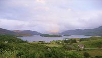
Schiehallion
, a mountain in Perthshire
, is sometimes described as the centre of Scotland
.
However, 2002 studies by the Ordnance Survey
pinpointed the centres more precisely, and it is their results that are quoted here. However, this is obviously dependent on whether or not Scotland's islands are included, and there is more than one way to measure it.
The ten tallest mountain
s in the UK are all found in Scotland.
Wanlockhead
claims to be the highest settlement in Scotland.
Many points are on, or near sea level, but due to high rainfall, there are no natural dry pieces of land below sea level - see rivers and lochs below.
 Main articles:
The longest river in Scotland is the River Tay
(117 mi, 188 km).
The largest (freshwater) loch in Scotland is:
The deepest freshwater loch is Loch Morar
with a maximum depth of 309 metres (Loch Ness
is second at 228 metres deep).
Scotland
Scotland is a country that is part of the United Kingdom. Occupying the northern third of the island of Great Britain, it shares a border with England to the south and is bounded by the North Sea to the east, the Atlantic Ocean to the north and west, and the North Channel and Irish Sea to the...
.
The northernmost and westernmost points of Scotland coincide with those of the UK
Extreme points of the United Kingdom
This is a list of the extreme points of the United Kingdom: the points that are farther north, south, east or west than any other location. Traditionally the extent of the island of Great Britain has stretched "from Land's End to John o' Groats" .This article does not include references to the...
(both for the mainland and including the islands).
General
- Northernmost point – Out StackOut StackOut Stack or Ootsta in Shetland, Scotland, is the northernmost of the British Isles, lying immediately to the north of Muckle Flugga and north of the island of Unst. It is one of the North Isles of the Shetland Islands and lies within the Hermaness National Nature Reserve.Out Stack is little more...
, Shetland IslandsShetland IslandsShetland is a subarctic archipelago of Scotland that lies north and east of mainland Great Britain. The islands lie some to the northeast of Orkney and southeast of the Faroe Islands and form part of the division between the Atlantic Ocean to the west and the North Sea to the east. The total...
at 60°51′N 0°52′W - Northernmost settlement – SkawSkawSkaw is a tiny settlement on the Shetland island of Unst. It is located north of Haroldswick on a peninsula in the northeast corner of the island, and is the most northerly settlement in the United Kingdom...
, UnstUnstUnst is one of the North Isles of the Shetland Islands, Scotland. It is the northernmost of the inhabited British Isles and is the third largest island in Shetland after the Mainland and Yell. It has an area of .Unst is largely grassland, with coastal cliffs...
, Shetland IslandsShetland IslandsShetland is a subarctic archipelago of Scotland that lies north and east of mainland Great Britain. The islands lie some to the northeast of Orkney and southeast of the Faroe Islands and form part of the division between the Atlantic Ocean to the west and the North Sea to the east. The total...
at 60°49′N 0°47′W
- Southernmost point – Mull of GallowayMull of GallowayThe Mull of Galloway is the southernmost point of Scotland. It is situated in Wigtownshire, Dumfries and Galloway.A lighthouse is positioned at the point . Built in 1830 by engineer Robert Stevenson, the white-painted round tower is high...
, WigtownshireWigtownshireWigtownshire or the County of Wigtown is a registration county in the Southern Uplands of south west Scotland. Until 1975, the county was one of the administrative counties used for local government purposes, and is now administered as part of the council area of Dumfries and Galloway...
at 54°38′N 4°52′W - Southernmost settlement – CairngaanCairngaanCairngaan, Dumfries and Galloway, is the southmost settlement in Scotland. The hamlet of Cairngaan lies just north of the Mull of Galloway on the B7041, after a turn-off from the B7065 road...
, WigtownshireWigtownshireWigtownshire or the County of Wigtown is a registration county in the Southern Uplands of south west Scotland. Until 1975, the county was one of the administrative counties used for local government purposes, and is now administered as part of the council area of Dumfries and Galloway...
at 54°38′N 4°54′W
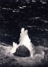
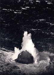
- Westernmost point – RockallRockallRockall is an extremely small, uninhabited, remote rocky islet in the North Atlantic Ocean. It gives its name to one of the sea areas named in the shipping forecast provided by the British Meteorological Office....
1 at 57°35′N 13°41′W - Westernmost settlement – CaolasCaolasCaolas in Bhatarsaigh is the westernmost settlement in Scotland and the United Kingdom. Previously, the village on Hirta claimed this "crown".Caolas is a word meaning "straits" and frequently rendered as "kyles" in English....
, Bhatarsaigh (Vatersay), Outer HebridesOuter HebridesThe Outer Hebrides also known as the Western Isles and the Long Island, is an island chain off the west coast of Scotland. The islands are geographically contiguous with Comhairle nan Eilean Siar, one of the 32 unitary council areas of Scotland...
at 56°56′N 7°32′W
- Easternmost point – Bound SkerryBound SkerryBound Skerry is part of the Out Skerries group in the Shetland Islands. As well as being the most easterly island of that group, it is also the easternmost point of Scotland....
, Out Skerries, Shetland IslandsShetland IslandsShetland is a subarctic archipelago of Scotland that lies north and east of mainland Great Britain. The islands lie some to the northeast of Orkney and southeast of the Faroe Islands and form part of the division between the Atlantic Ocean to the west and the North Sea to the east. The total...
at 60°25′N 0°43′W - Easternmost settlement – BrurayBrurayBruray is one of the three Out Skerries islands of Shetland, and contains Scotland's most easterly settlement.It is separated from Housay by North Mouth and South Mouth.-Infrastructure:...
, Out Skerries, Shetland IslandsShetland IslandsShetland is a subarctic archipelago of Scotland that lies north and east of mainland Great Britain. The islands lie some to the northeast of Orkney and southeast of the Faroe Islands and form part of the division between the Atlantic Ocean to the west and the North Sea to the east. The total...
at 60°26′N 0°45′W
Mainland
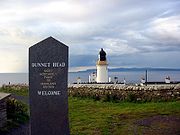
- Northernmost point – Dunnet HeadDunnet HeadDunnet Head is a peninsula in Caithness, on the north coast of Scotland, that includes the most northerly point of the mainland of Great Britain. The point, known as Easter Head, is at , about westnorthwest of John o' Groats and about from Duncansby Head...
at 58°40′N 3°22′W, known also as Easter Head, CaithnessCaithnessCaithness is a registration county, lieutenancy area and historic local government area of Scotland. The name was used also for the earldom of Caithness and the Caithness constituency of the Parliament of the United Kingdom . Boundaries are not identical in all contexts, but the Caithness area is...
, HighlandHighland (council area)Highland is a council area in the Scottish Highlands and is the largest local government area in both Scotland and the United Kingdom as a whole. It shares borders with the council areas of Moray, Aberdeenshire, Perth and Kinross, and Argyll and Bute. Their councils, and those of Angus and...
, ScotlandScotlandScotland is a country that is part of the United Kingdom. Occupying the northern third of the island of Great Britain, it shares a border with England to the south and is bounded by the North Sea to the east, the Atlantic Ocean to the north and west, and the North Channel and Irish Sea to the... - Northernmost settlement – Scarfskerry, CaithnessCaithnessCaithness is a registration county, lieutenancy area and historic local government area of Scotland. The name was used also for the earldom of Caithness and the Caithness constituency of the Parliament of the United Kingdom . Boundaries are not identical in all contexts, but the Caithness area is...
, HighlandHighland (council area)Highland is a council area in the Scottish Highlands and is the largest local government area in both Scotland and the United Kingdom as a whole. It shares borders with the council areas of Moray, Aberdeenshire, Perth and Kinross, and Argyll and Bute. Their councils, and those of Angus and...
, ScotlandScotlandScotland is a country that is part of the United Kingdom. Occupying the northern third of the island of Great Britain, it shares a border with England to the south and is bounded by the North Sea to the east, the Atlantic Ocean to the north and west, and the North Channel and Irish Sea to the...
at 58°39′N 3°15′W
- Southernmost point – Mull of GallowayMull of GallowayThe Mull of Galloway is the southernmost point of Scotland. It is situated in Wigtownshire, Dumfries and Galloway.A lighthouse is positioned at the point . Built in 1830 by engineer Robert Stevenson, the white-painted round tower is high...
, WigtownshireWigtownshireWigtownshire or the County of Wigtown is a registration county in the Southern Uplands of south west Scotland. Until 1975, the county was one of the administrative counties used for local government purposes, and is now administered as part of the council area of Dumfries and Galloway...
at 54°38′N 4°52′W - Southernmost settlement – CairngaanCairngaanCairngaan, Dumfries and Galloway, is the southmost settlement in Scotland. The hamlet of Cairngaan lies just north of the Mull of Galloway on the B7041, after a turn-off from the B7065 road...
, WigtownshireWigtownshireWigtownshire or the County of Wigtown is a registration county in the Southern Uplands of south west Scotland. Until 1975, the county was one of the administrative counties used for local government purposes, and is now administered as part of the council area of Dumfries and Galloway...
at 54°38′N 4°54′W
- Westernmost point – Corrachadh MòrCorrachadh MorCorrachadh Mòr ETRS89 is a small hillock on the Ardnamurchan peninsula in Lochaber, Highland, Scotland, notable for adjoining the most westerly point on the island of Great Britain. It is about further west than Land's End in Cornwall....
, HighlandHighland (council area)Highland is a council area in the Scottish Highlands and is the largest local government area in both Scotland and the United Kingdom as a whole. It shares borders with the council areas of Moray, Aberdeenshire, Perth and Kinross, and Argyll and Bute. Their councils, and those of Angus and...
at 56°42′N 6°13′W - Westernmost settlement – GrigadaleGrigadaleGrigadale , in Ardnamurchan in the Highland Council Area, is the most westerly settlement on the mainland of Scotland....
, HighlandHighland (council area)Highland is a council area in the Scottish Highlands and is the largest local government area in both Scotland and the United Kingdom as a whole. It shares borders with the council areas of Moray, Aberdeenshire, Perth and Kinross, and Argyll and Bute. Their councils, and those of Angus and...
at 56°43′N 6°11′W
- Easternmost point – Keith InchKeith InchNot to be confused with "Inchkeith", in the Firth of ForthKeith Inch is the easternmost point of mainland Scotland.It is located in Peterhead in Aberdeenshire, forming the north point of Peterhead Bay at ....
, AberdeenshireAberdeenshireAberdeenshire is one of the 32 unitary council areas in Scotland and a lieutenancy area.The present day Aberdeenshire council area does not include the City of Aberdeen, now a separate council area, from which its name derives. Together, the modern council area and the city formed historic...
at 57°30′N 1°46′W - Easternmost settlement – PeterheadPeterheadPeterhead is a town in Aberdeenshire, Scotland. It is Aberdeenshire's biggest settlement , with a population of 17,947 at the 2001 Census and estimated to have fallen to 17,330 by 2006....
, AberdeenshireAberdeenshireAberdeenshire is one of the 32 unitary council areas in Scotland and a lieutenancy area.The present day Aberdeenshire council area does not include the City of Aberdeen, now a separate council area, from which its name derives. Together, the modern council area and the city formed historic...
at 57°30′N 1°46′W
Centre point
- Between Blair AthollBlair AthollBlair Atholl is a small town in Perthshire, Scotland, built about the confluence of the Rivers Tilt and Garry in one of the few areas of flat land in the midst of the Grampian Mountains. The Gaelic place-name Blair, from blàr, 'field, plain', refers to this location...
and DalwhinnieDalwhinnieDalwhinnie "Meeting Place" is a small village in the Scottish Highlands.-Location:Dalwhinnie sits at an altitude of 351 m. It is one of the coldest villages in the UK, having an average annual temperature of 6.5oC, making it suitable for winter walking and mountaineering.It is north of Drumochter,...
, PerthshirePerthshirePerthshire, officially the County of Perth , is a registration county in central Scotland. It extends from Strathmore in the east, to the Pass of Drumochter in the north, Rannoch Moor and Ben Lui in the west, and Aberfoyle in the south...
(56°49′0.257"N 4°11′2.267"W; )
Schiehallion
Schiehallion
Schiehallion is a prominent mountain in Perth and Kinross, Scotland. Schiehallion has a rich botanical life, interesting archaeology, and a unique place in scientific history for an 18th-century experiment in 'weighing the world'...
, a mountain in Perthshire
Perthshire
Perthshire, officially the County of Perth , is a registration county in central Scotland. It extends from Strathmore in the east, to the Pass of Drumochter in the north, Rannoch Moor and Ben Lui in the west, and Aberfoyle in the south...
, is sometimes described as the centre of Scotland
Scotland
Scotland is a country that is part of the United Kingdom. Occupying the northern third of the island of Great Britain, it shares a border with England to the south and is bounded by the North Sea to the east, the Atlantic Ocean to the north and west, and the North Channel and Irish Sea to the...
.
However, 2002 studies by the Ordnance Survey
Ordnance Survey
Ordnance Survey , an executive agency and non-ministerial government department of the Government of the United Kingdom, is the national mapping agency for Great Britain, producing maps of Great Britain , and one of the world's largest producers of maps.The name reflects its creation together with...
pinpointed the centres more precisely, and it is their results that are quoted here. However, this is obviously dependent on whether or not Scotland's islands are included, and there is more than one way to measure it.
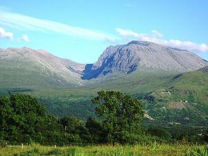
Elevation extremes
- Scotland: Ben NevisBen NevisBen Nevis is the highest mountain in the British Isles. It is located at the western end of the Grampian Mountains in the Lochaber area of the Scottish Highlands, close to the town of Fort William....
(Aonach MòrAonach MòrAonach Mòr is a mountain in the Highlands of Scotland. It is located about 2 miles/ 3 km north east of Ben Nevis on the south side of Glen Spean, near the town of Fort William...
, 1,344 metres)
The ten tallest mountain
Mountain
Image:Himalaya_annotated.jpg|thumb|right|The Himalayan mountain range with Mount Everestrect 58 14 160 49 Chomo Lonzorect 200 28 335 52 Makalurect 378 24 566 45 Mount Everestrect 188 581 920 656 Tibetan Plateaurect 250 406 340 427 Rong River...
s in the UK are all found in Scotland.
Wanlockhead
Wanlockhead
Wanlockhead is a village in Dumfries and Galloway, Scotland nestling in the Lowther Hills one mile south of Leadhills at the head of the Mennock Pass, which forms part of the Southern Uplands...
claims to be the highest settlement in Scotland.
Many points are on, or near sea level, but due to high rainfall, there are no natural dry pieces of land below sea level - see rivers and lochs below.
Rivers and lochs
- List of lochs in Scotland;
- Rivers of Scotland;
The longest river in Scotland is the River Tay
River Tay
The River Tay is the longest river in Scotland and the seventh-longest in the United Kingdom. The Tay originates in western Scotland on the slopes of Ben Lui , then flows easterly across the Highlands, through Loch Dochhart, Loch Lubhair and Loch Tay, then continues east through Strathtay , in...
(117 mi, 188 km).
The largest (freshwater) loch in Scotland is:
- Scotland: Loch LomondLoch LomondLoch Lomond is a freshwater Scottish loch, lying on the Highland Boundary Fault. It is the largest lake in Great Britain by surface area. The lake contains many islands, including Inchmurrin, the largest fresh-water island in the British Isles, although the lake itself is smaller than many Irish...
(27.46 sq mi, 71.12 km²)
The deepest freshwater loch is Loch Morar
Loch Morar
Loch Morar is a freshwater loch in Morar, Lochaber, Highland, Scotland. It is the fifth-largest loch in Scotland, with a surface area of and the deepest freshwater body in the British Isles, with a maximum depth of ....
with a maximum depth of 309 metres (Loch Ness
Loch Ness
Loch Ness is a large, deep, freshwater loch in the Scottish Highlands extending for approximately southwest of Inverness. Its surface is above sea level. Loch Ness is best known for the alleged sightings of the cryptozoological Loch Ness Monster, also known affectionately as "Nessie"...
is second at 228 metres deep).