
Exhumed river channel
Encyclopedia
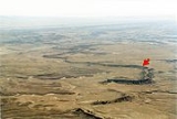
An exhumed river channel is a ridge of sandstone
that remains when the softer flood plain mudstone
is eroded
away. The process begins with the deposition of sand within a river
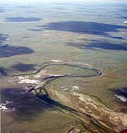
channel (typically a meander
ing river) and mud on the adjacent floodplain
. Eventually the channel is abandoned and over time becomes buried by flood deposits from other channels. Because the sand is porous (grain-to-grain contact leaves spaces between), groundwater
flows more easily through the sand than through the mud of the floodplain deposits.
 Minerals (typically calcium carbonate
) can cement the grains together converting the loose sand into sandstone. Meanwhile, pressure from overlying sediment
s compresses the floodplain mud converting it to mudstone. Millions of years later, erosion can remove the softer, less cemented mudstone and leave the more resistant sandstone as a sinuous ridge. Thus, the local landscape where these occur is an inverted topography: what was previously low is now high, and vice versa. Exhumed channels are important indicators for ancient stream flow direction.
Some of the best examples of exhumed river channels occur in the Ruby Ranch Member of the Cretaceous
Cedar Mountain Formation
southwest of Green River, Utah
. Within the Cedar Mountain Formation in this part of Utah, fluvial sandstone
s filling paleochannels within it are cemented by calcium carbonate
. Because of this cementation, the sandtone filling these paleochannels are considerably more resistant to erosion than the shale
and mudstone
that enclose them. As a result, differential erosion preferentially removes the shale and mudstone and exposes these paleochannels as ridges..
Sandstone
Sandstone is a sedimentary rock composed mainly of sand-sized minerals or rock grains.Most sandstone is composed of quartz and/or feldspar because these are the most common minerals in the Earth's crust. Like sand, sandstone may be any colour, but the most common colours are tan, brown, yellow,...
that remains when the softer flood plain mudstone
Mudstone
Mudstone is a fine grained sedimentary rock whose original constituents were clays or muds. Grain size is up to 0.0625 mm with individual grains too small to be distinguished without a microscope. With increased pressure over time the platey clay minerals may become aligned, with the...
is eroded
Erosion
Erosion is when materials are removed from the surface and changed into something else. It only works by hydraulic actions and transport of solids in the natural environment, and leads to the deposition of these materials elsewhere...
away. The process begins with the deposition of sand within a river
River
A river is a natural watercourse, usually freshwater, flowing towards an ocean, a lake, a sea, or another river. In a few cases, a river simply flows into the ground or dries up completely before reaching another body of water. Small rivers may also be called by several other names, including...
channel (typically a meander
Meander
A meander in general is a bend in a sinuous watercourse. A meander is formed when the moving water in a stream erodes the outer banks and widens its valley. A stream of any volume may assume a meandering course, alternately eroding sediments from the outside of a bend and depositing them on the...
ing river) and mud on the adjacent floodplain
Floodplain
A floodplain, or flood plain, is a flat or nearly flat land adjacent a stream or river that stretches from the banks of its channel to the base of the enclosing valley walls and experiences flooding during periods of high discharge...
. Eventually the channel is abandoned and over time becomes buried by flood deposits from other channels. Because the sand is porous (grain-to-grain contact leaves spaces between), groundwater
Groundwater
Groundwater is water located beneath the ground surface in soil pore spaces and in the fractures of rock formations. A unit of rock or an unconsolidated deposit is called an aquifer when it can yield a usable quantity of water. The depth at which soil pore spaces or fractures and voids in rock...
flows more easily through the sand than through the mud of the floodplain deposits.
Calcium carbonate
Calcium carbonate is a chemical compound with the formula CaCO3. It is a common substance found in rocks in all parts of the world, and is the main component of shells of marine organisms, snails, coal balls, pearls, and eggshells. Calcium carbonate is the active ingredient in agricultural lime,...
) can cement the grains together converting the loose sand into sandstone. Meanwhile, pressure from overlying sediment
Sediment
Sediment is naturally occurring material that is broken down by processes of weathering and erosion, and is subsequently transported by the action of fluids such as wind, water, or ice, and/or by the force of gravity acting on the particle itself....
s compresses the floodplain mud converting it to mudstone. Millions of years later, erosion can remove the softer, less cemented mudstone and leave the more resistant sandstone as a sinuous ridge. Thus, the local landscape where these occur is an inverted topography: what was previously low is now high, and vice versa. Exhumed channels are important indicators for ancient stream flow direction.
Some of the best examples of exhumed river channels occur in the Ruby Ranch Member of the Cretaceous
Cretaceous
The Cretaceous , derived from the Latin "creta" , usually abbreviated K for its German translation Kreide , is a geologic period and system from circa to million years ago. In the geologic timescale, the Cretaceous follows the Jurassic period and is followed by the Paleogene period of the...
Cedar Mountain Formation
Cedar Mountain Formation
The Cedar Mountain Formation is the name given to distinctive sedimentary rocks in eastern Utah that occur between the underlying Morrison Formation and overlying Naturita Formation . It is composed of non-marine sediments, that is, sediments deposited in rivers, lakes and on flood plains...
southwest of Green River, Utah
Green River, Utah
Green River is a city in Emery County, Utah, United States. The population was 973 at the 2000 census.-Geography:Green River is located at , on the banks of the Green River, after which the city is named. The San Rafael Swell region is to the west of Green River, while Canyonlands National Park...
. Within the Cedar Mountain Formation in this part of Utah, fluvial sandstone
Sandstone
Sandstone is a sedimentary rock composed mainly of sand-sized minerals or rock grains.Most sandstone is composed of quartz and/or feldspar because these are the most common minerals in the Earth's crust. Like sand, sandstone may be any colour, but the most common colours are tan, brown, yellow,...
s filling paleochannels within it are cemented by calcium carbonate
Calcium carbonate
Calcium carbonate is a chemical compound with the formula CaCO3. It is a common substance found in rocks in all parts of the world, and is the main component of shells of marine organisms, snails, coal balls, pearls, and eggshells. Calcium carbonate is the active ingredient in agricultural lime,...
. Because of this cementation, the sandtone filling these paleochannels are considerably more resistant to erosion than the shale
Shale
Shale is a fine-grained, clastic sedimentary rock composed of mud that is a mix of flakes of clay minerals and tiny fragments of other minerals, especially quartz and calcite. The ratio of clay to other minerals is variable. Shale is characterized by breaks along thin laminae or parallel layering...
and mudstone
Mudstone
Mudstone is a fine grained sedimentary rock whose original constituents were clays or muds. Grain size is up to 0.0625 mm with individual grains too small to be distinguished without a microscope. With increased pressure over time the platey clay minerals may become aligned, with the...
that enclose them. As a result, differential erosion preferentially removes the shale and mudstone and exposes these paleochannels as ridges..