

Eureka Valley, Inyo County
Encyclopedia
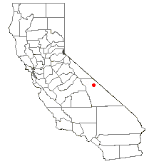
Inyo County, California
-National protected areas:* Death Valley National Park * Inyo National Forest * Manzanar National Historic Site-Major highways:* U.S. Route 6* U.S. Route 395* State Route 127* State Route 136* State Route 168* State Route 178...
, in eastern California
California
California is a state located on the West Coast of the United States. It is by far the most populous U.S. state, and the third-largest by land area...
in the southwestern United States
United States
The United States of America is a federal constitutional republic comprising fifty states and a federal district...
. It is approximately 28 miles (45 km) long and up to 10 miles (16 km) wide, with elevations varying from 2870 feet (875 m) up to 8456 feet (2575 m). The southern section of the valley is now part of the Death Valley National Park
Death Valley National Park
Death Valley National Park is a national park in the U.S. states of California and Nevada located east of the Sierra Nevada in the arid Great Basin of the United States. The park protects the northwest corner of the Mojave Desert and contains a diverse desert environment of salt-flats, sand dunes,...
- Death Valley
Death Valley
Death Valley is a desert valley located in Eastern California. Situated within the Mojave Desert, it features the lowest, driest, and hottest locations in North America. Badwater, a basin located in Death Valley, is the specific location of the lowest elevation in North America at 282 feet below...
itself lies just to the southeast. To the north is Deep Springs Valley
Deep Springs Valley
Deep Springs Valley is a high desert valley in the Inyo-White Mountains of Inyo County, California. It is east of the Owens Valley and the Sierra Nevada mountain range, and south of Fish Lake Valley, Nevada, near the California-Nevada state border....
, Fish Lake Valley, and the White Mountain Range
White Mountains (California)
The White Mountains of California are a triangular fault block mountain range facing the Sierra Nevada across the upper Owens Valley. They extend for approximately as a greatly elevated plateau about wide on the south, narrowing to a point at the north, with elevations generally increasing...
. To the east the Last Chance Range
Last Chance Range
for the mountain range of the same name in Nye County, Nevada.The Last Chance Range of California is located near the Nevada state line in eastern Inyo County in the United States....
rises over 5500 feet (1675 m) above the valley floor. To the west are the Saline Mountains, and to the southwest lies Saline Valley.
Eureka Valley is a graben
Graben
In geology, a graben is a depressed block of land bordered by parallel faults. Graben is German for ditch. Graben is used for both the singular and plural....
, like most other lower-lying areas of the Basin and Range Province. An improved gravel road crosses the valley, connecting the community of Big Pine
Big Pine, California
Big Pine is a census-designated place in Inyo County, California, United States. Big Pine is located south-southeast of Bishop, at an elevation of 3990 feet . The population was 1,756 at the 2010 census, up from 1,350 at the 2000 census...
to the northern Grapevine section of Death Valley. A 10 mile gravel road provides access to the southern end of the valley. More primitive routes exit the valley to the northwest via Soldier Pass, to the northeast via Horse Thief Pass, and to the south via Dedeckera Canyon.
The valley has two distinguishing features. Its shape alters the wind in such a way as to collect sand near its southern end, leading to the unique Eureka Dunes
Eureka Valley Sand Dunes
The Eureka Valley Sand Dunes are located in the southern part of Eureka Valley, in northern Inyo County in eastern California, in the southwestern United States...
. Also, just to the east of the dunes, the Last Chance Range climbs over 3500 feet (1070 m) as near-vertical cliffs, displaying colorful rock strata
Stratum
In geology and related fields, a stratum is a layer of sedimentary rock or soil with internally consistent characteristics that distinguish it from other layers...
.