
Eramosa Karst
Encyclopedia
The Eramosa Karst is a provincially-significant Earth Science Area of Natural and Scientific Interest
in Ontario
, Canada
, located in Stoney Creek
, a constituent community of the City of Hamilton
, and immediately south of the Niagara Escarpment
.
It exhibits sixteen different karst
ic geological features, of which seven are provincially significant, and is considered to be the best example of karst topography found in Ontario. The area is composed of parcels of land that are provincially, municipally and privately owned. It received ANSI-ES designation on February 13, 2003.
to create a new conservation area
, followed by another donation of 3.1 ha in April 2007. The City of Hamilton has also contributed in June 2007 by transferring 1.6 ha. The area opened to the public on June 20, 2008.
s. However, the Eramosa Escarpment is much smaller in height (no more than 10 metres); its crest is only occasionally defined by cliffs, which are no higher than 3 metres. Most of the bedrock
is buried by till
.
The area exhibits a great concentration of various karstic features.
s) are mostly found in its suffusion form. Suffusion dolines are depressions formed above caves and smaller cavities in unconsolidated sediments. Many dolines in the Eramosa Karst are formed by a combination of soil piping and erosion of the glacially-deposited sediments, overlying the bedrock.
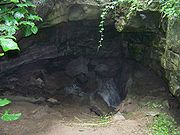 These features are created when a cave's bedrock roof collapses. Pottruff Cave's entrance is an example of such a formation.
It is planned to connect the conservation area to Felker's Falls, Mount Albion Conservation Area, and Bruce Trail
via the 10 kilometre East Mountain Loop Trail. Furthermore, a link to Olmstead Cave, located in a Hamilton park, is being considered.
Area of Natural and Scientific Interest
An Area of Natural and Scientific Interest is an official designation by the provincial Government of Ontario in Canada applied to contiguous geographical regions within the province that have geological or ecological features which are significantly representative provincially or regionally...
in Ontario
Ontario
Ontario is a province of Canada, located in east-central Canada. It is Canada's most populous province and second largest in total area. It is home to the nation's most populous city, Toronto, and the nation's capital, Ottawa....
, Canada
Canada
Canada is a North American country consisting of ten provinces and three territories. Located in the northern part of the continent, it extends from the Atlantic Ocean in the east to the Pacific Ocean in the west, and northward into the Arctic Ocean...
, located in Stoney Creek
Stoney Creek, Ontario
Stoney Creek is a community in Ontario, Canada.Note: This article will only deal with matters up to its amalgamation with Hamilton.-Geography and population:...
, a constituent community of the City of Hamilton
Hamilton, Ontario
Hamilton is a port city in the Canadian province of Ontario. Conceived by George Hamilton when he purchased the Durand farm shortly after the War of 1812, Hamilton has become the centre of a densely populated and industrialized region at the west end of Lake Ontario known as the Golden Horseshoe...
, and immediately south of the Niagara Escarpment
Niagara Escarpment
The Niagara Escarpment is a long escarpment, or cuesta, in the United States and Canada that runs westward from New York State, through Ontario, Michigan, Wisconsin and Illinois...
.
It exhibits sixteen different karst
KARST
Kilometer-square Area Radio Synthesis Telescope is a Chinese telescope project to which FAST is a forerunner. KARST is a set of large spherical reflectors on karst landforms, which are bowlshaped limestone sinkholes named after the Kras region in Slovenia and Northern Italy. It will consist of...
ic geological features, of which seven are provincially significant, and is considered to be the best example of karst topography found in Ontario. The area is composed of parcels of land that are provincially, municipally and privately owned. It received ANSI-ES designation on February 13, 2003.
Conservation area
In October 2006, Ontario donated 73 ha of land to the Hamilton Conservation AuthorityHamilton Conservation Authority
The Hamilton Conservation Authority maintains the greenspace, trails, parks and some attractions in the Hamilton, Ontario, Canada.The Hamilton Conservation Authority has managed the natural environment in partnership with the City of Hamilton and the Province of Ontario to help ensure a safe and...
to create a new conservation area
Conservation area
A conservation areas is a tract of land that has been awarded protected status in order to ensure that natural features, cultural heritage or biota are safeguarded...
, followed by another donation of 3.1 ha in April 2007. The City of Hamilton has also contributed in June 2007 by transferring 1.6 ha. The area opened to the public on June 20, 2008.
Landform
The area is crossed by the Eramosa Escarpment. It is morphologically similar to the Niagara Escarpment, as both are composed of the Lockport Formation dolostoneDolostone
Dolostone or dolomite rock is a sedimentary carbonate rock that contains a high percentage of the mineral dolomite. In old U.S.G.S. publications it was referred to as magnesian limestone. Most dolostone formed as a magnesium replacement of limestone or lime mud prior to lithification. It is...
s. However, the Eramosa Escarpment is much smaller in height (no more than 10 metres); its crest is only occasionally defined by cliffs, which are no higher than 3 metres. Most of the bedrock
Bedrock
In stratigraphy, bedrock is the native consolidated rock underlying the surface of a terrestrial planet, usually the Earth. Above the bedrock is usually an area of broken and weathered unconsolidated rock in the basal subsoil...
is buried by till
Till
thumb|right|Closeup of glacial till. Note that the larger grains in the till are completely surrounded by the matrix of finer material , and this characteristic, known as matrix support, is diagnostic of till....
.
The area exhibits a great concentration of various karstic features.
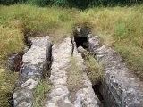
Soil pipes
These tubular cavities, a few millimetres to a few centimetres in diameter, conduct water from the surface to the karst bedrock below.Dolines
Dolines (or sinkholeSinkhole
A sinkhole, also known as a sink, shake hole, swallow hole, swallet, doline or cenote, is a natural depression or hole in the Earth's surface caused by karst processes — the chemical dissolution of carbonate rocks or suffosion processes for example in sandstone...
s) are mostly found in its suffusion form. Suffusion dolines are depressions formed above caves and smaller cavities in unconsolidated sediments. Many dolines in the Eramosa Karst are formed by a combination of soil piping and erosion of the glacially-deposited sediments, overlying the bedrock.
Karst windows
Valleys
Streams flowing through the area have formed valleys that are typical of a karstic landscape. Blind valleys are formed when a stream sinks underground. As there is no farther surface flow, such valleys ends abruptly. A half-blind valley is similar, except that a surface flow is occasionally present downstream of the sinkpoint. Dry valleys were formed prior to the development of underground stream passages, representing a former route of springs before they were diverted by sinkholes. Depending on the stage of evolution, these valleys may or may not have surface flow.Caves
Five dissolutional caves, large enough for human entry, have been identified within the area. Nexus Cave is the largest, measuring 335 metres in length, and is the 10th longest cave in Ontario.Conservation efforts
The ANSI status of the area does not imply automatic protection. The conservation area's boundaries roughly correspond to the Core Area of the ANSI. However, the Feeder Area, where the streams originate, is managed by the Ontario Realty Corporation, which intends to sell it for residential development. Local scientists and politicians urge the Ontario government to abandon its plans and incorporate these lands into the conservation area, arguing that geological and biological diversity of Eramosa Karst will be severely diminished, should the development take place.It is planned to connect the conservation area to Felker's Falls, Mount Albion Conservation Area, and Bruce Trail
Bruce Trail
The Bruce Trail is a hiking trail in southern and central Ontario, Canada.-General:The trail follows the edge of the Niagara Escarpment, one of the thirteen UNESCO World Biosphere Reserves in Canada, for almost...
via the 10 kilometre East Mountain Loop Trail. Furthermore, a link to Olmstead Cave, located in a Hamilton park, is being considered.