

Emona Anchorage
Encyclopedia
South Bay, Livingston Island
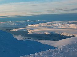
South Bay is a wide bay indenting for the south coast of Livingston Island in the South Shetland Islands, Antarctica. The bay is lying northwest of False Bay and east of Walker Bay, and is entered between Hannah Point and Miers Bluff....
, Livingston Island in the South Shetland Islands
South Shetland Islands
The South Shetland Islands are a group of Antarctic islands, lying about north of the Antarctic Peninsula, with a total area of . By the Antarctic Treaty of 1959, the Islands' sovereignty is neither recognized nor disputed by the signatories and they are free for use by any signatory for...
, Antarctica used as an anchorage for ships visiting the Bulgaria
Bulgaria
Bulgaria , officially the Republic of Bulgaria , is a parliamentary democracy within a unitary constitutional republic in Southeast Europe. The country borders Romania to the north, Serbia and Macedonia to the west, Greece and Turkey to the south, as well as the Black Sea to the east...
n base St. Kliment Ohridski
St. Kliment Ohridski Base
St. Kliment Ohridski Base is a Bulgarian Antarctic base on Livingston Island in the South Shetland Islands.The base, originally known as Sofia University Refuge, was named in 1993 "for St...
.
Emona
Emona (Burgas)
Emona is a village and seaside resort in southeast Bulgaria, situated in the Nesebar Municipality of the Burgas Province. The beach Irakli is 5 km from Emona. Emona lies close to Cape Emine. There are ruins of the ancient fortress nearby....
is the name of a village and, in the version of Emine
Cape Emine
Cape Emine is a headland located at the Bulgarian Black Sea Coast. It is located 49 miles south of Varna, 34 miles north of Burgas and 9 miles south of Obzor. It forms the tip of Stara Planina. Cape Emine is said to be Bulgaria's stormiest cape....
, a nearby cape on the Bulgarian Black Sea Coast
Bulgarian Black Sea Coast
The Bulgarian Black Sea Coast covers the entire eastern bound of Bulgaria stretching from the Romanian Black Sea resorts in the north to European Turkey in the south, along 378 km of coastline. White and golden sandy beaches occupy approximately 130 km of the 378 km long coast...
.
Details
Entered between Hespérides PointHespérides Point
Hespérides Point is a rocky point of land projecting into South Bay north-northwest of Johnsons Dock, Livingston Island in the South Shetland Islands, Antarctica and forming the southwest side of the entrance to Emona Anchorage. Surmounted by Hesperides Hill...
and Smolyan Point
Smolyan Point
Smolyan Point is located on the north-western coast of South Bay, Livingston Island in the South Shetland Islands, Antarctica forming the northwest side of the entrance to Emona Anchorage. The ice-covered point shows conspicuous radial crevasses spreading inland and ends up with a 25 m wide and 4...
, the bay is over 100 m deep at its central portion northwest by north of Spanish Point
Spanish Point (Antarctica)
Spanish Point is located on Bulgarian Beach on Hurd Peninsula, eastern Livingston Island in the South Shetland Islands, Antarctica formed by an offshoot of Spanish Knoll....
. Northeast of Smolyan Point, a nameless 710 m wide cove is indenting for 250 m behind Rongel Reef
Rongel Reef
Rongel Reef , is a moraine reef in the Emona Anchorage in the eastern parts of Livingston Island in the South Shetland Islands, Antarctica. The reef emerged during a glacier retreat in the late 20th and early 21st centuries....
, with a shoal east of that cape, and a small awash islet 550 m due northeast of it. Rongel Point
Rongel Point
Rongel Point is an ice-free tipped cape forming the east-northeast side of the entrance to the 710 m wide nameless cove indenting for 250 m the coast behind Rongel Reef on Livingston Island, Antarctica....
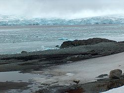
forms the east-northeast side of that cove’s entrance. The remaining northwest coast of Emona Anchorage is, with several minor disruptions, a narrow beach under the ice-cap cliff, with Pimpirev Ice Wall, an ice form in Pimpirev Glacier
Pimpirev Glacier
Pimpirev Glacier on Livingston Island drains southeastwards towards Pimpirev Beach. It is situated west of Perunika Glacier, south of Tundzha Glacier and the glacial divide between the Drake Passage and Bransfield Strait, and east of Kamchiya Glacier...
running parallelly some 100 m inland. That section of the coast is 2.15 km long, featuring a single minor point lying 3.51 km north of Hespérides Point and 1.97 km west-northwest of Aleko Point
Aleko Point
Aleko Point , also Aleko Rock, is a rocky point midway along the northeast Antarctic coast of Emona Anchorage in the east of Livingston Island, projecting 150m to the west of southwest....
. An ice sea cave located 870 m east-northeast of that point and 1.45 km northwest of Aleko Point marks the beach end and the north corner of the bay. The northeast coast except for Aleko Point is formed by Perunika Glacier
Perunika Glacier
Perunika Glacier is an 8 km long and 3 km wide roughly crescent-shaped glacier in eastern Livingston Island in the South Shetland Islands, Antarctica....
's snout, while Bulgarian Beach
Bulgarian Beach
Bulgarian Beach is a coast in the north part of Hurd Peninsula, eastern Livingston Island, extending 2.3 km from Hespérides Point to the southwest to Perunika Glacier to the northeast, and forming the southeast coast of Emona Anchorage.The beach comprises four predominantly boulder beaches,...
accounts for most of the southeast coast, featuring Vergilov Rocks
Vergilov Rocks
Vergilov Rocks are a group of rocks off Bulgarian Beach in eastern Livingston Island in the South Shetland Islands, Antarctica, consisting of one main rock and two adjacent smaller ones submerging at high water....
100 m offshore. The Emona Anchorage beaches and drifting sea ice are favoured by a fairly small number of penguins and seals, usually comprising chinstrap, gentoo and Adelie penguins, and Weddell, crabeater, leopard and incidentally fur seals.
Mapping
As a part of South Bay appears on earliest charts of the area. Detailed mapping in 1991 by the Servicio Geográfico del Ejército with bathymetry by the Instituto Hidrogràfico de la Marina, Spain. Glacier retreat from bay waters indicated by a 1991 satellite image and further regression recorded in February 1995. Bulgarian remapping of the modified coastal configuration from a ground survey made during the summer of 1995-96. The 1996, 2005 and 2009 Bulgarian mapping of Livingston Island indicated continuing glacier retreat on the northeast side of the bay.Maps
- Isla Livingston: Península Hurd. Mapa topográfico de escala 1:25 000. Madrid: Servicio Geográfico del Ejército, 1991.
- L.L. Ivanov. Livingston Island: Central-Eastern Region. Scale 1:25000 topographic map. Sofia: Antarctic Place-names Commission of Bulgaria, 1996.
- L.L. Ivanov et al. Antarctica: Livingston Island and Greenwich Island, South Shetland Islands. Scale 1:100000 topographic map. Sofia: Antarctic Place-names Commission of Bulgaria, 2005.
- L.L. Ivanov. Antarctica: Livingston Island and Greenwich, Robert, Snow and Smith Islands. Scale 1:120000 topographic map. Troyan: Manfred Wörner Foundation, 2009.