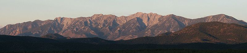
White Pine Range
Encyclopedia
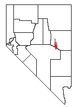
White Pine County, Nevada
White Pine County is a county located in the U.S. state of Nevada. Its population at the 2010 census was 10,030. Its county seat is Ely. It is the home of Great Basin National Park...
, in eastern Nevada
Nevada
Nevada is a state in the western, mountain west, and southwestern regions of the United States. With an area of and a population of about 2.7 million, it is the 7th-largest and 35th-most populous state. Over two-thirds of Nevada's people live in the Las Vegas metropolitan area, which contains its...
. The range runs for approximately 51 miles (82 km) from Beck Pass in the north to Currant Pass in the south. To the west of the range are the Duckwater (Shoshone
Shoshone
The Shoshone or Shoshoni are a Native American tribe in the United States with three large divisions: the Northern, the Western and the Eastern....
) tribal lands and the northern arm of large Railroad Valley
Railroad Valley
Railroad Valley is one of the Central Nevada Desert Basins in the Tonopah Basin and is ~80 miles long north-south and up to 20 miles wide, with some southern areas running southwest to northeast. The southern end of the valley begins near Gray Top Mountain and stretches north all the way to...
. To the east are Jakes Valley and the northern part of the long White River Valley
White River (Nevada)
The White River is a small and discontinuous river located in southeastern Nevada notable for several endemic species of fish.-Course:The river begins at the Great Basin Divide in the White Pine Range near Ely, where it is fed by snow melt and springs from Currant Mountain...
. To the south are the Horse and Grant
Grant Range
The Grant Range is a mountain chain in east-central Nevada in the western United States. It runs for approximately 30 miles in a generally north-south direction in northeastern Nye County. It is located south of the Horse Range and northeast of the closely associated Quinn Canyon Range. To the...
Ranges.
U.S. Route 50
U.S. Route 50 is a major east–west route of the U.S. Highway system, stretching just over from Ocean City, Maryland on the Atlantic Ocean to West Sacramento, California. Until 1972, when it was replaced by Interstate Highways west of the Sacramento area, it extended to San Francisco, near...
, the "Loneliest Highway in America", crosses the range near its northern end at Little Antelope Summit (7433 ft, 2265 m). At the southern edge of the range Highway 6
U.S. Route 6
U.S. Route 6 , also called the Grand Army of the Republic Highway, a name that honors an American Civil War veterans association, is a main route of the U.S. Highway system, running east-northeast from Bishop, California to Provincetown, Massachusetts. Until 1964, it continued south from Bishop to...
, which may be even lonelier, crosses at Currant Summit (6999 ft, 2133 m). The southern edge of the range extends into northeastern Nye County
Nye County, Nevada
-National protected areas:* Ash Meadows National Wildlife Refuge* Death Valley National Park * Humboldt-Toiyabe National Forest * Spring Mountains National Recreation Area -Demographics:...
.
Hamilton, Nevada
Hamilton is an abandoned mining town located in the White Pine Range, in western White Pine County, Nevada, USA. The town boomed in 1868 and 1869 following the discovery of rich silver deposits nearby, but the ore deposits proved shallow and by 1870 the region was already in decline...
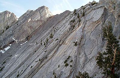
lies just south of Highway 50, and includes Mt. Hamilton (10,745 ft, 3275 m). The southern portion of the range rises to a thin limestone ridge, including Currant Mountain
Currant Mountain
Currant Mountain is the high point on the southern crest of the White Pine Range, on the border between southwest White Pine and northeast Nye Counties, in east-central Nevada in the western United States. It comprises a series of three spires on a thin limestone ridge, with the southern spire...
(11,513 ft, 3509 m), the high point of the range. Nearby are Duckwater Peak (11,188 ft, 3410 m) and White Pine Peak (10,182 ft, 3103 m). This high section of the range is protected as the Currant Mountain Wilderness Area
Currant Mountain Wilderness
The Currant Mountain Wilderness is a wilderness area in the White Pine Range of Nye County and White Pine County, in the eastern section of the state of Nevada in the western United States....
, and its eastern slopes serve as headwaters to the White River
White River (Nevada)
The White River is a small and discontinuous river located in southeastern Nevada notable for several endemic species of fish.-Course:The river begins at the Great Basin Divide in the White Pine Range near Ely, where it is fed by snow melt and springs from Currant Mountain...
. The 40013 acres (161.9 km²) White Pine Range Wilderness Area
White Pine Range Wilderness
The White Pine Range Wilderness is a wilderness area in southwestern White Pine County, in the U.S. state of Nevada.-Geography:The Wilderness lies within the Humboldt-Toiyabe National Forest and is therefore administered by the U.S...
borders the Currant Mountain Wilderness on the south.
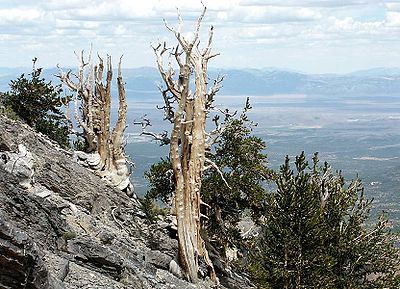
Although named after the Limber Pine
Limber Pine
The Limber Pine, Pinus flexilis, is a species of pine tree-the family Pinaceae that occurs in the mountains of the Western United States, Mexico, and Canada. It is also called Southwestern White Pine and Rocky Mountain White Pine...
, the range might better be known for its large and vigorous stand of Great Basin Bristlecone Pine
Great Basin Bristlecone Pine
Pinus longaeva, the Great Basin Bristlecone Pine, is a long-living species of tree found in the higher mountains of the southwest United States. The species is one of three closely related trees known as bristlecone pines and is sometimes known as the Intermountain or Western bristlecone pine...
s. Young and old trees alike exist at elevations above 10,000 feet, right up to the summit of Currant Mountain.