
.gif)
Eastern Avenue (Toronto)
Encyclopedia
Eastern Avenue is an east-west street in Toronto
, Canada
. It runs from just east of Parliament Street in the downtown to just west of Coxwell Avenue, near the Beaches
neighbourhood. Originally Eastern crossed the Don River
at the Old Eastern Avenue Bridge, but that bridge was disconnected in 1964. Today, Eastern's east and west halves cross the Don River north of the old alignment via a large bridge to the Don Valley Parkway
which also forks out and becomes the eastern terminus of both Richmond and Adelaide streets.
Eastern runs through what was once the heart of Toronto's most industrial area, the region just north of Toronto Harbour
and the Port Lands
area. Today most of the factories have departed. Some do remain, notably the large Weston
bakery. Several film studios have moved into the former industrial areas near Eastern and Carlaw, and this area is today billed as the Studio District. Eastern was also home to the headquarters of the Toronto chapter of the Hells Angels
, until it was raided and confiscated by police in April 2007.
At its eastern terminus it now meets up at Kingston Road
, once the main cross colonial route linking York
to the other major Upper Canada
settlement of Kingston
.
Prior to 2000, however, Eastern Avenue did not meet up up directly with Kingston Road, but at a point a few hundred feet west of the intersection of Kingston Road and Queen Street. Only with the demolition of Greenwood Racetrack was Eastern Avenue extended to flow directly into Kingston Road. The former terminus of Eastern Avenue still exists—it is the small unmarked street that runs south off Queen Street between Coxwell and Orchard Park Avenues.
In 2008 bike lanes were added to Eastern, sparking controversy regarding practicality of bike lanes on arterial roads.
Toronto
Toronto is the provincial capital of Ontario and the largest city in Canada. It is located in Southern Ontario on the northwestern shore of Lake Ontario. A relatively modern city, Toronto's history dates back to the late-18th century, when its land was first purchased by the British monarchy from...
, Canada
Canada
Canada is a North American country consisting of ten provinces and three territories. Located in the northern part of the continent, it extends from the Atlantic Ocean in the east to the Pacific Ocean in the west, and northward into the Arctic Ocean...
. It runs from just east of Parliament Street in the downtown to just west of Coxwell Avenue, near the Beaches
The Beaches
The Beaches is a neighbourhood and popular tourist destination located in Toronto, Ontario, Canada. It is located on the east side of the "Old" City of Toronto. The original boundaries of the neighbourhood are from Fallingbrook Avenue on the east to Kingston Road on the north, to Woodbine Avenue...
neighbourhood. Originally Eastern crossed the Don River
Don River (Toronto)
The Don River is one of two rivers bounding the original settled area of Toronto, Ontario along the shore of Lake Ontario, the other being the Humber River to the west. The Don is formed from two rivers, the East and West Branches, that meet about north of Lake Ontario while flowing southward into...
at the Old Eastern Avenue Bridge, but that bridge was disconnected in 1964. Today, Eastern's east and west halves cross the Don River north of the old alignment via a large bridge to the Don Valley Parkway
Don Valley Parkway
The Don Valley Parkway is a controlled-access six-lane municipal expressway in Toronto connecting the Gardiner Expressway in downtown Toronto with Ontario Highway 401, the Macdonald–Cartier Freeway. North of Highway 401, it continues as Ontario Highway 404. The parkway runs through...
which also forks out and becomes the eastern terminus of both Richmond and Adelaide streets.
Eastern runs through what was once the heart of Toronto's most industrial area, the region just north of Toronto Harbour
Toronto Harbour
Toronto Harbour or Toronto Bay is a bay on the north shore of Lake Ontario, in Toronto, Ontario, Canada. It is a natural harbour, protected from Lake Ontario waves by the Toronto Islands. It is a commercial port on the Great Lakes as well as a recreational harbour...
and the Port Lands
Port Lands
The Port Lands of Toronto, Ontario, Canada are an industrial and recreational neighbourhood located about 5 kilometres south-east of downtown, located on the former Don River delta and most of Ashbridge's Bay....
area. Today most of the factories have departed. Some do remain, notably the large Weston
George Weston Limited
George Weston Limited , often referred to as Weston or Weston's, is Canada's largest food processing and distribution company. Founded by George Weston in 1882, the company today consists of Weston Foods, a wholly owned subsidiary, and Loblaw Companies Limited, the country's largest supermarket...
bakery. Several film studios have moved into the former industrial areas near Eastern and Carlaw, and this area is today billed as the Studio District. Eastern was also home to the headquarters of the Toronto chapter of the Hells Angels
Hells Angels
The Hells Angels Motorcycle Club is a worldwide one-percenter motorcycle gang and organized crime syndicate whose members typically ride Harley-Davidson motorcycles. In the United States and Canada, the Hells Angels are incorporated as the Hells Angels Motorcycle Corporation. Their primary motto...
, until it was raided and confiscated by police in April 2007.
At its eastern terminus it now meets up at Kingston Road
Kingston Road (Toronto)
Kingston Road is the southernmost major road along the eastern portion of Toronto, specifically in the districts of East York and Scarborough. Until 1998, it formed a significant portion of Highway 2...
, once the main cross colonial route linking York
York, Upper Canada
York was the name of Old Toronto between 1793 and 1834. It was the second capital of Upper Canada.- History :The town was established in 1793 by Governor John Graves Simcoe, with a new 'Fort York' on the site of the last French 'Fort Toronto'...
to the other major Upper Canada
Upper Canada
The Province of Upper Canada was a political division in British Canada established in 1791 by the British Empire to govern the central third of the lands in British North America and to accommodate Loyalist refugees from the United States of America after the American Revolution...
settlement of Kingston
Kingston, Ontario
Kingston, Ontario is a Canadian city located in Eastern Ontario where the St. Lawrence River flows out of Lake Ontario. Originally a First Nations settlement called "Katarowki," , growing European exploration in the 17th Century made it an important trading post...
.
Prior to 2000, however, Eastern Avenue did not meet up up directly with Kingston Road, but at a point a few hundred feet west of the intersection of Kingston Road and Queen Street. Only with the demolition of Greenwood Racetrack was Eastern Avenue extended to flow directly into Kingston Road. The former terminus of Eastern Avenue still exists—it is the small unmarked street that runs south off Queen Street between Coxwell and Orchard Park Avenues.
Transportation
A number of north-south buses use Eastern as the street they loop along before returning northwards. The include the 22 Coxwell, 31 Greenwood, and 72 Pape.In 2008 bike lanes were added to Eastern, sparking controversy regarding practicality of bike lanes on arterial roads.
Landmarks
Landmarks and notable sites along Eastern from west to east| Landmark | Cross street | Notes | Image |
|---|---|---|---|
| Inglenook Community High School Inglenook Community High School Inglenook Community High School is an alternative high school which offers only senior courses. It is housed in an historical building designed by William George Storm in Corktown, in downtown Toronto, Ontario, Canada. The school has, on average, one hundred students and six teachers... |
Cherry St | Historic school building | 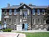 |
| West Don Lands West Don Lands The West Don Lands are the site of a planned neighbourhood under construction in Toronto, Ontario, Canada. The area is bordered by the Don River, King Street, Parliament Street and the rail line adjacent to the Gardiner Expressway.... |
River St | Abandoned industrial area under redevelopment | 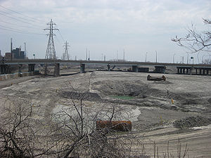 |
| Old Eastern Avenue Bridge | Don River | Abandoned bridge | 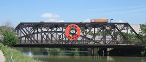 |
| Sunlight Park | Don River | First baseball park in Toronto, demolished 1896 | |
| Broadview Lofts Broadview Lofts Broadview Lofts is a former warehouse that has been converted into condominiums in Toronto, Canada. It is located on Broadview Avenue just south of Queen Street East. This is a formerly industrial area, that has in recent years seen a number of condominium projects.The building was originally... |
Broadview | Former warehouse converted into lofts | |
| Toronto Film Studios | Carlaw | ||
| Russell Carhouse | Greenwood | TTC streetcar yard | |
| South Central sorting plant | Greenwood | Main Canada Post Canada Post Canada Post Corporation, known more simply as Canada Post , is the Canadian crown corporation which functions as the country's primary postal operator... facility for central Toronto |
|
| Greenwood Raceway Greenwood Raceway Greenwood Raceway is a defunct horse racing facility in Toronto.Inaugurated in 1874 as Woodbine Race Course at the foot of Woodbine Avenue and Lake Ontario, it was owned and operated by two gentlemen named Pardee and Howell. Within a few years financial problems resulted in the property reverting... |
Greenwood | Racetrack demolished in the 1990s |