
East Raynham
Encyclopedia
East Raynham is a village in the county of Norfolk
. It is located on the A1065
some 4 miles (6.4 km) south-west of from Fakenham
. The River Wensum
flows close to the village. The village can trace its origins back and before the Domesday survey of 1086 when it was known as Reinham.
and South Raynham
, a large area of farmland known as Raynham Park, which the Raynham villages and 17th century Raynham Hall border.
 Raynham Hall
is a rectangular mansion built of brick and stone dressings. Work commenced in 1619 and was completed in 1630. It is the seat of the Townshend family, and is owned today by the 7th Marquis Townshend.
. The 2nd Viscount, " Turnip " Townshend is buried here. In 2002 the ring of eight bells
was restored and augmented. The The Queen
paid a private visit to the church in July 2002.
, water meadows, arable land
and historic buildings, almost entirely on the Raynham estate.
Norfolk
Norfolk is a low-lying county in the East of England. It has borders with Lincolnshire to the west, Cambridgeshire to the west and southwest and Suffolk to the south. Its northern and eastern boundaries are the North Sea coast and to the north-west the county is bordered by The Wash. The county...
. It is located on the A1065
A1065 road
The A1065 is a main road in the English region of East Anglia. It provides the principal road connection to parts of the west and north of the county of Norfolk from Newmarket and points south of there, including London...
some 4 miles (6.4 km) south-west of from Fakenham
Fakenham
Fakenham is a town and civil parish in Norfolk, England. It is situated on the River Wensum, some north east of King's Lynn, south west of Cromer, and north west of Norwich....
. The River Wensum
River Wensum
The River Wensum is a chalk fed river in Norfolk, England and a tributary of the River Yare despite being the larger of the two rivers. The complete river is a designated Site of Special Scientific Interest and Special Area of Conservation ....
flows close to the village. The village can trace its origins back and before the Domesday survey of 1086 when it was known as Reinham.
The Raynhams
Today, The Raynhams would cover the names of three villages East, West RaynhamWest Raynham
West Raynham is a village in the county of Norfolk. Located close to the A1065 road, some 5 miles SW of Fakenham and is the largest village on the Raynham estate. The river Wensum flows nearby...
and South Raynham
South Raynham, Norfolk
South Raynham is a village in the county of Norfolk. It is situated on the A1065 road some SW of Fakenham. The River Wensum flows nearby. The village can trace its origins back and before the Domesday survey of 1086 when the village was known as Reinham....
, a large area of farmland known as Raynham Park, which the Raynham villages and 17th century Raynham Hall border.
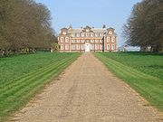
Raynham Hall
Raynham Hall
Raynham Hall is a country house in Norfolk, England. For 300 years it has been the seat of the Townshend family. The hall gave its name to the area, known as The Raynhams, and is reported to be haunted, providing the scene for possibly the most famous ghost photo of all time, the famous Brown Lady...
is a rectangular mansion built of brick and stone dressings. Work commenced in 1619 and was completed in 1630. It is the seat of the Townshend family, and is owned today by the 7th Marquis Townshend.
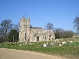
The Church of St Mary
The church stands in the park of Raynham Hall. It was rebuilt in 1868 but retains the 15th century Easter SepulchreSepulchre
The rock-cut tombs in ancient Israel are a group of hundreds of rock-cut tombs constructed in Israel in ancient times. They were cut into the rock, sometimes with elaborate facades and multiple burial chambers. Some are free-standing, but most are caves. Each tomb typically belonged to a...
. The 2nd Viscount, " Turnip " Townshend is buried here. In 2002 the ring of eight bells
Ring of bells
"Ring of bells" is a term most often applied to a set of bells hung in the English style, typically for change ringing...
was restored and augmented. The The Queen
Elizabeth II of the United Kingdom
Elizabeth II is the constitutional monarch of 16 sovereign states known as the Commonwealth realms: the United Kingdom, Canada, Australia, New Zealand, Jamaica, Barbados, the Bahamas, Grenada, Papua New Guinea, the Solomon Islands, Tuvalu, Saint Lucia, Saint Vincent and the Grenadines, Belize,...
paid a private visit to the church in July 2002.
Recreation
Much of the area can be visited by a circular walk, which takes in mixed woodlandWoodland
Ecologically, a woodland is a low-density forest forming open habitats with plenty of sunlight and limited shade. Woodlands may support an understory of shrubs and herbaceous plants including grasses. Woodland may form a transition to shrubland under drier conditions or during early stages of...
, water meadows, arable land
Arable land
In geography and agriculture, arable land is land that can be used for growing crops. It includes all land under temporary crops , temporary meadows for mowing or pasture, land under market and kitchen gardens and land temporarily fallow...
and historic buildings, almost entirely on the Raynham estate.