
South Raynham, Norfolk
Encyclopedia
South Raynham is a village in the county of Norfolk
. It is situated on the A1065 road
some 5 miles (8 km) SW of Fakenham
. The River Wensum
flows nearby. The village can trace its origins back and before the Domesday survey of 1086 when the village was known as Reinham.
, West
, South Raynham and a large area of park and farmland known as Raynham Park, which the Raynham villages and the 17th century Raynham Hall border.
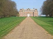 Raynham Hall
is a rectangular mansion built of brick and stone dressings. Work commenced in 1619 and was completed in 1630. It is the seat of the Townshend family, and is owned today by the 7th Marquis Townshend.
and freestone
dressings in the Decorated and Perpendicular style of architecture. The most outstanding feature of the church is the mensa
, or altar stone. Pevsner
believed it might be 12th century, but may be older.
, water meadows, arable land
, and historic buildings, almost entirely on the Raynham estate.
Norfolk
Norfolk is a low-lying county in the East of England. It has borders with Lincolnshire to the west, Cambridgeshire to the west and southwest and Suffolk to the south. Its northern and eastern boundaries are the North Sea coast and to the north-west the county is bordered by The Wash. The county...
. It is situated on the A1065 road
A1065 road
The A1065 is a main road in the English region of East Anglia. It provides the principal road connection to parts of the west and north of the county of Norfolk from Newmarket and points south of there, including London...
some 5 miles (8 km) SW of Fakenham
Fakenham
Fakenham is a town and civil parish in Norfolk, England. It is situated on the River Wensum, some north east of King's Lynn, south west of Cromer, and north west of Norwich....
. The River Wensum
River Wensum
The River Wensum is a chalk fed river in Norfolk, England and a tributary of the River Yare despite being the larger of the two rivers. The complete river is a designated Site of Special Scientific Interest and Special Area of Conservation ....
flows nearby. The village can trace its origins back and before the Domesday survey of 1086 when the village was known as Reinham.
The Raynhams
Today, The Raynhams would cover the names of three villages EastEast Raynham
East Raynham is a village in the county of Norfolk. It is located on the A1065 some south-west of from Fakenham. The River Wensum flows close to the village...
, West
West Raynham
West Raynham is a village in the county of Norfolk. Located close to the A1065 road, some 5 miles SW of Fakenham and is the largest village on the Raynham estate. The river Wensum flows nearby...
, South Raynham and a large area of park and farmland known as Raynham Park, which the Raynham villages and the 17th century Raynham Hall border.
Raynham Hall
Raynham Hall
Raynham Hall is a country house in Norfolk, England. For 300 years it has been the seat of the Townshend family. The hall gave its name to the area, known as The Raynhams, and is reported to be haunted, providing the scene for possibly the most famous ghost photo of all time, the famous Brown Lady...
is a rectangular mansion built of brick and stone dressings. Work commenced in 1619 and was completed in 1630. It is the seat of the Townshend family, and is owned today by the 7th Marquis Townshend.
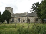
The Church of St Martin
The Church of St Martin dates back to the 14th century and is built from flintFlint
Flint is a hard, sedimentary cryptocrystalline form of the mineral quartz, categorized as a variety of chert. It occurs chiefly as nodules and masses in sedimentary rocks, such as chalks and limestones. Inside the nodule, flint is usually dark grey, black, green, white, or brown in colour, and...
and freestone
Freestone
A freestone is a stone used in masonry for molding, tracery and other replication work required to be worked with the chisel. The freestone must be fine-grained, uniform and soft enough to be cut easily without shattering or splitting. Some sources say that the stone has no grain, but this is...
dressings in the Decorated and Perpendicular style of architecture. The most outstanding feature of the church is the mensa
Altar
An altar is any structure upon which offerings such as sacrifices are made for religious purposes. Altars are usually found at shrines, and they can be located in temples, churches and other places of worship...
, or altar stone. Pevsner
Nikolaus Pevsner
Sir Nikolaus Bernhard Leon Pevsner, CBE, FBA was a German-born British scholar of history of art and, especially, of history of architecture...
believed it might be 12th century, but may be older.
Recreation
Much of the area can be visited by a circular walk, which takes in mixed woodlandWoodland
Ecologically, a woodland is a low-density forest forming open habitats with plenty of sunlight and limited shade. Woodlands may support an understory of shrubs and herbaceous plants including grasses. Woodland may form a transition to shrubland under drier conditions or during early stages of...
, water meadows, arable land
Arable land
In geography and agriculture, arable land is land that can be used for growing crops. It includes all land under temporary crops , temporary meadows for mowing or pasture, land under market and kitchen gardens and land temporarily fallow...
, and historic buildings, almost entirely on the Raynham estate.