
East Pikeland Township, Pennsylvania
Encyclopedia
East Pikeland Township is a township in Chester County
, Pennsylvania
, United States
. The population was 7,079 at the 2010 census.
to Joseph Pike from County Cork
, Ireland
, in 1705. It was eventually sold by Pike's descendants and in 1838 was split in two parts, East Pikeland and West Pikeland.
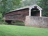
Mr. E. Kimber established the French Creek Boarding School for Girls in the 1830s and gave his name to the Village of Kimberton. East Pikeland today retains over 150 historically significant structures and sites. Those located in the historic Kimberton Village are the Kimberton Inn, the girls' school, Chrisman's Mill (now the Kimberton Post Office), the Kimberton Train Station and Pennypackers Mill. The Zion Lutheran Church on Route 724 holds the distinction of being the second oldest Lutheran Church in the United States; and the Rapps Dam Covered Bridge and the Silver Bridge
iron bridge on Hares Hill Road both have historic significance.
East Pikeland was directly involved in the Revolutionary War, especially from 1775 through 1778, and most heavily during the "Philadelphia Campaign" in 1777 and 1778. It was a source of provisions for the Army
from its farms, mills and cottage industries. Military importance came in 1775 with the authorization by the Committee of Safety in Philadelphia from the Continental Powder Mill, and the site chosen was at Rapps Dam on French Creek. The mill was a key element in a system of munitions supply that involved the Warwick and Reading iron furnaces near the headwaters of French Creek, which together with other furnaces such as Hopewell produced cannon and ammunition for Washington. The prime location of the mill on the creek with its long millrace was not forgotten after the war. Some of the mill buildings were reconstructed and over the next 150 years, continued to operate variously as oil, saw, grist and spoke mills.
East Pikeland Township has seen considerable change since the early part of the 20th century. The area around Kimberton saw expanded housing areas, as did the corridors near Routes 23
& 724
. Only the main roads were paved, according to a 1938 map. The reason for the growth in the township over the years has been an influx of population that has found East Pikeland Township an attractive and practical place to live. The suburbanization of the township, as most areas, occurred as the availability of automobiles made the general population mobile. In 1940, the township population was 976. Space to house the ever-increasing population came from the conversion of lands that had traditionally been dairy or wheat farms. Although some farms remain today, the predominant land use pattern in the central portion of the township is residential. The spread of suburban development has occurred primarily in the French Creek valley, along Cold Stream Road. Also occurring since World War II has been the development of townhouse complexes, shopping centers and industrial sites, such as the Cromby Power Station (PECO
) and shopping centers along Routes 23
& 724
. The closing of the remaining one and two room school houses occurred in the 1950s, in favor of the regional school system.
 East Pikeland Township is a township of the second class operating under the Pennsylvania Second Class Township Code. The Board of Supervisors is the governing body, with three members elected at large by the voters for staggered six-year terms. They are responsible for both the legislative and executive functions of the township. The township manager is appointed by the board and is responsible for the day-to-day business activities of the township. The manager coordinates the work of all operating departments and is directly responsible to the Board of Supervisors.
, the township has a total area of 8.9 square miles (23.1 km²), of which, 8.8 square miles (22.8 km²) of it is land and 0.1 square mile (0.258998811 km²) of it (1.23%) is water.
of 2000, there were 6,551 people, 2,530 households, and 1,834 families residing in the township. The population density
was 745.1 people per square mile (287.8/km²). There were 2,604 housing units at an average density of 296.2/sq mi (114.4/km²). The racial makeup of the township was 96.26% White, 1.36% African American, 0.08% Native American, 1.72% Asian, 0.03% Pacific Islander, 0.15% from other races
, and 0.40% from two or more races. Hispanic or Latino of any race were 0.69% of the population.
There were 2,530 households out of which 33.6% had children under the age of 18 living with them, 63.8% were married couples
living together, 5.7% had a female householder with no husband present, and 27.5% were non-families. 23.6% of all households were made up of individuals and 7.6% had someone living alone who was 65 years of age or older. The average household size was 2.58 and the average family size was 3.07.
In the township the population was spread out with 25.8% under the age of 18, 4.2% from 18 to 24, 31.5% from 25 to 44, 26.0% from 45 to 64, and 12.4% who were 65 years of age or older. The median age was 39 years. For every 100 females there were 93.6 males. For every 100 females age 18 and over, there were 90.8 males.
The median income for a household in the township was $72,850, and the median income for a family was $86,343. Males had a median income of $53,017 versus $40,500 for females. The per capita income
for the township was $31,774. About 0.5% of families and 1.8% of the population were below the poverty line, including 1.0% of those under age 18 and 1.2% of those age 65 or over.
Chester County, Pennsylvania
-State parks:*French Creek State Park*Marsh Creek State Park*White Clay Creek Preserve-Demographics:As of the 2010 census, the county was 85.5% White, 6.1% Black or African American, 0.2% Native American or Alaskan Native, 3.9% Asian, 0.0% Native Hawaiian, 1.8% were two or more races, and 2.4% were...
, Pennsylvania
Pennsylvania
The Commonwealth of Pennsylvania is a U.S. state that is located in the Northeastern and Mid-Atlantic regions of the United States. The state borders Delaware and Maryland to the south, West Virginia to the southwest, Ohio to the west, New York and Ontario, Canada, to the north, and New Jersey to...
, United States
United States
The United States of America is a federal constitutional republic comprising fifty states and a federal district...
. The population was 7,079 at the 2010 census.
History
Pike's Land was the first name given to a grant of 10000 acres (40 km²) by William PennWilliam Penn
William Penn was an English real estate entrepreneur, philosopher, and founder of the Province of Pennsylvania, the English North American colony and the future Commonwealth of Pennsylvania. He was an early champion of democracy and religious freedom, notable for his good relations and successful...
to Joseph Pike from County Cork
County Cork
County Cork is a county in Ireland. It is located in the South-West Region and is also part of the province of Munster. It is named after the city of Cork . Cork County Council is the local authority for the county...
, Ireland
Ireland
Ireland is an island to the northwest of continental Europe. It is the third-largest island in Europe and the twentieth-largest island on Earth...
, in 1705. It was eventually sold by Pike's descendants and in 1838 was split in two parts, East Pikeland and West Pikeland.
Mr. E. Kimber established the French Creek Boarding School for Girls in the 1830s and gave his name to the Village of Kimberton. East Pikeland today retains over 150 historically significant structures and sites. Those located in the historic Kimberton Village are the Kimberton Inn, the girls' school, Chrisman's Mill (now the Kimberton Post Office), the Kimberton Train Station and Pennypackers Mill. The Zion Lutheran Church on Route 724 holds the distinction of being the second oldest Lutheran Church in the United States; and the Rapps Dam Covered Bridge and the Silver Bridge
Hares Hill Road Bridge
The Hares Hill Road Bridge is a single-span, wrought iron, arched-shaped lattice girder bridge. It was built in 1869 in Chester County, Pennsylvania by Moseley Iron Bridge and Roof Company and is the only known surviving example of this kind. The bridge crosses French Creek, a Scenic River, and...
iron bridge on Hares Hill Road both have historic significance.
East Pikeland was directly involved in the Revolutionary War, especially from 1775 through 1778, and most heavily during the "Philadelphia Campaign" in 1777 and 1778. It was a source of provisions for the Army
Army
An army An army An army (from Latin arma "arms, weapons" via Old French armée, "armed" (feminine), in the broadest sense, is the land-based military of a nation or state. It may also include other branches of the military such as the air force via means of aviation corps...
from its farms, mills and cottage industries. Military importance came in 1775 with the authorization by the Committee of Safety in Philadelphia from the Continental Powder Mill, and the site chosen was at Rapps Dam on French Creek. The mill was a key element in a system of munitions supply that involved the Warwick and Reading iron furnaces near the headwaters of French Creek, which together with other furnaces such as Hopewell produced cannon and ammunition for Washington. The prime location of the mill on the creek with its long millrace was not forgotten after the war. Some of the mill buildings were reconstructed and over the next 150 years, continued to operate variously as oil, saw, grist and spoke mills.
East Pikeland Township has seen considerable change since the early part of the 20th century. The area around Kimberton saw expanded housing areas, as did the corridors near Routes 23
Pennsylvania Route 23
Pennsylvania Route 23 is a state highway in southeastern Pennsylvania. The route begins at Pennsylvania Route 441 in Marietta and heads east to U.S. Route 1 in Philadelphia.-Marietta to Valley Forge:...
& 724
Pennsylvania Route 724
Pennsylvania Route 724 is a road spanning from Sinking Spring, Pennsylvania to Phoenixville, Pennsylvania. 724 travels through the counties of Berks and Chester...
. Only the main roads were paved, according to a 1938 map. The reason for the growth in the township over the years has been an influx of population that has found East Pikeland Township an attractive and practical place to live. The suburbanization of the township, as most areas, occurred as the availability of automobiles made the general population mobile. In 1940, the township population was 976. Space to house the ever-increasing population came from the conversion of lands that had traditionally been dairy or wheat farms. Although some farms remain today, the predominant land use pattern in the central portion of the township is residential. The spread of suburban development has occurred primarily in the French Creek valley, along Cold Stream Road. Also occurring since World War II has been the development of townhouse complexes, shopping centers and industrial sites, such as the Cromby Power Station (PECO
Exelon
Exelon Corporation is an electricity generating and distributing company headquartered in the Chase Tower in the Chicago Loop area of Chicago. It was created in October, 2000 by the merger of PECO Energy Company and Unicom, of Philadelphia and Chicago respectively. Unicom owned Commonwealth Edison...
) and shopping centers along Routes 23
Pennsylvania Route 23
Pennsylvania Route 23 is a state highway in southeastern Pennsylvania. The route begins at Pennsylvania Route 441 in Marietta and heads east to U.S. Route 1 in Philadelphia.-Marietta to Valley Forge:...
& 724
Pennsylvania Route 724
Pennsylvania Route 724 is a road spanning from Sinking Spring, Pennsylvania to Phoenixville, Pennsylvania. 724 travels through the counties of Berks and Chester...
. The closing of the remaining one and two room school houses occurred in the 1950s, in favor of the regional school system.
Geography
According to the United States Census BureauUnited States Census Bureau
The United States Census Bureau is the government agency that is responsible for the United States Census. It also gathers other national demographic and economic data...
, the township has a total area of 8.9 square miles (23.1 km²), of which, 8.8 square miles (22.8 km²) of it is land and 0.1 square mile (0.258998811 km²) of it (1.23%) is water.
Demographics
As of the censusCensus
A census is the procedure of systematically acquiring and recording information about the members of a given population. It is a regularly occurring and official count of a particular population. The term is used mostly in connection with national population and housing censuses; other common...
of 2000, there were 6,551 people, 2,530 households, and 1,834 families residing in the township. The population density
Population density
Population density is a measurement of population per unit area or unit volume. It is frequently applied to living organisms, and particularly to humans...
was 745.1 people per square mile (287.8/km²). There were 2,604 housing units at an average density of 296.2/sq mi (114.4/km²). The racial makeup of the township was 96.26% White, 1.36% African American, 0.08% Native American, 1.72% Asian, 0.03% Pacific Islander, 0.15% from other races
Race (United States Census)
Race and ethnicity in the United States Census, as defined by the Federal Office of Management and Budget and the United States Census Bureau, are self-identification data items in which residents choose the race or races with which they most closely identify, and indicate whether or not they are...
, and 0.40% from two or more races. Hispanic or Latino of any race were 0.69% of the population.
There were 2,530 households out of which 33.6% had children under the age of 18 living with them, 63.8% were married couples
Marriage
Marriage is a social union or legal contract between people that creates kinship. It is an institution in which interpersonal relationships, usually intimate and sexual, are acknowledged in a variety of ways, depending on the culture or subculture in which it is found...
living together, 5.7% had a female householder with no husband present, and 27.5% were non-families. 23.6% of all households were made up of individuals and 7.6% had someone living alone who was 65 years of age or older. The average household size was 2.58 and the average family size was 3.07.
In the township the population was spread out with 25.8% under the age of 18, 4.2% from 18 to 24, 31.5% from 25 to 44, 26.0% from 45 to 64, and 12.4% who were 65 years of age or older. The median age was 39 years. For every 100 females there were 93.6 males. For every 100 females age 18 and over, there were 90.8 males.
The median income for a household in the township was $72,850, and the median income for a family was $86,343. Males had a median income of $53,017 versus $40,500 for females. The per capita income
Per capita income
Per capita income or income per person is a measure of mean income within an economic aggregate, such as a country or city. It is calculated by taking a measure of all sources of income in the aggregate and dividing it by the total population...
for the township was $31,774. About 0.5% of families and 1.8% of the population were below the poverty line, including 1.0% of those under age 18 and 1.2% of those age 65 or over.
Vital Statistics
- Township Roads - 37.49 miles (60.33 km)
- State Roads - 13.32 miles (21.44 km)
- Households - 2,530
- School District - Phoenixville Area