
East Greenwich, Rhode Island
Encyclopedia
East Greenwich is a town
in and the county seat
of Kent County
, Rhode Island
, United States. The population was 13,146 at the 2010 census
. East Greenwich is the wealthiest municipality within the state of Rhode Island.
Formed in 1677 it was named for Greenwich, England. It was renamed Dedford in 1686 but reverted to its original name in 1689. In 1741 the more rural western three-quarters of the town was set off as West Greenwich, the remaining quarter of it thenceforth being called East Greenwich.
Until 1854, it was one of the five state capitals for Rhode Island. The General Assembly, when meeting in East Greenwich, used the local courthouse
, which is today the town hall.
, meeting at East Greenwich, passed a resolution, which created the first formal, governmentally authorized navy in the Western Hemisphere:
“It is voted and resolved, that the committee of safety be, and they are hereby, directed to charter two suitable vessels, for the use of the colony, and fit out the same in the best manner, to protect the trade of this colony...
“That the largest of the said vessels be manned with eighty men, exclusive of officers; and be equipped with ten guns, four-pounders; fourteen swivel guns, a sufficient number of small arms, and all necessary warlike stores.
“That the small vessel be manned with a number not exceeding thirty men.
“That the whole be included in the number of fifteen hundred men, ordered to be raised in this colony...
“That they receive the same bounty and pay as the land forces...”
Wasting no time, on 12 June 1775, the same day as the above resolution, Governor Nicholas Cooke
signed orders addressed to “Captain Abraham Whipple
, commander of the Sloop Katy, and commodore of the armed vessels employed by the government…”
A number of other towns also claim to be the birthplace of the American Navy
, but none are as early, and none involve specific government authorization.
From 1802 to 1943 the East Greenwich Academy
(Kent Academy), a prominent boarding school, operated in the town.
, the town has a total area of 16.71 square miles (43.3 km²), of which, 16.58 square miles (42.9 km²) is land and 0.14 square mile (0.3625983354 km²) is water. Division Street forms the border of the town of Warwick
to the north and west until Route 2. Greenwich Cove, an arm of the Greenwich Bay
and mouth of the Maskerchug River
, is the eastern most part of the town. Four hills roll progressively up to the border of West Greenwich
, and Frenchtown Road is a rough reference to the southern boundary of North Kingstown
.
There are six East Greenwich public schools. The schools are:
East Greenwich School Committee (2009–2010)
The new park is called scallop town park, despite the fact it is not part of historical scallop town, another name for the waterfront in early days. The true scallop town resides from the town dock, down past the clubs to Fin's Marina. Originally being old small shanties of the local scallop fishermen. It used to be the section of East Greenwich Island which due to erosion has joined with the rest of the town. The water went up to Duke Street the waterfront today, was all marsh.
There is an account from one of the town's many historians, that during the Revolutionary war, a ship anchored in East Greenwich Cove, and rowed up to what is now Duke street and set off running to make a meeting with Brigadier General James Mitchell Varnum at the Varnum armory, and then sent off to run the message to him at his home, known today as the Varnum house.
of 2000, there were 12,948 people, 4,960 households, and 3,541 families residing in the town. The population density
was 781.0 people per square mile (301.5/km²). There were 5,226 housing units at an average density of 315.2 per square mile (121.7/km²). The racial makeup of the town was 95.64% White, 0.69% African American, 0.06% Native American, 2.50% Asian, 0.01% Pacific Islander, 0.29% from other races
, and 0.82% from two or more races. Hispanic or Latino of any race were 0.90% of the population.
There were 4,960 households out of which 36.2% had children under the age of 18 living with them, 61.5% were married couples
living together, 7.9% had a female householder with no husband present, and 28.6% were non-families. 24.2% of all households were made up of individuals and 9.7% had someone living alone who was 65 years of age or older. The average household size was 2.58 and the average family size was 3.12.
In the town the population was spread out with 27.5% under the age of 18, 4.6% from 18 to 24, 26.6% from 25 to 44, 27.7% from 45 to 64, and 13.6% who were 65 years of age or older. The median age was 40 years. For every 100 females there were 93.8 males. For every 100 females age 18 and over, there were 89.5 males.
The median income for a household in the town was $70,063, and the median income for a family was $90,221. Males had a median income of $71,578 versus $40,934 for females. The per capita income
for the town was $38,593. About 2.5% of families and 4.7% of the population were below the poverty line, including 4.1% of those under age 18 and 7.0% of those age 66 or over.
East Greenwich and the adjacent Warwick neighborhoods of Cowesett and Potowamut are served by several media outlets: East Greenwich Patch (daily), The East Greenwich Pendulum (weekly), The North East Independent (weekly) and East Greenwich magazine (monthly) also serve the area.
New England town
The New England town is the basic unit of local government in each of the six New England states. Without a direct counterpart in most other U.S. states, New England towns are conceptually similar to civil townships in other states, but are incorporated, possessing powers like cities in other...
in and the county seat
County seat
A county seat is an administrative center, or seat of government, for a county or civil parish. The term is primarily used in the United States....
of Kent County
Kent County, Rhode Island
-Demographics:As of the census of 2000, there were 167,090 people, 67,320 households, and 44,969 families residing in the county. The population density was 982 people per square mile . There were 70,365 housing units at an average density of 414 per square mile...
, Rhode Island
Rhode Island
The state of Rhode Island and Providence Plantations, more commonly referred to as Rhode Island , is a state in the New England region of the United States. It is the smallest U.S. state by area...
, United States. The population was 13,146 at the 2010 census
United States Census, 2010
The Twenty-third United States Census, known as Census 2010 or the 2010 Census, is the current national census of the United States. National Census Day was April 1, 2010 and is the reference date used in enumerating individuals...
. East Greenwich is the wealthiest municipality within the state of Rhode Island.
Formed in 1677 it was named for Greenwich, England. It was renamed Dedford in 1686 but reverted to its original name in 1689. In 1741 the more rural western three-quarters of the town was set off as West Greenwich, the remaining quarter of it thenceforth being called East Greenwich.
Until 1854, it was one of the five state capitals for Rhode Island. The General Assembly, when meeting in East Greenwich, used the local courthouse
Kent County Courthouse
The Kent County Courthouse is a historic court building at 127 Main Street in East Greenwich, Rhode Island, United States.The courthouse was built in 1803 and added to the National Register of Historic Places in 1970.-References:...
, which is today the town hall.
Birthplace of the Navy
On 12 June 1775, the Rhode Island General AssemblyRhode Island General Assembly
The State of Rhode Island General Assembly is the state legislature of the U.S. state of Rhode Island. A bicameral body, it is composed of the lower Rhode Island House of Representatives with 75 representatives, and the upper Rhode Island Senate with 38 senators...
, meeting at East Greenwich, passed a resolution, which created the first formal, governmentally authorized navy in the Western Hemisphere:
“It is voted and resolved, that the committee of safety be, and they are hereby, directed to charter two suitable vessels, for the use of the colony, and fit out the same in the best manner, to protect the trade of this colony...
“That the largest of the said vessels be manned with eighty men, exclusive of officers; and be equipped with ten guns, four-pounders; fourteen swivel guns, a sufficient number of small arms, and all necessary warlike stores.
“That the small vessel be manned with a number not exceeding thirty men.
“That the whole be included in the number of fifteen hundred men, ordered to be raised in this colony...
“That they receive the same bounty and pay as the land forces...”
Wasting no time, on 12 June 1775, the same day as the above resolution, Governor Nicholas Cooke
Nicholas Cooke
Nicholas Cooke was a governor of the Colony of Rhode Island and Providence Plantations during the American Revolutionary War, and after Rhode Island became a state, he continued in this position to become the first Governor of the State of Rhode Island. Born in the maritime town of Providence, he...
signed orders addressed to “Captain Abraham Whipple
Abraham Whipple
Abraham Whipple was an American revolutionary naval commander in the Continental Navy. Whipple was born near Providence, Rhode Island and chose to be a seafarer early in his life. He embarked upon a career in the lucrative West Indies trade, working for Moses and John Brown...
, commander of the Sloop Katy, and commodore of the armed vessels employed by the government…”
A number of other towns also claim to be the birthplace of the American Navy
History of the United States Navy
The history of the United States Navy divides into two major periods: the "Old Navy", a small but respected force of sailing ships that was also notable for innovation in the use of ironclads during the American Civil War, and the "New Navy", the result of a modernization effort that began in the...
, but none are as early, and none involve specific government authorization.
From 1802 to 1943 the East Greenwich Academy
East Greenwich Academy
The East Greenwich Academy was a private Methodist boarding school in East Greenwich, Rhode Island, USA that was in existence from 1802 until 1943.-History:...
(Kent Academy), a prominent boarding school, operated in the town.
Geography
According to the United States Census BureauUnited States Census Bureau
The United States Census Bureau is the government agency that is responsible for the United States Census. It also gathers other national demographic and economic data...
, the town has a total area of 16.71 square miles (43.3 km²), of which, 16.58 square miles (42.9 km²) is land and 0.14 square mile (0.3625983354 km²) is water. Division Street forms the border of the town of Warwick
Warwick, Rhode Island
Warwick is a city in Kent County, Rhode Island, United States. It is the second largest city in the state, with a population of 82,672 at the 2010 census. Its mayor has been Scott Avedisian since 2000...
to the north and west until Route 2. Greenwich Cove, an arm of the Greenwich Bay
Greenwich Bay (Rhode Island)
Greenwich Bay, is a bay on the coast of Rhode Island in the United States near East Greenwich, Rhode Island off of Narragansett Bay.The United States Navy seaplane tender USS Greenwich Bay, in commission from 1945 to 1966, was named for the bay....
and mouth of the Maskerchug River
Maskerchugg River
The Maskerchugg River is a river in the U.S. state of Rhode Island. It flows approximately 6 km . There are four dams along the river's length.-Course:...
, is the eastern most part of the town. Four hills roll progressively up to the border of West Greenwich
West Greenwich, Rhode Island
West Greenwich is a town in Kent County, Rhode Island, United States. The population was 6,135 at the 2010 census. West Greenwich was named for Greenwich, Kent, England...
, and Frenchtown Road is a rough reference to the southern boundary of North Kingstown
North Kingstown, Rhode Island
North Kingstown is a town in Washington County, Rhode Island, United States. The population was 26,486 at the 2010 census. The famous American portraitist Gilbert Stuart was born in the village of Saunderstown, located in the southern region of North Kingstown....
.
Schools
Current Superintendent (2009–10): Dr.There are six East Greenwich public schools. The schools are:
- Meadowbrook Farms Elementary (K-3)
- Frenchtown Elementary (K-3)
- George R. Hanaford School (4-5)
- James H. Eldredge School (4-5)
- Archie R. Cole Middle SchoolArchie R. Cole Middle SchoolArchie R. Cole Middle School is located in East Greenwich Rhode Island. The middle school teaches grades 7-8 and soon will be teaching 6-8 when the new building is finished in 2011.- History :...
(6-8) - East Greenwich High SchoolEast Greenwich High SchoolEast Greenwich High School is a public secondary school located in East Greenwich, Rhode Island, U.S.The school serves students in grades 9-12 in the East Greenwich Public Schools system.- School and campus :...
(9-12)
East Greenwich School Committee (2009–2010)
- Deidre S. Gifford, Chair
- Anne Palumbo, Vice Chair
- Robert J. Durant
- Jean Ann W. Guliano
- Paul Martin
- Susan M. Records
- Mary Ellen Winters
Waterfront
Many restaurants, bars, and clubs sit on the waterfront. East Greenwich Cove also has ample boat parking. There is also a public dock good for fishing and eating, and a dock with a small beach. A new park has recently been completed at the southern end of Greenwich Cove, built atop the old landfill. Across from the coast is Goddard Memorial State Park, which has many beaches including Sandy Point and has easy access from East Greenwich Cove.The new park is called scallop town park, despite the fact it is not part of historical scallop town, another name for the waterfront in early days. The true scallop town resides from the town dock, down past the clubs to Fin's Marina. Originally being old small shanties of the local scallop fishermen. It used to be the section of East Greenwich Island which due to erosion has joined with the rest of the town. The water went up to Duke Street the waterfront today, was all marsh.
There is an account from one of the town's many historians, that during the Revolutionary war, a ship anchored in East Greenwich Cove, and rowed up to what is now Duke street and set off running to make a meeting with Brigadier General James Mitchell Varnum at the Varnum armory, and then sent off to run the message to him at his home, known today as the Varnum house.
Demographics
As of the United States CensusUnited States Census
The United States Census is a decennial census mandated by the United States Constitution. The population is enumerated every 10 years and the results are used to allocate Congressional seats , electoral votes, and government program funding. The United States Census Bureau The United States Census...
of 2000, there were 12,948 people, 4,960 households, and 3,541 families residing in the town. The population density
Population density
Population density is a measurement of population per unit area or unit volume. It is frequently applied to living organisms, and particularly to humans...
was 781.0 people per square mile (301.5/km²). There were 5,226 housing units at an average density of 315.2 per square mile (121.7/km²). The racial makeup of the town was 95.64% White, 0.69% African American, 0.06% Native American, 2.50% Asian, 0.01% Pacific Islander, 0.29% from other races
Race (United States Census)
Race and ethnicity in the United States Census, as defined by the Federal Office of Management and Budget and the United States Census Bureau, are self-identification data items in which residents choose the race or races with which they most closely identify, and indicate whether or not they are...
, and 0.82% from two or more races. Hispanic or Latino of any race were 0.90% of the population.
There were 4,960 households out of which 36.2% had children under the age of 18 living with them, 61.5% were married couples
Marriage
Marriage is a social union or legal contract between people that creates kinship. It is an institution in which interpersonal relationships, usually intimate and sexual, are acknowledged in a variety of ways, depending on the culture or subculture in which it is found...
living together, 7.9% had a female householder with no husband present, and 28.6% were non-families. 24.2% of all households were made up of individuals and 9.7% had someone living alone who was 65 years of age or older. The average household size was 2.58 and the average family size was 3.12.
In the town the population was spread out with 27.5% under the age of 18, 4.6% from 18 to 24, 26.6% from 25 to 44, 27.7% from 45 to 64, and 13.6% who were 65 years of age or older. The median age was 40 years. For every 100 females there were 93.8 males. For every 100 females age 18 and over, there were 89.5 males.
The median income for a household in the town was $70,063, and the median income for a family was $90,221. Males had a median income of $71,578 versus $40,934 for females. The per capita income
Per capita income
Per capita income or income per person is a measure of mean income within an economic aggregate, such as a country or city. It is calculated by taking a measure of all sources of income in the aggregate and dividing it by the total population...
for the town was $38,593. About 2.5% of families and 4.7% of the population were below the poverty line, including 4.1% of those under age 18 and 7.0% of those age 66 or over.
East Greenwich and the adjacent Warwick neighborhoods of Cowesett and Potowamut are served by several media outlets: East Greenwich Patch (daily), The East Greenwich Pendulum (weekly), The North East Independent (weekly) and East Greenwich magazine (monthly) also serve the area.
National Historic Places in East Greenwich
- Gen. James Mitchell Varnum HouseGen. James Mitchell Varnum HouseThe General James Mitchell Varnum House is an historic house at 57 Peirce Street in East Greenwich, Rhode Island.The house was built in 1773 for American Revolution General, James Mitchell Varnum. It was added to the National Register of Historic Places in 1971.-External links:*...
- Armory of the Kentish GuardsArmory of the Kentish GuardsThe Armory of the Kentish Guards is a historic armory at Armory and Peirce Streets in East Greenwich, Rhode Island and is currently home to the Kentish Guards, a historic state militia organization.-History:...
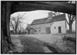
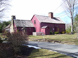
- Richard Briggs FarmRichard Briggs FarmThe Richard Briggs Farm is a historic farmhouse at 830 South Road in East Greenwich, Rhode Island.The farm was built in 1735 and added to the National Register of Historic Places in 2003....
- East Greenwich Historic DistrictEast Greenwich Historic DistrictEast Greenwich Historic District is a historic district roughly bounded by Kenyon Avenue, Division, Peirce, & London Streets, Greenwich Cove and Dark Entry Brook in East Greenwich and Warwick in the U.S. state of Rhode Island....
- Fry's Hamlet Historic DistrictFry's Hamlet Historic DistrictFry's Hamlet Historic District is a historic district at 2068, 2153, 2196, and 2233 South County Trail in East Greenwich, Rhode Island.The district was settled in 1735 and added to the National Register of Historic Places in 1985....
- Kent County CourthouseKent County CourthouseThe Kent County Courthouse is a historic court building at 127 Main Street in East Greenwich, Rhode Island, United States.The courthouse was built in 1803 and added to the National Register of Historic Places in 1970.-References:...
- Massie Wireless StationMassie Wireless StationThe Massie Wireless Station was built in Point Judith, Rhode Island in 1907 and is the oldest surviving working wireless station in the world. It is now part of the New England Wireless and Steam Museum....
- Tillinghast Mill SiteTillinghast Mill SiteThe Tillinghast Mill Site is an historic site in East Greenwich, Rhode Island added to the National Register of Historic Places in 1988.It is part of Frenchtown Park, situated behind the Recreation Department Building. It can be accessed via Frenchtown Road...
- Tillinghast Road Historic DistrictTillinghast Road Historic DistrictTillinghast Road Historic District is a historic site on Tillinghast Rd. in East Greenwich, Rhode Island added to the National Register of Historic Places in 1988.The district contains parts of the New England Wireless and Steam Museum....
- Clement Weaver-Daniel Howland HouseClement Weaver-Daniel Howland HouseThe Clement Weaver-Daniel Howland House, is a historic stone-ender timber frame house built in 1679. It is located at 125 Howland Road in East Greenwich, Rhode Island...
- Col. Micah Whitmarsh HouseCol. Micah Whitmarsh HouseThe Colonel Micah Whitmarsh House is an historic house at 294 Main Street in East Greenwich, Rhode Island.The house was built in 1767 and added to the National Register of Historic Places in 1971....
- Windmill CottageWindmill CottageWindmill Cottage is a historic house and former windmill at 144 Division Street in East Greenwich, Rhode Island. It was the home of George Washington Greene, a former American consul to Rome and historian. It was purchased for Greene by his friend, the poet Henry Wadsworth Longfellow.-History:The...
- Thunder Road