
Dupo, Illinois
Encyclopedia
Dupo is a village in St. Clair County
, Illinois
, United States
. The population was 3,933 at the 2000 census. The village was settled in about 1750 and was incorporated in 1876. Its name is derived from Prairie du Pont .
floodplain
of the Mississippi River
.
According to the United States Census Bureau
, the village has a total area of 4.4 square miles (11.4 km²),
of 2000, there were 3,933 people, 1,557 households, and 1,063 families residing in the village. The population density
was 888.6 people per square mile (342.8/km²). There were 1,668 housing units at an average density of 376.9 per square mile (145.4/km²). The racial makeup of the village was 97.20% White, 1.17% African American, 0.31% Native American, 0.25% Asian, 0.36% from other races
, and 0.71% from two or more races. Hispanic or Latino of any race were 0.69% of the population.
There were 1,557 households out of which 32.6% had children under the age of 18 living with them, 52.9% were married couples
living together, 11.0% had a female householder with no husband present, and 31.7% were non-families. 26.1% of all households were made up of individuals and 10.9% had someone living alone who was 65 years of age or older. The average household size was 2.53 and the average family size was 3.04.
In the village the population was spread out with 25.2% under the age of 18, 10.7% from 18 to 24, 30.5% from 25 to 44, 21.4% from 45 to 64, and 12.1% who were 65 years of age or older. The median age was 35 years. For every 100 females there were 96.0 males. For every 100 females age 18 and over, there were 92.9 males.
The median income for a household in the village was $43,036, and the median income for a family was $47,000. Males had a median income of $35,529 versus $24,135 for females. The per capita income
for the village was $18,505. About 2.9% of families and 4.3% of the population were below the poverty line, including 5.2% of those under age 18 and 3.8% of those age 65 or over.
St. Clair County, Illinois
St. Clair County is a county located in the U.S. state of Illinois. In 1970, the U.S. Census Bureau placed the mean center of U.S. population in St. Clair County. According to the 2010 census, it has a population of 270,056, which is an increase of 5.5% from 256,082 in 2000. Its county seat is...
, Illinois
Illinois
Illinois is the fifth-most populous state of the United States of America, and is often noted for being a microcosm of the entire country. With Chicago in the northeast, small industrial cities and great agricultural productivity in central and northern Illinois, and natural resources like coal,...
, United States
United States
The United States of America is a federal constitutional republic comprising fifty states and a federal district...
. The population was 3,933 at the 2000 census. The village was settled in about 1750 and was incorporated in 1876. Its name is derived from Prairie du Pont .
Geography
Dupo is located at 38°30′57"N 90°12′29"W (38.515702, -90.207992). It is located in the American BottomAmerican Bottom
The American Bottom is the flood plain of the Mississippi River in the Metro-East region of Southern Illinois, extending from Alton, Illinois, to the Kaskaskia River. It is also sometimes called "American Bottoms". The area is about , mostly protected from flooding by a levee and drainage canal...
floodplain
Floodplain
A floodplain, or flood plain, is a flat or nearly flat land adjacent a stream or river that stretches from the banks of its channel to the base of the enclosing valley walls and experiences flooding during periods of high discharge...
of the Mississippi River
Mississippi River
The Mississippi River is the largest river system in North America. Flowing entirely in the United States, this river rises in western Minnesota and meanders slowly southwards for to the Mississippi River Delta at the Gulf of Mexico. With its many tributaries, the Mississippi's watershed drains...
.
According to the United States Census Bureau
United States Census Bureau
The United States Census Bureau is the government agency that is responsible for the United States Census. It also gathers other national demographic and economic data...
, the village has a total area of 4.4 square miles (11.4 km²),
History
From St. Clair County History, (Philadelphia: Brink, McDonough, and Company, 1881):- "The village received its name from the following circumstance: The first settlement was made on the present site, which is on the south bank of the creek, and about one mile (1.6 km) south of the village of CahokiaCahokia, IllinoisCahokia is a village in St. Clair County, Illinois, United States. As of the 2000 census, the village had a population of 16,391. The name is a reference to one of the clans of the historic Illini confederacy, who were encountered by early French explorers to the region.Early European settlers also...
. At this point a rude bridge, constructed of logs, was built across the stream. An open prairiePrairiePrairies are considered part of the temperate grasslands, savannas, and shrublands biome by ecologists, based on similar temperate climates, moderate rainfall, and grasses, herbs, and shrubs, rather than trees, as the dominant vegetation type...
extended from the bridge south to the bluffCliffIn geography and geology, a cliff is a significant vertical, or near vertical, rock exposure. Cliffs are formed as erosion landforms due to the processes of erosion and weathering that produce them. Cliffs are common on coasts, in mountainous areas, escarpments and along rivers. Cliffs are usually...
. Pont is a FrenchFrench languageFrench is a Romance language spoken as a first language in France, the Romandy region in Switzerland, Wallonia and Brussels in Belgium, Monaco, the regions of Quebec and Acadia in Canada, and by various communities elsewhere. Second-language speakers of French are distributed throughout many parts...
word, and means bridge in English. Hence the name, Prairie du Pont, or, Prairie Bridge [actually Bridge Prairie]. It was settled about 1750, by people from Cahokia. The origin of its settlement is undoubtedly due to the inundations to which the bottomAmerican BottomThe American Bottom is the flood plain of the Mississippi River in the Metro-East region of Southern Illinois, extending from Alton, Illinois, to the Kaskaskia River. It is also sometimes called "American Bottoms". The area is about , mostly protected from flooding by a levee and drainage canal...
was subject during high waters. Prairie du Pont is about ten or twelve feet higher than Cahokia, and in the time of the floods, the people of the Latter village were obliged to flee to the bluffs and higher grounds for safety. Tradition, in Prairie du Pont, substantiates the above theory."
- "However some will argue that the name actually came from a mispronunciation of the word Depot when the first train tracks were laid through that area. It's said that a railroad engineer (Lee Goudey) with a speech impediment said they "needed to build a dupo in this area" instead of depot. The name stuck and became an official town called Dupo."
- "According to Reynolds, the village contained fourteen families in 1765. Among the early settlers was Jean François Perry, who was a native of France, and emigrated to this country in 1792. He was a classical scholar, and was a descendant of one of the first families in France."
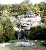
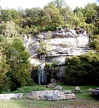
- Falling Springs "is one of the romantic spots in Illinois. It is situated at the bluffCliffIn geography and geology, a cliff is a significant vertical, or near vertical, rock exposure. Cliffs are formed as erosion landforms due to the processes of erosion and weathering that produce them. Cliffs are common on coasts, in mountainous areas, escarpments and along rivers. Cliffs are usually...
, one mile (1.6 km) south-east of Prairie du Pont village. It derives its name from a springSpring (hydrosphere)A spring—also known as a rising or resurgence—is a component of the hydrosphere. Specifically, it is any natural situation where water flows to the surface of the earth from underground...
that gushes out of a perpendicular rock of the bluff, with a fall of sixty or seventy feet. The bluff at this point is a solid wall of limestoneLimestoneLimestone is a sedimentary rock composed largely of the minerals calcite and aragonite, which are different crystal forms of calcium carbonate . Many limestones are composed from skeletal fragments of marine organisms such as coral or foraminifera....
, about one hundred and thirty feet in height. The spring flows from an orifice situated midway between the top of the bluff and the rocky bottom beneath. Many years ago a grist mill was constructed at this point, and the water utilized for a power, but no trace of it remains at this time to be seen. Several years ago a hotel was built near the spring, and the place was made a summer resort by the people of East St. LouisEast St. Louis, IllinoisEast St. Louis is a city located in St. Clair County, Illinois, USA, directly across the Mississippi River from St. Louis, Missouri in the Metro-East region of Southern Illinois. As of the 2010 census, the city had a total population of 27,006, less than one-third of its peak of 82,366 in 1950...
and other towns."
Demographics
As of the censusCensus
A census is the procedure of systematically acquiring and recording information about the members of a given population. It is a regularly occurring and official count of a particular population. The term is used mostly in connection with national population and housing censuses; other common...
of 2000, there were 3,933 people, 1,557 households, and 1,063 families residing in the village. The population density
Population density
Population density is a measurement of population per unit area or unit volume. It is frequently applied to living organisms, and particularly to humans...
was 888.6 people per square mile (342.8/km²). There were 1,668 housing units at an average density of 376.9 per square mile (145.4/km²). The racial makeup of the village was 97.20% White, 1.17% African American, 0.31% Native American, 0.25% Asian, 0.36% from other races
Race (United States Census)
Race and ethnicity in the United States Census, as defined by the Federal Office of Management and Budget and the United States Census Bureau, are self-identification data items in which residents choose the race or races with which they most closely identify, and indicate whether or not they are...
, and 0.71% from two or more races. Hispanic or Latino of any race were 0.69% of the population.
There were 1,557 households out of which 32.6% had children under the age of 18 living with them, 52.9% were married couples
Marriage
Marriage is a social union or legal contract between people that creates kinship. It is an institution in which interpersonal relationships, usually intimate and sexual, are acknowledged in a variety of ways, depending on the culture or subculture in which it is found...
living together, 11.0% had a female householder with no husband present, and 31.7% were non-families. 26.1% of all households were made up of individuals and 10.9% had someone living alone who was 65 years of age or older. The average household size was 2.53 and the average family size was 3.04.
In the village the population was spread out with 25.2% under the age of 18, 10.7% from 18 to 24, 30.5% from 25 to 44, 21.4% from 45 to 64, and 12.1% who were 65 years of age or older. The median age was 35 years. For every 100 females there were 96.0 males. For every 100 females age 18 and over, there were 92.9 males.
The median income for a household in the village was $43,036, and the median income for a family was $47,000. Males had a median income of $35,529 versus $24,135 for females. The per capita income
Per capita income
Per capita income or income per person is a measure of mean income within an economic aggregate, such as a country or city. It is calculated by taking a measure of all sources of income in the aggregate and dividing it by the total population...
for the village was $18,505. About 2.9% of families and 4.3% of the population were below the poverty line, including 5.2% of those under age 18 and 3.8% of those age 65 or over.