

Duisburg Inner Harbour
Encyclopedia
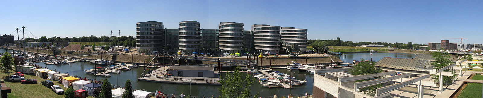
The Innenhafen in Duisburg
, encompassing an area of 89ha., was for over a hundred years, during the high point of the Industrial Revolution
, the central harbor and trading point of the town. Since the mid-60s, the importance of the harbour declined and it lay in a disused condition for 20 years, before plans for renovation were drawn up. This former industrial area been fundamentally transformed, a process which started as a part of the International Building Exhibition Emscher Park (IBA) which ran from 1989 until 1999.
The basis for this model of development in the Ruhr district was delivered in 1994 by the British architect Norman Foster. Since then, the Inner Harbor has transformed itself into a district combining employment, housing, culture and water-based leisure activities. Today, the Inner Harbour is both an industrial monument and a main point on the Route der Industriekultur.
During the Middle Ages, situated on the present-day location of the Rathaus, there was a Frankish regal court positioned directly on the banks of the Rhine. On the same spot were to be found the old Duisburg town church, the Salvatorkirche, the market hall and the city walls.
Sometime around the year 1000 – according to recent research – the Rhine shifted its course westwards. Duisburg found itself no longer lying directly on the Rhine; however, for about another 400 years it did remain connected to the river by a navigable ‘dead’ arm of the Rhine. Subsequently, this previously important trading town declined into a small agricultural settlement. It was only in the 19th century that an initiative to resurrect the connection to the Rhine proved successful. Initially, the Outer Harbor was dug from the Rhine in the west as far as the contemporary Marientor Bridge, to which an eastern extension was later built, the Inner Harbor. Early on, the timber industry established itself on the harbor, mining.interest being a major customer for their products Then, as modern production methods were able to reduce their space requirements, grain mills established themselves in several locations, along with their warehouses for storage. They conferred on the Inner Harbor the nickname "bread basket of the Ruhr district“, supplying the rapidly growing population in the district.
After the decline of the grain mills in the 1960s, the Inner Harbor lost its economic significance and was characterized primarily by warehousing. Nevertheless, the district still continued to block off access to the water from the city itself. The first steps in giving the inner harbour a new face were taken at the end of the 80s with the opening up of city walls and the construction of a new living quarter on Corputiusplatz.
Within the framework of the IBA Emscher Park, which renovated the industrial areas of the Ruhr in an exemplary fashion, a design for the transformation of the entire Inner Harbour was launched. The water was to be re-incorporated into the city, it was to be made freely accessible and produce an enhanced quality of living – and attract investors. Space for employment – especially in the service sector – for living, culture and leisure were to be integrated into the overall plan. In this sense, the industrial and historic “symbols“ of the harbor were to be quite consciously retained.
converted to an arts museum by Herzog & de Meuron
, the Werhahnmühle, which following the departure of the Children's Museum ATLANTIS is being used as a “Legoland
Discovery Center“, the Cultural- and City History Museum, the “Garden of Remembrance“ laid out by Dani Karavan
as well as the Synagoge of the Jewish District of Duisburg-Mülheim/Ruhr-Oberhausen, designed by the architect Zvi Hecker
.
Additionally, on the far side of the Garden a marina
has been built complete with a Buckelbrücke ('Buckle bridge' – for pedestrians). It is intended to extend the marina into the adjacent Holzhafen.
A lively dining-scene has also developed. In addition to more than 15 restaurants und clubs, there are also owner-run bars and franchises.
For the western part of the Inner Harbor, which borders directly onto the Altstadt, Foster has come up with a new master plan
, under contract from the City Council, which foresees a transformation similar to that which has been carried out in the eastern section – and which is itself still ongoing: A further area for new building lies at the extreme Eastern end, near to the Küppersmühle, which itself has plans for extension, following the need for more space due to the fusion of the Grothe und Strцher collections. At the back of the office building on the Northern bank, a park is envisaged. In order to coordinate the ideas of the planners with respect to both the Inner Harbor and the City Center, the area of responsibility of the Innenhafen-Entwicklungsgesellschaft (Inner Harbor Development Society) now also includes the management of the renovation of the entire city center.
As from 2010 the Land Archive of NRW will be based in the Upper Harbor. Up until now it has been based in Düsseldorf (Main Archive) and Brühl (Personenstandsarchiv Brühl). In December 2007 the Austrian architects Ortner und Ortner received the commission for converting a listed storage building from the 30s.
51°26′27"N 6°45′58"E
Duisburg
- History :A legend recorded by Johannes Aventinus holds that Duisburg, was built by the eponymous Tuisto, mythical progenitor of Germans, ca. 2395 BC...
, encompassing an area of 89ha., was for over a hundred years, during the high point of the Industrial Revolution
Industrial Revolution
The Industrial Revolution was a period from the 18th to the 19th century where major changes in agriculture, manufacturing, mining, transportation, and technology had a profound effect on the social, economic and cultural conditions of the times...
, the central harbor and trading point of the town. Since the mid-60s, the importance of the harbour declined and it lay in a disused condition for 20 years, before plans for renovation were drawn up. This former industrial area been fundamentally transformed, a process which started as a part of the International Building Exhibition Emscher Park (IBA) which ran from 1989 until 1999.
The basis for this model of development in the Ruhr district was delivered in 1994 by the British architect Norman Foster. Since then, the Inner Harbor has transformed itself into a district combining employment, housing, culture and water-based leisure activities. Today, the Inner Harbour is both an industrial monument and a main point on the Route der Industriekultur.
History
Where today you observe the Inner Harbor, flowed many centuries ago the Rhine. Up until the 5th century, it formed in this locality the boundary with the Roman Empire.During the Middle Ages, situated on the present-day location of the Rathaus, there was a Frankish regal court positioned directly on the banks of the Rhine. On the same spot were to be found the old Duisburg town church, the Salvatorkirche, the market hall and the city walls.
Sometime around the year 1000 – according to recent research – the Rhine shifted its course westwards. Duisburg found itself no longer lying directly on the Rhine; however, for about another 400 years it did remain connected to the river by a navigable ‘dead’ arm of the Rhine. Subsequently, this previously important trading town declined into a small agricultural settlement. It was only in the 19th century that an initiative to resurrect the connection to the Rhine proved successful. Initially, the Outer Harbor was dug from the Rhine in the west as far as the contemporary Marientor Bridge, to which an eastern extension was later built, the Inner Harbor. Early on, the timber industry established itself on the harbor, mining.interest being a major customer for their products Then, as modern production methods were able to reduce their space requirements, grain mills established themselves in several locations, along with their warehouses for storage. They conferred on the Inner Harbor the nickname "bread basket of the Ruhr district“, supplying the rapidly growing population in the district.
After the decline of the grain mills in the 1960s, the Inner Harbor lost its economic significance and was characterized primarily by warehousing. Nevertheless, the district still continued to block off access to the water from the city itself. The first steps in giving the inner harbour a new face were taken at the end of the 80s with the opening up of city walls and the construction of a new living quarter on Corputiusplatz.
Within the framework of the IBA Emscher Park, which renovated the industrial areas of the Ruhr in an exemplary fashion, a design for the transformation of the entire Inner Harbour was launched. The water was to be re-incorporated into the city, it was to be made freely accessible and produce an enhanced quality of living – and attract investors. Space for employment – especially in the service sector – for living, culture and leisure were to be integrated into the overall plan. In this sense, the industrial and historic “symbols“ of the harbor were to be quite consciously retained.
The Inner Harbor today
Highlights of the newly-renovated quarter of the Inner Harbor are the KüppersmühleMuseum Küppersmühle
Museum Küppersmühle is a Centre for Modern and Contemporary Art based Duisburg's Inner Harbour. It houses the Ströher Collection. It is part of the Duisburg: Town and Harbour section of the Ruhr Industrial Heritage Trail.-Architecture:...
converted to an arts museum by Herzog & de Meuron
Herzog & de Meuron
Herzog & de Meuron Architekten, BSA/SIA/ETH is a Swiss architecture firm, founded and headquartered in Basel, Switzerland in 1978. The careers of founders and senior partners Jacques Herzog , and Pierre de Meuron , closely paralleled one another, with both attending the Swiss Federal Institute of...
, the Werhahnmühle, which following the departure of the Children's Museum ATLANTIS is being used as a “Legoland
Legoland
Legoland is a chain of Lego-themed theme parks. They are not fully owned by Lego Group itself; rather they are owned and operated by the British theme park company Merlin Entertainment.The chain currently consists of:* Legoland Billund...
Discovery Center“, the Cultural- and City History Museum, the “Garden of Remembrance“ laid out by Dani Karavan
Dani Karavan
Dani Karavan is an Israeli sculptor best known for site specific memorials and monuments which merge into the environment, though he has made important installations as well as other significant contributions to art and architecture.- Biography :Dani Karavan's father Abraham was the chief...
as well as the Synagoge of the Jewish District of Duisburg-Mülheim/Ruhr-Oberhausen, designed by the architect Zvi Hecker
Zvi Hecker
Zvi Hecker is a Polish-born Israeli architect. His work is known for its emphasis on geometry and asymmetry.-Biography:Zvi Hecker was born on May 31, 1931 in Krakow, Poland. He grew up in Poland and Samarkand. He began his education in architecture at the Cracow University of Technology. He...
.
Additionally, on the far side of the Garden a marina
Marina
A marina is a dock or basin with moorings and supplies for yachts and small boats.A marina differs from a port in that a marina does not handle large passenger ships or cargo from freighters....
has been built complete with a Buckelbrücke ('Buckle bridge' – for pedestrians). It is intended to extend the marina into the adjacent Holzhafen.
A lively dining-scene has also developed. In addition to more than 15 restaurants und clubs, there are also owner-run bars and franchises.
Progression of Developments
After a previous project had run into problems revolving around the awarding of the contract, 2008 should see an investor beginning the construction of Eurogate, a semi-elliptical multi-functional building with up to 10 floors and a floor area of about 35.000 m2. The design for this building, by Foster, follows the curvature of the Holzhafen. Works for reclamation of land on the bank hit the news when a crane overturned and burnt-out.For the western part of the Inner Harbor, which borders directly onto the Altstadt, Foster has come up with a new master plan
Master plan
A master plan has many meanings, it can refer to:Generally it may be used for serious plans or strategies, see:*Strategy**Strategic planning**Comprehensive planning**Blueprint...
, under contract from the City Council, which foresees a transformation similar to that which has been carried out in the eastern section – and which is itself still ongoing: A further area for new building lies at the extreme Eastern end, near to the Küppersmühle, which itself has plans for extension, following the need for more space due to the fusion of the Grothe und Strцher collections. At the back of the office building on the Northern bank, a park is envisaged. In order to coordinate the ideas of the planners with respect to both the Inner Harbor and the City Center, the area of responsibility of the Innenhafen-Entwicklungsgesellschaft (Inner Harbor Development Society) now also includes the management of the renovation of the entire city center.
As from 2010 the Land Archive of NRW will be based in the Upper Harbor. Up until now it has been based in Düsseldorf (Main Archive) and Brühl (Personenstandsarchiv Brühl). In December 2007 the Austrian architects Ortner und Ortner received the commission for converting a listed storage building from the 30s.
Panorama
External links
- Information Anchor Point "Duisburg Inner Harbour" on the Industrial Heritage Trail in the Ruhr Area (englich)
- Innenhafen Duisburg Portal (german)
- Innenhafen Duisburg (german)
- Fosters Plan for the inner city incl. inner harbor (german/english)
51°26′27"N 6°45′58"E