
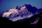
Dome Peak
Encyclopedia
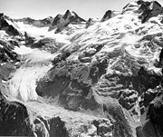
Glacier
A glacier is a large persistent body of ice that forms where the accumulation of snow exceeds its ablation over many years, often centuries. At least 0.1 km² in area and 50 m thick, but often much larger, a glacier slowly deforms and flows due to stresses induced by its weight...
mountain in the Glacier Peak Wilderness
Glacier Peak Wilderness
The Glacier Peak Wilderness, created by the US Forest Service in 1960 by efforts of the , four years before the 1964 wilderness legislation of the Congress, is located within portions of Chelan County, Snohomish County, and Skagit Counties in the North Cascades of Washington...
of Washington's North Cascades
North Cascades
The North Cascades are a section of the Cascade Range of western North America. They span the border between the Canadian province of British Columbia and the U.S. state of Washington and are officially named in Canada as the Cascade Mountains...
. The remote location of Dome Peak, combined with its height, make it a less common destination for Cascade Range
Cascade Range
The Cascade Range is a major mountain range of western North America, extending from southern British Columbia through Washington and Oregon to Northern California. It includes both non-volcanic mountains, such as the North Cascades, and the notable volcanoes known as the High Cascades...
mountaineer
Mountaineer
-Sports:*Mountaineering, the sport, hobby or profession of walking, hiking, trekking and climbing up mountains, also known as alpinism-University athletic teams and mascots:*Appalachian State Mountaineers, the athletic teams of Appalachian State University...
s. Dome Peak is at the southern end of the Ptarmigan Traverse
Ptarmigan Traverse
The Ptarmigan Traverse is a famous alpine hiking route in Washington State's North Cascades. The route, from Cascade Pass to Dome Peak, is generally remote, unmarked, and challenging.-History:...
mountaineering route. It is located at the extreme southeast corner of Skagit County
Skagit County, Washington
Skagit County is a county in the U.S. state of Washington. It is named after the Skagit Indian tribe. As of 2010, the population was 116,901. It is included in the Mount Vernon-Anacortes, Washington, Metropolitan Statistical Area...
. The mountain was given its name by Albert H. Sylvester
Albert Hale Sylvester
Albert Hale Slyvester was a pioneer surveyor, explorer, and forest supervisor in the Cascade Range of the U.S. state of Washington. He was a topographer for the United States Geological Survey in the Snoqualmie Ranger District between 1897 and 1907...
, the first forest supervisor of Wenatchee National Forest
Wenatchee National Forest
Wenatchee National Forest is a U.S. National Forest located in Washington. With an area of 1,735,394 acres , it extends about 137 miles along the eastern slopes of the Cascade Range of Washington, USA from Okanogan National Forest to Gifford Pinchot National Forest...
.
There are two main summits connected by a narrow ridge with the northeastern summit being higher than the southwestern. Chickamin Glacier is north of the peak while Dome Glacier is to the west. A rock face drops off to the southeast. Dana Glacier is on the north side of a ridge that connects Dome Peak and Spire Point.
The higher northeast peak was first climbed by George Freed and Eric Larson on August 1, 1936. The southwest peak was first climbed on July 5, 1936 by Forest Farr, Norval Grigg, and Don Blair.