

District of Columbia census statistical areas
Encyclopedia
United States Census Bureau
The United States Census Bureau is the government agency that is responsible for the United States Census. It also gathers other national demographic and economic data...
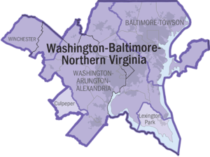
has defined one Combined Statistical Area
Combined Statistical Area
The United States Office of Management and Budget defines micropolitan and metropolitan statistical areas. Metropolitan and micropolitan statistical areas consist of one or more counties...
(CSA) and one Metropolitan Statistical Area (MSA) in the District of Columbia. The following table describes these areas with the following information:
- The name of the Combined Statistical Area (CSA), if any.
- The population of the CSA as of 2006-07-01, as estimated by the United States Census Bureau.
- The name of the Core Based Statistical AreaCore based statistical areaA Core Based Statistical Area is a U.S. geographic area defined by the Office of Management and Budget based around an urban center of at least 10,000 people and adjacent areas that are socioeconomically tied to the urban center by commuting. Areas defined on the basis of these standards applied...
(CBSA). - The population of the CBSA as of 2006-07-01, as estimated by the United States Census Bureau.
- The name of the federal district, countyCounty (United States)In the United States, a county is a geographic subdivision of a state , usually assigned some governmental authority. The term "county" is used in 48 of the 50 states; Louisiana is divided into parishes and Alaska into boroughs. Parishes and boroughs are called "county-equivalents" by the U.S...
, or independent cityIndependent cityAn independent city is a city that does not form part of another general-purpose local government entity. These type of cities should not be confused with city-states , which are fully sovereign cities that are not part of any other sovereign state.-Historical precursors:In the Holy Roman Empire,...
. - The population of the federal district, county, or independent city as of 2006-07-01, as estimated by the United States Census Bureau.
| Combined Statistical Area | 2006 Pop | Core Based Statistical Area | 2006 Pop | County | 2006 Pop |
|---|---|---|---|---|---|
| Washington-Baltimore-Northern Virginia, DC-MD-VA-WV CSA | 8,211,213 581,530 |
Washington-Arlington-Alexandria, DC-VA-MD-WV MSA | 5,290,400 581,530 |
Fairfax County, Virginia Fairfax County, Virginia Fairfax County is a county in Virginia, in the United States. Per the 2010 Census, the population of the county is 1,081,726, making it the most populous jurisdiction in the Commonwealth of Virginia, with 13.5% of Virginia's population... |
1,010,443 |
| Montgomery County, Maryland Montgomery County, Maryland Montgomery County is a county in the U.S. state of Maryland, situated just to the north of Washington, D.C., and southwest of the city of Baltimore. It is one of the most affluent counties in the United States, and has the highest percentage of residents over 25 years of age who hold post-graduate... |
932,131 | ||||
| Prince George's County, Maryland Prince George's County, Maryland Prince George's County is a county located in the U.S. state of Maryland, immediately north, east, and south of Washington, DC. As of 2010, it has a population of 863,420 and is the wealthiest African-American majority county in the nation.... |
841,315 | ||||
| District of Columbia | 581,530 | ||||
| Prince William County, Virginia Prince William County, Virginia -National protected areas:* Featherstone National Wildlife Refuge* Manassas National Battlefield Park* Occoquan Bay National Wildlife Refuge* Prince William Forest Park-Government and politics:... |
357,503 | ||||
| Loudoun County, Virginia Loudoun County, Virginia Loudoun County is a county located in the Commonwealth of Virginia, and is part of the Washington Metropolitan Area. As of the 2010 U.S. Census, the county is estimated to be home to 312,311 people, an 84 percent increase over the 2000 figure of 169,599. That increase makes the county the fourth... |
268,817 | ||||
| Frederick County, Maryland Frederick County, Maryland Frederick County is a county located in the western part of the U.S. state of Maryland, bordering the southern border of Pennsylvania and the northeastern border of Virginia. As of the 2010 Census, the population was 233,385.... |
222,938 | ||||
| Arlington County, Virginia Arlington County, Virginia Arlington County is a county in the Commonwealth of Virginia. The land that became Arlington was originally donated by Virginia to the United States government to form part of the new federal capital district. On February 27, 1801, the United States Congress organized the area as a subdivision of... |
199,776 | ||||
| Charles County, Maryland Charles County, Maryland Charles County is a county in the south central portion of the U.S. state of Maryland.As of 2010, the population was 146,551. Its county seat is La Plata. This county was named for Charles Calvert , third Baron Baltimore.... |
140,416 | ||||
| City of Alexandria, Virginia | 136,974 | ||||
| Stafford County, Virginia Stafford County, Virginia Stafford County is a county located in the Commonwealth of Virginia, a U.S. state, and just across the Rappahannock River from the City of Fredericksburg. As of the 2000 census, the population was 92,446, increasing to 128,961 in 2010.. Its county seat is Stafford. In 2006, and again in 2009,... |
120,170 | ||||
| Spotsylvania County, Virginia Spotsylvania County, Virginia As of the census of 2000, there were 90,395 people, 31,308 households, and 24,639 families residing in the county. The population density was 226 people per square mile . There were 33,329 housing units at an average density of 83 per square mile... |
119,529 | ||||
| Calvert County, Maryland Calvert County, Maryland Calvert County is a county located in the U.S. state of Maryland. It occupies the Calvert Peninsula which is bordered on the east by the Chesapeake Bay and on the west by the Patuxent River. Calvert County is part of the Southern Maryland region. Calvert County's residents are among the highest... |
88,804 | ||||
| Fauquier County, Virginia Fauquier County, Virginia As of the census of 2000, there were 55,139 people, 19,842 households, and 15,139 families residing in the county. The population density was 85 people per square mile . There were 21,046 housing units at an average density of 32 per square mile... |
66,170 | ||||
| Jefferson County, West Virginia Jefferson County, West Virginia Jefferson County is a county located in the U.S. state of West Virginia. As of 2010, the population was 53,498. Its county seat is Charles Town... |
50,443 | ||||
| City of Manassas, Virginia | 36,638 | ||||
| Warren County, Virginia Warren County, Virginia As of the census of 2000, there were 31,584 people, 12,087 households, and 8,521 families residing in the county. The population density was 148 people per square mile . There were 13,299 housing units at an average density of 62 per square mile... |
36,102 | ||||
| City of Fairfax, Virginia | 22,422 | ||||
| City of Fredericksburg, Virginia | 21,273 | ||||
| Clarke County, Virginia Clarke County, Virginia Clarke County is a county in the Commonwealth of Virginia. As of 2010, the population was 14,034. Its county seat is Berryville.-History:Clarke County was established in 1836 by Thomas Fairfax, 6th Lord Fairfax of Cameron who built a home, Greenway Court, on part of his 5 million acre property,... |
14,565 | ||||
| City of Manassas Park, Virginia | 11,642 | ||||
| City of Falls Church, Virginia | 10,799 | ||||
| Baltimore-Towson, MD MSA | 2,658,405 | Baltimore County, Maryland Baltimore County, Maryland Baltimore County is a county located in the northern part of the US state of Maryland. In 2010, its population was 805,029. It is part of the Baltimore-Washington Metropolitan Area. Its county seat is Towson. The name of the county was derived from the barony of the Proprietor of the Maryland... |
787,384 | ||
| Baltimore City, Maryland | 631,366 | ||||
| Anne Arundel County, Maryland Anne Arundel County, Maryland Anne Arundel County is a county located in the U.S. state of Maryland. It is named for Anne Arundell , a member of the ancient family of Arundells in Cornwall, England and the wife of Cæcilius Calvert, 2nd Baron Baltimore. Its county seat is Annapolis, which is also the capital of the state... |
509,300 | ||||
| Howard County, Maryland Howard County, Maryland -2010:Whereas according to the 2010 U.S. Census Bureau:*62.2% White*17.5% Black*0.3% Native American*14.4% Asian*0.0% Native Hawaiian or Pacific Islander*3.6% Two or more races*2.0% Other races*5.8% Hispanic or Latino -2000:... |
272,452 | ||||
| Harford County, Maryland Harford County, Maryland Harford County is a county in the U.S. state of Maryland. In 2010, its population was 244,826. Its county seat is Bel Air. Harford County forms part of the Baltimore-Washington Metropolitan Area.-History:... |
241,402 | ||||
| Carroll County, Maryland Carroll County, Maryland Carroll County is a county located in the U.S. state of Maryland. In 2010, its population was 167,134. It was named for Charles Carroll of Carrollton , signer of the American Declaration of Independence. Its county seat is Westminster.... |
170,260 | ||||
| Queen Anne's County, Maryland Queen Anne's County, Maryland Queen Anne's County is a county located on the Eastern Shore of the U.S. state of Maryland.As of 2010, the population was 47,798. Its county seat and most populous municipality is Centreville. The census-designated place of Stevensville is the county's most populous place... |
46,241 | ||||
| Winchester, VA-WV MSA Winchester, VA-WV MSA Winchester, VA-WV MSA is a U.S. Metropolitan Statistical Area as defined by the United States Office of Management and Budget as of June, 2003. Its population as of 2008 U.S. Census Bureau estimates is 122,369.... |
118,932 | Frederick County, Virginia Frederick County, Virginia Frederick County is a county located in the Commonwealth of Virginia. It is included in the Winchester, Virginia-West Virginia Metropolitan Statistical Area. It was formed in 1743 by the splitting of Orange County. For ten years it was the home of George Washington. As of 2010, the population was... |
71,187 | ||
| City of Winchester, Virginia | 25,265 | ||||
| Hampshire County, West Virginia Hampshire County, West Virginia Hampshire County is a county located in the U.S. state of West Virginia. As of 2010, the population was 23,964. Its county seat is Romney, West Virginia's oldest town . Hampshire County was created by the Virginia General Assembly on December 13, 1753, from parts of Frederick and Augusta counties ... |
22,480 | ||||
| Lexington Park, MD μSA | 98,854 | St. Mary's County, Maryland | 98,854 | ||
| Culpeper, VA μSA | 44,622 | Culpeper County, Virginia Culpeper County, Virginia As of the census of 2000, there were 34,262 people, 12,141 households, and 9,045 families residing in the county. The population density was 90 people per square mile . There were 12,871 housing units at an average density of 34 per square mile... |
44,622 | ||
See also
- District of Columbia
- Demographics of the District of Columbia
- Geography of the District of Columbia
- United StatesUnited StatesThe United States of America is a federal constitutional republic comprising fifty states and a federal district...
- United States Census BureauUnited States Census BureauThe United States Census Bureau is the government agency that is responsible for the United States Census. It also gathers other national demographic and economic data...
- Table of United States Combined Statistical AreasTable of United States Combined Statistical Areasthumb|An enlargeable map of the 125 [[Combined Statistical Area]]s of the [[United States]]The United States Office of Management and Budget has defined 125 Combined Statistical Areas for the United States of America...
(CSA) - Table of United States Core Based Statistical Areas (CBSA)
- Table of United States Metropolitan Statistical AreasTable of United States Metropolitan Statistical Areasthumb|An enlargeable map of the 942 [[Core Based Statistical Area]]s of the [[United States]]. The 367 [[Metropolitan Statistical Area]]s are shown in red....
(MSA) - Table of United States Micropolitan Statistical AreasTable of United States Micropolitan Statistical Areasthumb|An enlargeable map of the 942 [[Core Based Statistical Area]]s of the [[United States]]. The 576 [[Micropolitan Statistical Area]]s are shown in blue....
(μSA) - Table of United States primary census statistical areas (PCSA)
- Table of United States Combined Statistical Areas
- United States Census Bureau