

Dingley Village, Victoria
Encyclopedia
Dingley Village is a suburb in Melbourne
, Victoria
, Australia
, 22 km south-east from Melbourne's central business district
. Its Local Government Area is the City of Kingston
. At the 2006 Census, Dingley Village had a population of 10,072.
in his native Northamptonshire
, England
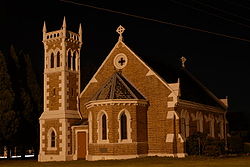
. A farming community developed, relatively remote from either the bayside or Gippsland railway lines, moving into market gardens and poultry to supply metropolitan markets. There was no identifiable centre to the area apart from Christ Church (1873) at the corner of Centre and Old Dandenong Roads, with its attractive architecture and bell tower. The Post Office opened on 21 July 1913.
A family of five brothers - the Gartsides - solved the problem of vegetable gluts by opening a cannery in about 1920. The cannery employed up to fifty local people. They donated land for the primary school which opened in 1925. In 1936 the Kingswood Golf Club, Dandenong
, opened its new course at Dingley. A progress association was formed in 1947, and a recreation reserve acquired in 1954.
Urbanisation in Dingley began in the early 1960s. A small shopping centre, school, kindergarten, reserve and, later, Sunday Markets on the reserve created a village atmosphere which resulted in the official change of name.
Two more primary schools, one Catholic, opened later, along with the Spring Park Public Golf course and nearby tennis-courts complex. Near the Moorabbin Airport
is an industrial zone set in a garden landscape, separated from the Dingley Village residential area by a reservation for the Mornington Peninsula Freeway
.
The rock band Jet
originated from the suburb.
cnr Old Dandenong Road & Heatherton Roads.
Historic building, the church had been a part of the community for 148 years. Traditional style of worship.
on Dingley Village was collected by the Australian Bureau of Statistics
during the 2001 census.
Melbourne
Melbourne is the capital and most populous city in the state of Victoria, and the second most populous city in Australia. The Melbourne City Centre is the hub of the greater metropolitan area and the Census statistical division—of which "Melbourne" is the common name. As of June 2009, the greater...
, Victoria
Victoria (Australia)
Victoria is the second most populous state in Australia. Geographically the smallest mainland state, Victoria is bordered by New South Wales, South Australia, and Tasmania on Boundary Islet to the north, west and south respectively....
, Australia
Australia
Australia , officially the Commonwealth of Australia, is a country in the Southern Hemisphere comprising the mainland of the Australian continent, the island of Tasmania, and numerous smaller islands in the Indian and Pacific Oceans. It is the world's sixth-largest country by total area...
, 22 km south-east from Melbourne's central business district
Melbourne city centre
Melbourne City Centre is an area of Melbourne in Victoria, Australia. It is not to be confused with the larger local government area of the City of Melbourne...
. Its Local Government Area is the City of Kingston
City of Kingston
The City of Kingston is a Local Government Area in Victoria, Australia. It is located in the south-eastern suburbs of Melbourne, its northern boundary lying approximately 15 km from the Melbourne city centre along the north-eastern shorelines of Port Phillip...
. At the 2006 Census, Dingley Village had a population of 10,072.
History
In 1856 Thomas Attenborough bought land in the area and named his house Dingley Grange, after Dingley Hall which had existed near the town of MelbourneMelbourne
Melbourne is the capital and most populous city in the state of Victoria, and the second most populous city in Australia. The Melbourne City Centre is the hub of the greater metropolitan area and the Census statistical division—of which "Melbourne" is the common name. As of June 2009, the greater...
in his native Northamptonshire
Northamptonshire
Northamptonshire is a landlocked county in the English East Midlands, with a population of 629,676 as at the 2001 census. It has boundaries with the ceremonial counties of Warwickshire to the west, Leicestershire and Rutland to the north, Cambridgeshire to the east, Bedfordshire to the south-east,...
, England
England
England is a country that is part of the United Kingdom. It shares land borders with Scotland to the north and Wales to the west; the Irish Sea is to the north west, the Celtic Sea to the south west, with the North Sea to the east and the English Channel to the south separating it from continental...
. A farming community developed, relatively remote from either the bayside or Gippsland railway lines, moving into market gardens and poultry to supply metropolitan markets. There was no identifiable centre to the area apart from Christ Church (1873) at the corner of Centre and Old Dandenong Roads, with its attractive architecture and bell tower. The Post Office opened on 21 July 1913.
A family of five brothers - the Gartsides - solved the problem of vegetable gluts by opening a cannery in about 1920. The cannery employed up to fifty local people. They donated land for the primary school which opened in 1925. In 1936 the Kingswood Golf Club, Dandenong
Dandenong, Victoria
Dandenong is a suburb and major urban centre in metropolitan Melbourne, Victoria, Australia, 30 km south-east from Melbourne's central business district. Situated on Dandenong Creek and mostly flat land at the foothills of Mount Dandenong, it is the main administrative centre for the City of...
, opened its new course at Dingley. A progress association was formed in 1947, and a recreation reserve acquired in 1954.
Urbanisation in Dingley began in the early 1960s. A small shopping centre, school, kindergarten, reserve and, later, Sunday Markets on the reserve created a village atmosphere which resulted in the official change of name.
Two more primary schools, one Catholic, opened later, along with the Spring Park Public Golf course and nearby tennis-courts complex. Near the Moorabbin Airport
Moorabbin Airport
Moorabbin Airport is a general aviation airport for light aircraft located in Mentone, Victoria, Australia. The airport grounds are treated as their own suburb, designated the postcode 3194. The airport opened in December 1949. Originally the intent was to name the airport "Mentone" but this was...
is an industrial zone set in a garden landscape, separated from the Dingley Village residential area by a reservation for the Mornington Peninsula Freeway
Mornington Peninsula Freeway
Mornington Peninsula Freeway is an incomplete freeway in Melbourne, Victoria, Australia, that provides a link from outer suburban Melbourne to the Mornington Peninsula.- History :...
.
The rock band Jet
Jet (band)
Jet are an Australian rock band formed in 2001 while attending St Bede's College Mentone in Melbourne, . The band consists of lead guitarist Cameron Muncey, bassist Mark Wilson, and brothers Nic and Chris Cester on vocals/rhythm guitar and drums respectively...
originated from the suburb.
Education
- Dingley Primary School http://www.dingleyps.vic.edu.au/ (1925), located on the corner of Centre Dandenong and Marcus roads.
- Kingswood Primary School http://www.kingswood.vic.edu.au/ (1976).
- St Mark's Primary School http://www.smkdngly.melb.catholic.edu.au/ is a CatholicRoman Catholic Church in AustraliaThe Catholic Church in Australia is part of the worldwide Catholic Church under the spiritual and administrative leadership of the Pope.Australia is a majority Christian but pluralistic society with no established religion. There are approximately 5.1 million Australian Catholics . Catholicism...
primary school within the Archdiocese of MelbourneArchdiocese of MelbourneThe Roman Catholic Archdiocese of Melbourne is a Latin rite metropolitan archdiocese, located in Melbourne, Victoria, Australia.Erected initially in 1847 as the Diocese of Melbourne, a suffragan diocese of Archdiocese of Sydney, the diocese was elevated in 1874 as an archdiocese of the...
.
Primary Schools
Sporting facilities and clubs
- Dingley Baseball & Softball Club
- Dingley (Dingoes) Football Club competing in the Southern Football LeagueSouthern Football League (Victoria)The Southern Football League is an Australian rules football league, based in the south and south eastern suburbs of Melbourne, Victoria, for both seniors and juniors....
. - Dingley Health Link
- Dingley Netball Club
- Dingley Tennis Club
- Dingley Cricket Club
- Equest Park Equestrian Centre
- Kingswood Golf Club
- Southern Golf Club
- Maroons Netball Club
- Souter and Corrigan Oval
- Spring Park Public Golf Course and Dingley Village Adventure Golf
Churches
- Heatherton-Dingley Uniting Church ("The Little White Church on the Corner")
cnr Old Dandenong Road & Heatherton Roads.
Historic building, the church had been a part of the community for 148 years. Traditional style of worship.
- Christ Church Dingley
- Destiny Church Melbourne
- The Salvation Army - Kingston Gardens
- Village Church
- St. Mark's Catholic Church
Community associations
- Lions Club - Dingley Village
- Rotary Club of Dingley Village
Statistical data
Statistical dataStatistics
Statistics is the study of the collection, organization, analysis, and interpretation of data. It deals with all aspects of this, including the planning of data collection in terms of the design of surveys and experiments....
on Dingley Village was collected by the Australian Bureau of Statistics
Australian Bureau of Statistics
The Australian Bureau of Statistics is Australia's national statistical agency. It was created as the Commonwealth Bureau of Census and Statistics on 8 December 1905, when the Census and Statistics Act 1905 was given Royal assent. It had its beginnings in section 51 of the Constitution of Australia...
during the 2001 census.
See also
- City of SpringvaleCity of SpringvaleThe City of Springvale was a Local Government Area located about southeast of Melbourne, the state capital of Victoria, Australia. The city covered an area of , and existed from 1857 until 1994.-History:...
- the former local government area of which Dingley Village was a part.