

Dingley Freeway
Encyclopedia
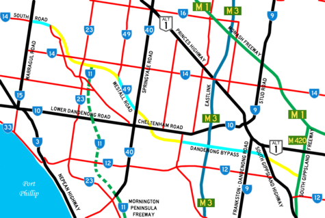
The Dingley Arterial is a partially completed arterial standard road which runs east to west through the southern suburbs of Melbourne
, Australia
.
Although the road was designed to be a freeway for the full length of the planned 19 kilometre route, it has been instead constructed as bypasses for the Melbourne
suburbs of Mordialloc
, Springvale
, and Dandenong
over the years.
, the route travels east, crossing Old Dandenong Road, Clarinda Road, Kingston Road and Boundary Road before intersecting with the proposed northern extension of the Mornington Peninsula Freeway
. It then interchanges with Westall Road
as the route starts to travel in a south easterly direction. The route then crosses Springvale Road, Cheltenham Road, Chapel Road, Stanley Road, Perry Road and Chandler Road before approaching a diamond interchange
with the EastLink
tollway. The route then continues east crossing Hammond Road, Dandenong - Frankston Road
and the South Gippsland Highway
before finishing with a fully grade separated T interchange with the South Gippsland Freeway
in Dandenong South
.
The freeway was originally designated in the 1969 Melbourne Transportation Plan
as part of the F2 Freeway corridor. The original plan shows the freeway extending down South Road over Nepean Highway heading north through Brighton and Elwood, following the Barkly Street-Punt Road-Hoddle Street corridor up through Merri Creek joining the Craigieburn Bypass to the Hume Highway
.
to Old Dandenong Road in Heatherton
. This was designed to remove traffic from White Street, Mordialloc
as it was experiencing heavy-local traffic congestion, as a result of the most direct route linking the Mornington Peninsula Freeway
with the Nepean Highway
, along with Boundary and Wells Road.
The one kilometre extension commenced construction in September 2006 and was completed by the end of 2007, at a cost of $9.3 million dollars for the South Road extension alone, but cost $24.5 million dollars when combined with the associated projects.
The works involved constructing a two lane road to bypass a stretch of Old Dandenong Road which travelled through a residential area to Warrigal Road. A bicycle path was also constructed along the length of the extension. The extension also involved improvements to Old Dandenong Road and surrounding intersections as well as permanently blocking access to Old Dandenong Road north of the extension. The extension has a speed limit of 70 km/h.
Despite the road having successfully removed traffic from Old Dandenong Road (between Warrigal Road and the current South Road connection) it has also created a major bottleneck at the intersection of Kingston and Old Dandenong Road, particularly during peak hour. This intersection will be receiving a major traffic signal upgrade in the coming months.
. It commenced construction in 1994 and was finished in 1995. The extension is also known as the Springvale Bypass.
The works involved creating a 2.8 km divided four lane semi-freeway standard road to bypass the busy and congested centre of Springvale
. The extension involves constructing part of the Dingley Freeway to the future site of an interchange with Westall Road before travelling along a temporary alignment to join up with the extended Westall Road south of Heatherton Road. A speed limit of 100 km/h applies between Heatherton Road and Rowan Road, while a 80 km/h limit applies on the approaches to Heatherton and Springvale Roads. A bicycle path was completed along the entire length of the road.
Associated works included a northern extension of Westall Road from Rayhur Street, Springvale to Princes Highway in Clayton
. Westall Road from Heatherton Road to Centre Road consisted of a two lane undivided road while the road from Centre Road to the Princes Highway was constructed as a six lane divided road. In order to enable Westall Road to truly serve as a high capacity alternative route to Springvale Road, the level crossing with the Cranbourne / Pakenham railway line was grade separated
in conjunction with duplication works to upgrade Westall Road to a six lane divided road between Heatherton Road and Centre Road. These works were completed by April 2001.
to the South Gippsland Highway
in Dandenong South
. The bypass commenced construction in late 2005 and opened on 9 December 2007.
The 4.8 km bypass was constructed as part of the EastLink
project, with the $65 million dollar works involving the creation of a four lane divided road with traffic light controlled access at roads which run north-south along the constructed route. The works also involved the construction of an overpass at the Cranbourne railway line as well as a diamond interchange
with EastLink. The entire bypass has a 80 km/h speed limit.
. The project was previously estimated to cost $80 million, with construction to commence in 2011, with all works completed in 2013.
On 26 October 2010, the Labor government announced plans for funding the section between Warrigal Road and Westall Road as a 4 lane arterial road.
Melbourne
Melbourne is the capital and most populous city in the state of Victoria, and the second most populous city in Australia. The Melbourne City Centre is the hub of the greater metropolitan area and the Census statistical division—of which "Melbourne" is the common name. As of June 2009, the greater...
, Australia
Australia
Australia , officially the Commonwealth of Australia, is a country in the Southern Hemisphere comprising the mainland of the Australian continent, the island of Tasmania, and numerous smaller islands in the Indian and Pacific Oceans. It is the world's sixth-largest country by total area...
.
Although the road was designed to be a freeway for the full length of the planned 19 kilometre route, it has been instead constructed as bypasses for the Melbourne
Melbourne
Melbourne is the capital and most populous city in the state of Victoria, and the second most populous city in Australia. The Melbourne City Centre is the hub of the greater metropolitan area and the Census statistical division—of which "Melbourne" is the common name. As of June 2009, the greater...
suburbs of Mordialloc
Mordialloc, Victoria
Mordialloc is a suburb in Melbourne, Victoria, Australia, 24 km south-east from Melbourne's central business district. Its Local Government Area is the City of Kingston...
, Springvale
Springvale, Victoria
Springvale is a suburb in Melbourne, Victoria, Australia, approximately 20 km south-east from Melbourne's central business district. Its Local Government Area is the City of Greater Dandenong...
, and Dandenong
Dandenong, Victoria
Dandenong is a suburb and major urban centre in metropolitan Melbourne, Victoria, Australia, 30 km south-east from Melbourne's central business district. Situated on Dandenong Creek and mostly flat land at the foothills of Mount Dandenong, it is the main administrative centre for the City of...
over the years.
Intended Course
Starting at the intersection of Warrigal Road and South Road in MoorabbinMoorabbin, Victoria
Moorabbin is a suburb in Melbourne, Victoria, Australia, 15 km south-east from Melbourne's central business district. Its Local Government Area is the City of Kingston. At the 2006 Census, Moorabbin had a population of 5,170....
, the route travels east, crossing Old Dandenong Road, Clarinda Road, Kingston Road and Boundary Road before intersecting with the proposed northern extension of the Mornington Peninsula Freeway
Mornington Peninsula Freeway
Mornington Peninsula Freeway is an incomplete freeway in Melbourne, Victoria, Australia, that provides a link from outer suburban Melbourne to the Mornington Peninsula.- History :...
. It then interchanges with Westall Road
Westall Road
Westall Road is a major north to south thoroughfare west of Springvale, Victoria, Australia.Starting at the intersection with Princes Highway in Clayton, the road travels in a southerly direction, intersecting with Centre Road, an overpass of the Cranbourne and Pakenham railway lines and an...
as the route starts to travel in a south easterly direction. The route then crosses Springvale Road, Cheltenham Road, Chapel Road, Stanley Road, Perry Road and Chandler Road before approaching a diamond interchange
Diamond interchange
A diamond interchange is a common type of road junction, used where a freeway crosses a minor road. The freeway itself is grade-separated from the minor road, one crossing the other over a bridge...
with the EastLink
EastLink, Melbourne
EastLink is a A$2.5 billion tolled freeway linking a large area through the eastern and south-eastern suburbs of Melbourne, Australia. It is a part of Melbourne's Metropolitan Ring Road project....
tollway. The route then continues east crossing Hammond Road, Dandenong - Frankston Road
Dandenong Valley Highway
The Dandenong Valley Highway stretches almost 30 kilometres from Wantirna South in Melbourne's eastern suburbs to Frankston in the south. For its entire length, its main name is not actually Dandenong Valley Highway, and very few locals use it...
and the South Gippsland Highway
South Gippsland Highway
The South Gippsland Highway is a partially divided highway in Victoria, Australia which connects the city of Melbourne with the South Gippsland region of Victoria, ending in the town of Sale...
before finishing with a fully grade separated T interchange with the South Gippsland Freeway
South Gippsland Freeway
South Gippsland Freeway is a short freeway linking Dandenong in Melbourne's south-east to other south-eastern destinations, including the Mornington Peninsula and the Gippsland region...
in Dandenong South
Dandenong South, Victoria
Dandenong South is a suburb in Melbourne, Victoria, Australia, 31 km south-east from Melbourne's central business district. Its Local Government Area is the City of Greater Dandenong. At the 2006 Census, Dandenong South had a population of 4867....
.
The freeway was originally designated in the 1969 Melbourne Transportation Plan
1969 Melbourne Transportation Plan
The 1969 Melbourne Transportation Plan was a road and rail transport plan for Melbourne, the state capital of Victoria, Australia instituted by Henry Bolte's state government...
as part of the F2 Freeway corridor. The original plan shows the freeway extending down South Road over Nepean Highway heading north through Brighton and Elwood, following the Barkly Street-Punt Road-Hoddle Street corridor up through Merri Creek joining the Craigieburn Bypass to the Hume Highway
Hume Highway
The Hume Highway/Hume Freeway is one of Australia's major inter-city highways, running for 880 km between Sydney and Melbourne. It is part of the Auslink National Network and is a vital link for road freight to transport goods to and from the two cities as well as serving Albury-Wodonga and...
.
South Road Extension
The South Road Extension runs along the Dingley Freeway route from Warrigal Road in MoorabbinMoorabbin, Victoria
Moorabbin is a suburb in Melbourne, Victoria, Australia, 15 km south-east from Melbourne's central business district. Its Local Government Area is the City of Kingston. At the 2006 Census, Moorabbin had a population of 5,170....
to Old Dandenong Road in Heatherton
Heatherton, Victoria
Heatherton is a suburb in Melbourne, Victoria, Australia, 20 km south-east from Melbourne's central business district. Its Local Government Area is the City of Kingston. At the 2006 Census, Heatherton had a population of 2,253....
. This was designed to remove traffic from White Street, Mordialloc
Mordialloc, Victoria
Mordialloc is a suburb in Melbourne, Victoria, Australia, 24 km south-east from Melbourne's central business district. Its Local Government Area is the City of Kingston...
as it was experiencing heavy-local traffic congestion, as a result of the most direct route linking the Mornington Peninsula Freeway
Mornington Peninsula Freeway
Mornington Peninsula Freeway is an incomplete freeway in Melbourne, Victoria, Australia, that provides a link from outer suburban Melbourne to the Mornington Peninsula.- History :...
with the Nepean Highway
Nepean Highway
Nepean Highway runs south from the centre of Melbourne in Victoria, Australia to Portsea, along the eastern shore of Port Phillip. It is the primary road route to central Melbourne from Melbourne's southern suburbs.- History :...
, along with Boundary and Wells Road.
The one kilometre extension commenced construction in September 2006 and was completed by the end of 2007, at a cost of $9.3 million dollars for the South Road extension alone, but cost $24.5 million dollars when combined with the associated projects.
The works involved constructing a two lane road to bypass a stretch of Old Dandenong Road which travelled through a residential area to Warrigal Road. A bicycle path was also constructed along the length of the extension. The extension also involved improvements to Old Dandenong Road and surrounding intersections as well as permanently blocking access to Old Dandenong Road north of the extension. The extension has a speed limit of 70 km/h.
Despite the road having successfully removed traffic from Old Dandenong Road (between Warrigal Road and the current South Road connection) it has also created a major bottleneck at the intersection of Kingston and Old Dandenong Road, particularly during peak hour. This intersection will be receiving a major traffic signal upgrade in the coming months.
| South Road Extension | |||
| Westbound | Distance to Melbourne (km) |
Distance to Frankston (km) |
Eastbound |
.svg.png)  Traffic Lights (clockwise from extension) Traffic Lights (clockwise from extension) Warrigal Road Warrigal Road Warrigal Road is a major inner urban road in southeastern Melbourne, Australia. On weekdays, it is usually congested as it runs through many major suburbs along its route, traversing Melbourne's inner eastern and south-eastern suburbs. This includes suburbs such as Chadstone, Oakleigh, and...   to Mentone to MentoneMentone, Victoria Mentone is a suburb in Melbourne, Victoria, Australia, 21 km south-east from Melbourne's central business district. Its Local Government Area is the City of Kingston... (6 km) and Mordialloc Mordialloc, Victoria Mordialloc is a suburb in Melbourne, Victoria, Australia, 24 km south-east from Melbourne's central business district. Its Local Government Area is the City of Kingston... (10 km) South Road to MoorabbinMoorabbin, Victoria Moorabbin is a suburb in Melbourne, Victoria, Australia, 15 km south-east from Melbourne's central business district. Its Local Government Area is the City of Kingston. At the 2006 Census, Moorabbin had a population of 5,170.... (4 km) and Melbourne Melbourne Melbourne is the capital and most populous city in the state of Victoria, and the second most populous city in Australia. The Melbourne City Centre is the hub of the greater metropolitan area and the Census statistical division—of which "Melbourne" is the common name. As of June 2009, the greater... (21 km)  Warrigal Road Warrigal Road Warrigal Road is a major inner urban road in southeastern Melbourne, Australia. On weekdays, it is usually congested as it runs through many major suburbs along its route, traversing Melbourne's inner eastern and south-eastern suburbs. This includes suburbs such as Chadstone, Oakleigh, and... to OakleighOakleigh, Victoria Oakleigh is a suburb of Melbourne, Victoria, Australia and is located 14 km south-east from Melbourne's central business district. Its Local Government Area is the City of Monash. At the 2006 Census, Oakleigh had a population of 6,876.... (6 km) and Burwood Burwood, Victoria Burwood is a suburb in Melbourne, Victoria, Australia, 17 km east from Melbourne's central business district. Its Local Government Area is largely the City of Whitehorse but includes the City of Monash in its south west corner. At the 2006 Census, Burwood had a population of 11,886.-History:The... (12 km) |
|||
| End South Road Extension | 20 | 29 | Start South Road Extension |
| Start South Road Extension from Old Dandenong Road |
21 | 28 | End South Road Extension continues as Old Dandenong Road to Dandenong Dandenong, Victoria Dandenong is a suburb and major urban centre in metropolitan Melbourne, Victoria, Australia, 30 km south-east from Melbourne's central business district. Situated on Dandenong Creek and mostly flat land at the foothills of Mount Dandenong, it is the main administrative centre for the City of... / Frankston Frankston, Victoria Frankston is a suburb within the Greater Melbourne metropolitan area in Victoria, Australia. It is located 40 km southeast of the state capital Melbourne at the southernmost edge of Greater Melbourne, near the beginnings of the Mornington Peninsula... |
Westall Road Extension
The Westall Road Extension runs along the Dingley Freeway route from Westall Road to Springvale Road in Springvale SouthSpringvale South, Victoria
Springvale South is a suburb in Melbourne, Victoria, Australia, 24 km south-east from Melbourne's central business district. Its Local Government Area is the City of Greater Dandenong...
. It commenced construction in 1994 and was finished in 1995. The extension is also known as the Springvale Bypass.
The works involved creating a 2.8 km divided four lane semi-freeway standard road to bypass the busy and congested centre of Springvale
Springvale, Victoria
Springvale is a suburb in Melbourne, Victoria, Australia, approximately 20 km south-east from Melbourne's central business district. Its Local Government Area is the City of Greater Dandenong...
. The extension involves constructing part of the Dingley Freeway to the future site of an interchange with Westall Road before travelling along a temporary alignment to join up with the extended Westall Road south of Heatherton Road. A speed limit of 100 km/h applies between Heatherton Road and Rowan Road, while a 80 km/h limit applies on the approaches to Heatherton and Springvale Roads. A bicycle path was completed along the entire length of the road.
Associated works included a northern extension of Westall Road from Rayhur Street, Springvale to Princes Highway in Clayton
Clayton, Victoria
Clayton is a suburb in Melbourne, Victoria, Australia, 19 km south-east from Melbourne's central business district. Its Local Government Area is the City of Monash. At the 2006 Census, Clayton had a population of 14,332.-Overview:...
. Westall Road from Heatherton Road to Centre Road consisted of a two lane undivided road while the road from Centre Road to the Princes Highway was constructed as a six lane divided road. In order to enable Westall Road to truly serve as a high capacity alternative route to Springvale Road, the level crossing with the Cranbourne / Pakenham railway line was grade separated
Grade separation
Grade separation is the method of aligning a junction of two or more transport axes at different heights so that they will not disrupt the traffic flow on other transit routes when they cross each other. The composition of such transport axes does not have to be uniform; it can consist of a...
in conjunction with duplication works to upgrade Westall Road to a six lane divided road between Heatherton Road and Centre Road. These works were completed by April 2001.
Westall Road Extension  |
|||
| Northbound | Distance to Melbourne (km) |
Distance to Frankston (km) |
Southbound |
| Traffic Lights (clockwise from extension) Heatherton Road to MoorabbinMoorabbin, Victoria Moorabbin is a suburb in Melbourne, Victoria, Australia, 15 km south-east from Melbourne's central business district. Its Local Government Area is the City of Kingston. At the 2006 Census, Moorabbin had a population of 5,170.... (15 km) Westall Road Westall Road Westall Road is a major north to south thoroughfare west of Springvale, Victoria, Australia.Starting at the intersection with Princes Highway in Clayton, the road travels in a southerly direction, intersecting with Centre Road, an overpass of the Cranbourne and Pakenham railway lines and an... to BlackburnBlackburn, Victoria Blackburn is a suburb in Melbourne, Victoria, Australia, 17 km east from Melbourne's central business district. Its Local Government Area is the City of Whitehorse. At the 2006 Census, Blackburn had a population of 11,958.... (15 km) and Melbourne Melbourne Melbourne is the capital and most populous city in the state of Victoria, and the second most populous city in Australia. The Melbourne City Centre is the hub of the greater metropolitan area and the Census statistical division—of which "Melbourne" is the common name. As of June 2009, the greater... (29 km) via  Freeway FreewayMonash Freeway Monash Freeway is an urban freeway in Victoria, Australia linking Melbourne's CBD to its southeastern suburbs and the Gippsland region. The entire stretch of the Monash Freeway bears the designation... Heatherton Road to Noble ParkNoble Park, Victoria Noble Park is a suburb in Melbourne, Victoria, Australia, 26 km south-east from Melbourne's central business district. Its Local Government Area is the City of Greater Dandenong... (4 km) |
|||
| End Westall Road Extension |
29 | 22 | Start Westall Road Extension |
| Spring Road |
30 | 21 | Spring Road |
| Dingley Village Dingley Village, Victoria Dingley Village is a suburb in Melbourne, Victoria, Australia, 22 km south-east from Melbourne's central business district. Its Local Government Area is the City of Kingston... Rowan Road |
31.5 | 19.5 | Dingley Village Dingley Village, Victoria Dingley Village is a suburb in Melbourne, Victoria, Australia, 22 km south-east from Melbourne's central business district. Its Local Government Area is the City of Kingston... Rowan Road |
| Pedestrian Crossing |
31.6 | 19.4 | Pedestrian Crossing |
| Start Westall Road Extension |
32 | 19 | End Westall Road Extension |
| Traffic Lights (clockwise from extension) Springvale Road  to Springvale to SpringvaleSpringvale, Victoria Springvale is a suburb in Melbourne, Victoria, Australia, approximately 20 km south-east from Melbourne's central business district. Its Local Government Area is the City of Greater Dandenong... (3 km) and Glen Waverley Glen Waverley, Victoria Glen Waverley is a suburb in Melbourne, Victoria, Australia, 19 km south-east from Melbourne's central business district. Its Local Government Area is the City of Monash... (12 km) Springvale Road to EdithvaleEdithvale, Victoria Edithvale is a suburb in Melbourne, Victoria, Australia, 28 km south-east from Melbourne's central business district. Its Local Government Area is the City of Kingston. At the 2006 Census, Edithvale had a population of 4991.-Public transport:... (7 km) and Frankston Frankston, Victoria Frankston is a suburb within the Greater Melbourne metropolitan area in Victoria, Australia. It is located 40 km southeast of the state capital Melbourne at the southernmost edge of Greater Melbourne, near the beginnings of the Mornington Peninsula... (19 km) via  Freeway FreewayMornington Peninsula Freeway Mornington Peninsula Freeway is an incomplete freeway in Melbourne, Victoria, Australia, that provides a link from outer suburban Melbourne to the Mornington Peninsula.- History :... |
|||
| DINGLEY ARTERIAL CONNECTION Proposed completion 2013 |
|||
Dandenong Bypass
The Dandenong Bypass runs along the Dingley Freeway route from Perry Road in KeysboroughKeysborough, Victoria
Keysborough is a suburb in Melbourne, Victoria, Australia, 27 km south-east from Melbourne's central business district. Its Local Government Area is the City of Greater Dandenong...
to the South Gippsland Highway
South Gippsland Highway
The South Gippsland Highway is a partially divided highway in Victoria, Australia which connects the city of Melbourne with the South Gippsland region of Victoria, ending in the town of Sale...
in Dandenong South
Dandenong South, Victoria
Dandenong South is a suburb in Melbourne, Victoria, Australia, 31 km south-east from Melbourne's central business district. Its Local Government Area is the City of Greater Dandenong. At the 2006 Census, Dandenong South had a population of 4867....
. The bypass commenced construction in late 2005 and opened on 9 December 2007.
The 4.8 km bypass was constructed as part of the EastLink
EastLink, Melbourne
EastLink is a A$2.5 billion tolled freeway linking a large area through the eastern and south-eastern suburbs of Melbourne, Australia. It is a part of Melbourne's Metropolitan Ring Road project....
project, with the $65 million dollar works involving the creation of a four lane divided road with traffic light controlled access at roads which run north-south along the constructed route. The works also involved the construction of an overpass at the Cranbourne railway line as well as a diamond interchange
Diamond interchange
A diamond interchange is a common type of road junction, used where a freeway crosses a minor road. The freeway itself is grade-separated from the minor road, one crossing the other over a bridge...
with EastLink. The entire bypass has a 80 km/h speed limit.
| Dandenong Bypass | |||
| Westbound | Distance to Melbourne (km) |
Distance to Cranbourne (km) |
Eastbound |
| DINGLEY ARTERIAL CONNECTION Proposed completion 2013 |
|||
| Traffic Lights (clockwise from bypass) Perry Road to Mordialloc Mordialloc, Victoria Mordialloc is a suburb in Melbourne, Victoria, Australia, 24 km south-east from Melbourne's central business district. Its Local Government Area is the City of Kingston... (9 km) Perry Road to Keysborough Keysborough, Victoria Keysborough is a suburb in Melbourne, Victoria, Australia, 27 km south-east from Melbourne's central business district. Its Local Government Area is the City of Greater Dandenong... (1 km) and Mentone Mentone, Victoria Mentone is a suburb in Melbourne, Victoria, Australia, 21 km south-east from Melbourne's central business district. Its Local Government Area is the City of Kingston... (11 km) via  Cheltenham Road Cheltenham RoadRoute 10, Melbourne Route 10, also known as the Lower Dandenong State Highway is an 18 km stretch of continuous road in the southeastern suburbs of Melbourne, Australia.- Alternate names :... |
|||
| End Dandenong Bypass | -- | 17 | Start Dandenong Bypass |
| Noble Park Noble Park, Victoria Noble Park is a suburb in Melbourne, Victoria, Australia, 26 km south-east from Melbourne's central business district. Its Local Government Area is the City of Greater Dandenong... Chandler Road |
-- | 16.5 | Noble Park Noble Park, Victoria Noble Park is a suburb in Melbourne, Victoria, Australia, 26 km south-east from Melbourne's central business district. Its Local Government Area is the City of Greater Dandenong... Chandler Road |
| WANGOONI BRIDGE Frankston Frankston, Victoria Frankston is a suburb within the Greater Melbourne metropolitan area in Victoria, Australia. It is located 40 km southeast of the state capital Melbourne at the southernmost edge of Greater Melbourne, near the beginnings of the Mornington Peninsula... , Ringwood Ringwood, Victoria Ringwood is a suburb in Melbourne, Victoria, Australia, east of Melbourne's central business district. Its Local Government Area is the City of Maroondah. At the 2006 Census, Ringwood had a population of 15,185.... , Melbourne Melbourne Melbourne is the capital and most populous city in the state of Victoria, and the second most populous city in Australia. The Melbourne City Centre is the hub of the greater metropolitan area and the Census statistical division—of which "Melbourne" is the common name. As of June 2009, the greater... EastLink EastLink, Melbourne EastLink is a A$2.5 billion tolled freeway linking a large area through the eastern and south-eastern suburbs of Melbourne, Australia. It is a part of Melbourne's Metropolitan Ring Road project....   |
35.5 | 15.5 | WANGOONI BRIDGE Ringwood Ringwood, Victoria Ringwood is a suburb in Melbourne, Victoria, Australia, east of Melbourne's central business district. Its Local Government Area is the City of Maroondah. At the 2006 Census, Ringwood had a population of 15,185.... , Melbourne Melbourne Melbourne is the capital and most populous city in the state of Victoria, and the second most populous city in Australia. The Melbourne City Centre is the hub of the greater metropolitan area and the Census statistical division—of which "Melbourne" is the common name. As of June 2009, the greater... , Frankston Frankston, Victoria Frankston is a suburb within the Greater Melbourne metropolitan area in Victoria, Australia. It is located 40 km southeast of the state capital Melbourne at the southernmost edge of Greater Melbourne, near the beginnings of the Mornington Peninsula... EastLink EastLink, Melbourne EastLink is a A$2.5 billion tolled freeway linking a large area through the eastern and south-eastern suburbs of Melbourne, Australia. It is a part of Melbourne's Metropolitan Ring Road project.... |
| Bangholme Bangholme, Victoria Bangholme is a suburb in Melbourne, Victoria, Australia, 31 km south-east from Melbourne's central business district and adjacent to the urban area. Its Local Government Area is the City of Greater Dandenong... , Dandenong Dandenong, Victoria Dandenong is a suburb and major urban centre in metropolitan Melbourne, Victoria, Australia, 30 km south-east from Melbourne's central business district. Situated on Dandenong Creek and mostly flat land at the foothills of Mount Dandenong, it is the main administrative centre for the City of... Hammond Road |
37 | 14 | Dandenong Dandenong, Victoria Dandenong is a suburb and major urban centre in metropolitan Melbourne, Victoria, Australia, 30 km south-east from Melbourne's central business district. Situated on Dandenong Creek and mostly flat land at the foothills of Mount Dandenong, it is the main administrative centre for the City of... , Bangholme Bangholme, Victoria Bangholme is a suburb in Melbourne, Victoria, Australia, 31 km south-east from Melbourne's central business district and adjacent to the urban area. Its Local Government Area is the City of Greater Dandenong... Hammond Road |
| Frankston Frankston, Victoria Frankston is a suburb within the Greater Melbourne metropolitan area in Victoria, Australia. It is located 40 km southeast of the state capital Melbourne at the southernmost edge of Greater Melbourne, near the beginnings of the Mornington Peninsula... , Dandenong Dandenong, Victoria Dandenong is a suburb and major urban centre in metropolitan Melbourne, Victoria, Australia, 30 km south-east from Melbourne's central business district. Situated on Dandenong Creek and mostly flat land at the foothills of Mount Dandenong, it is the main administrative centre for the City of... Dandenong-Frankston Road Dandenong Valley Highway The Dandenong Valley Highway stretches almost 30 kilometres from Wantirna South in Melbourne's eastern suburbs to Frankston in the south. For its entire length, its main name is not actually Dandenong Valley Highway, and very few locals use it...  |
37.5 | 13.5 | Dandenong Dandenong, Victoria Dandenong is a suburb and major urban centre in metropolitan Melbourne, Victoria, Australia, 30 km south-east from Melbourne's central business district. Situated on Dandenong Creek and mostly flat land at the foothills of Mount Dandenong, it is the main administrative centre for the City of... , Frankston Frankston, Victoria Frankston is a suburb within the Greater Melbourne metropolitan area in Victoria, Australia. It is located 40 km southeast of the state capital Melbourne at the southernmost edge of Greater Melbourne, near the beginnings of the Mornington Peninsula... Dandenong-Frankston Road Dandenong Valley Highway The Dandenong Valley Highway stretches almost 30 kilometres from Wantirna South in Melbourne's eastern suburbs to Frankston in the south. For its entire length, its main name is not actually Dandenong Valley Highway, and very few locals use it... |
| CRANBOURNE RAIL LINE | 38.5 | 12.5 | CRANBOURNE RAIL LINE |
| Start Dandenong Bypass | 39 | 12 | End Dandenong Bypass |
| Traffic Lights (clockwise from bypass) South Gippsland Highway South Gippsland Highway The South Gippsland Highway is a partially divided highway in Victoria, Australia which connects the city of Melbourne with the South Gippsland region of Victoria, ending in the town of Sale...  to Dandenong Dandenong, Victoria Dandenong is a suburb and major urban centre in metropolitan Melbourne, Victoria, Australia, 30 km south-east from Melbourne's central business district. Situated on Dandenong Creek and mostly flat land at the foothills of Mount Dandenong, it is the main administrative centre for the City of... (3 km), Berwick Berwick, Victoria Berwick is a suburb in Melbourne, Victoria, Australia, south-east from Melbourne's central business district. Its Local Government Area is the City of Casey. At the 2006 Census, Berwick had a population of 36,420.... (16 km) via  Highway HighwayPrinces Highway The Princes Highway extends from Sydney to Port Augusta via the coast through the states of New South Wales, Victoria and South Australia, a distance of 1941 km or 1898 km via the former alignments of the highway .... and Warragul Warragul, Victoria Warragul is a rural centre with a population of 12,943 people east-southeast of Melbourne in Victoria. Warragul lies between the Strzelecki Ranges to the south and the Mount Baw Baw Plateau of the Great Dividing Range to the north... (73 km) via FreewayPrinces Freeway The Princes Freeway is a , 2 section freeway, which links Melbourne to Geelong on the west and Morwell on the east . It continues beyond these extremities as the Princes Highway towards Adelaide to the west and Sydney to the east... South Gippsland Highway South Gippsland Highway The South Gippsland Highway is a partially divided highway in Victoria, Australia which connects the city of Melbourne with the South Gippsland region of Victoria, ending in the town of Sale... to Cranbourne Cranbourne, Victoria Cranbourne is a suburb in Melbourne, Victoria, Australia, 43 km south-east from Melbourne's central business district. Its Local Government Area is the City of Casey. At the 2006 Census, Cranbourne had a population of 14,750.... (12 km), Phillip Island (90 km) via  Highway and Leongatha Highway and LeongathaLeongatha, Victoria Leongatha is a town in the foothills of the Strzelecki Ranges, South Gippsland Shire, Victoria, Australia, located south-east of Melbourne. The town is the commercial, religious, educational and civic centre of the region. At the 2006 census, Leongatha had a population of 4,504.The Murray... (97 km) via  Highway HighwaySouth Gippsland Highway The South Gippsland Highway is a partially divided highway in Victoria, Australia which connects the city of Melbourne with the South Gippsland region of Victoria, ending in the town of Sale... |
|||
Springvale Road to Perry Road
The Springvale Road - Perry Road section, when finished, will connect the Westall Road Extension with the Dandenong Bypass, creating an arterial standard highway, with traffic light controlled intersections and an overpass at Cheltenham Rd, for 11 km from Westall Road to the South Gippsland Highway. The new section of road is expected to carry between 30,000 and 40,000 vehicles per day as well as a shared path being constructed alongside, linking to existing shared paths which already run along the built sections of the arterial. The contstruction of this section (at a cost of $74.6M) was brought forward to commence in 2010 as part of the "Nation Building" initiatives in the 2009 Victorian State Budget.. The project was previously estimated to cost $80 million, with construction to commence in 2011, with all works completed in 2013.
| Dingley Arterial | |||
| Northwestbound | Distance to Melbourne (km) |
Distance to Cranbourne (km) |
Southeastbound |
| LINKS TO Westall Road Extension to Blackburn Blackburn, Victoria Blackburn is a suburb in Melbourne, Victoria, Australia, 17 km east from Melbourne's central business district. Its Local Government Area is the City of Whitehorse. At the 2006 Census, Blackburn had a population of 11,958.... / Melbourne Melbourne Melbourne is the capital and most populous city in the state of Victoria, and the second most populous city in Australia. The Melbourne City Centre is the hub of the greater metropolitan area and the Census statistical division—of which "Melbourne" is the common name. As of June 2009, the greater... |
|||
| Traffic Lights (clockwise from arterial) Springvale Road to EdithvaleEdithvale, Victoria Edithvale is a suburb in Melbourne, Victoria, Australia, 28 km south-east from Melbourne's central business district. Its Local Government Area is the City of Kingston. At the 2006 Census, Edithvale had a population of 4991.-Public transport:... (7 km) Springvale Road to SpringvaleSpringvale, Victoria Springvale is a suburb in Melbourne, Victoria, Australia, approximately 20 km south-east from Melbourne's central business district. Its Local Government Area is the City of Greater Dandenong... (3 km) and Glen Waverley Glen Waverley, Victoria Glen Waverley is a suburb in Melbourne, Victoria, Australia, 19 km south-east from Melbourne's central business district. Its Local Government Area is the City of Monash... (12 km) |
|||
| End Dingley Arterial | 32.5 | 20.5 | Start Dingley Arterial |
| Chapel Road |
35 | 18 | Chapel Road |
| Start Dingley Arterial | 36 | 17 | End Dingley Arterial |
| Traffic Lights (clockwise from arterial) Perry Road to Keysborough Keysborough, Victoria Keysborough is a suburb in Melbourne, Victoria, Australia, 27 km south-east from Melbourne's central business district. Its Local Government Area is the City of Greater Dandenong... (1 km) Perry Road to Mordialloc Mordialloc, Victoria Mordialloc is a suburb in Melbourne, Victoria, Australia, 24 km south-east from Melbourne's central business district. Its Local Government Area is the City of Kingston... (9 km) |
|||
| LINKS TO Dandenong Bypass to Dandenong Dandenong, Victoria Dandenong is a suburb and major urban centre in metropolitan Melbourne, Victoria, Australia, 30 km south-east from Melbourne's central business district. Situated on Dandenong Creek and mostly flat land at the foothills of Mount Dandenong, it is the main administrative centre for the City of... / Cranbourne Cranbourne, Victoria Cranbourne is a suburb in Melbourne, Victoria, Australia, 43 km south-east from Melbourne's central business district. Its Local Government Area is the City of Casey. At the 2006 Census, Cranbourne had a population of 14,750.... / Frankston Frankston, Victoria Frankston is a suburb within the Greater Melbourne metropolitan area in Victoria, Australia. It is located 40 km southeast of the state capital Melbourne at the southernmost edge of Greater Melbourne, near the beginnings of the Mornington Peninsula... |
|||
South Gippsland Highway to South Gippsland Freeway
After the estimated completion of the Springvale Road - Perry Road section in 2013, the viability of building the section to connect the South Gippsland Highway with the South Gippsland Freeway will be taken into consideration.Old Dandenong Road to Westall Road
After promising to build the entire Dingley Bypass project, the State Labor Government has been silent on the future of the section of the Dingley Arterial from Old Dandenong Road to Westall Road, believing that the improvements to Old Dandenong Road would be adequate for traffic needs.On 26 October 2010, the Labor government announced plans for funding the section between Warrigal Road and Westall Road as a 4 lane arterial road.