
Dhundhar
Overview
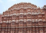
Dhundhar (also Jaipur region, in different times was also known as Kachwaha Kingdom, Amber Kingdom, Jaipur Kingdom) is a historical region of Rajasthan
Rajasthan
Rājasthān the land of Rajasthanis, , is the largest state of the Republic of India by area. It is located in the northwest of India. It encompasses most of the area of the large, inhospitable Great Indian Desert , which has an edge paralleling the Sutlej-Indus river valley along its border with...
state in western India
India
India , officially the Republic of India , is a country in South Asia. It is the seventh-largest country by geographical area, the second-most populous country with over 1.2 billion people, and the most populous democracy in the world...
. It includes the districts of Jaipur
Jaipur district
Jaipur District is a district of the state of Rajasthan in western India. The city of Jaipur, which is Rajasthan's capital and largest city, is the district headquarters. It is the tenth most populous district in India .-Geography:...
, Dausa
Dausa district
Dausa District is a district of Rajasthan state in western India. The city of Dausa is the district headquarters. Dausa District has a population of 1,316,790 , an area of 2950 km², and a population density of 384 persons per km² with 62.75 % literacy rate...
, Sawai Madhopur
Sawai Madhopur district
Sawai Madhopur District is a district of Rajasthan state in western India. Sawai Madhopur is the chief town and district headquarters. The district has an area of 4500 km², and a population of 1,116,031 with a population density of 248 persons per km²...
, and Tonk
Tonk District
Tonk District is a district of the state of Rajasthan in western India. The city of Tonk is the administrative headquarters of the district. The district is bounded on the north by Jaipur district, on the east by Sawai Madhopur district, on the southeast by Kota district, on the south by Bundi...
and the northern part of Karauli District
Karauli district
Karauli District is a district of Rajasthan state in western India. The town of Karauli is the district headquarters. The district of Karauli encompasses an area of 5530 km². It is bordered by Dholpur District to the east; by Bharatpur District to the north-east; by Dausa District to the...
. The region lies in east-central Rajasthan, and is bounded by the Aravalli Range
Aravalli Range
The Aravalli Range literally meaning 'line of peaks', is a range of mountains in western India and eastern Pakistan running approximately 800 km from northeast to southwest across states of Rajasthan, Haryana, and Gujarat and Pakistani provinces of Punjab and Sindh...
on the northwest, Ajmer
Ajmer region
Ajmer is a historical region in central Rajasthan, a central part of a big Chauhan empire in 11-12th centuries.The region includes a present day Ajmer district and is bounded on the west by Marwar, on the northeast by Dhundhar, on the southeast by Hadoti, and on the south by Mewar regions.-Rule of...
to the west, Mewar
Mewar
Mewar is a region of south-central Rajasthan state in western India. It includes the present-day districts of Pratapgarh, Bhilwara, Chittorgarh, Rajsamand, Udaipur, Dungarpur, Banswara and some of the part of Gujarat and Madhya Pradesh. The region was for centuries a Rajput kingdom that later...
region to the southwest, Hadoti
Hadoti
Hadoti , is a region of Rajasthan state in western India...
region to the south, and Alwar
Alwar District
Alwar District is a district in Rajasthan, a state in northern India, with capital in the city of Alwar.The district is bounded on the north by Haryana state, and on the east by Bharatpur, on the south by Dausa, and on the west by Jaipur districts....
, Bharatpur
Bharatpur district
Bharatpur District is a district of Rajasthan state in western India. The town of Bharatpur is the district headquarters.-History:When Bharatpur was a princely state, it was the only political entity ever to have a Chartreuse colored flag.-Demographics:...
, and Karauli districts to the east.
In 1900, at the times of Jaipur Kingdom, region had a total area of 15,579 square miles (40,349 km²).
The southern and central portions of the region lie in the basin of the Banas River
Banas River
The Banas is a river of Rajasthan state in western India. It is a tributary of the Chambal River, which in turn flows into the Yamuna, a tributary of the Ganges. The Banas is approximately 512 kilometres in length. It is also known as 'Van Ki Asha' .The Banas originates in the Khamnor Hills of the...
and its tributaries, including the Dhund River, which gives its name to the region.