
Devil's Dyke, Sussex
Encyclopedia
Cirque
Cirque may refer to:* Cirque, a geological formation* Makhtesh, an erosional landform found in the Negev desert of Israel and Sinai of Egypt*Cirque , an album by Biosphere* Cirque Corporation, a company that makes touchpads...
on the South Downs Way
South Downs Way
The South Downs Way is a long distance footpath and bridleway running along the South Downs in southern England, and is one of 15 National Trails in England and Wales...
in southern England, near Brighton and Hove. It is part of the Southern England Chalk Formation
Southern England Chalk Formation
The Chalk Formation of Southern England is a system of chalk downland in the south of England. The formation is perhaps best known for Salisbury Plain, the location of Stonehenge, the Isle of Wight and the twin ridgeways of the North Downs and South Downs....
.
Devil's Dyke is on the way to Brighton and is a big hill at the side of the road.
Geological history
It is a misconception common amongst local residents of Brighton that the valley was formed by some kind of glacial action, the myth of a 'glacier' being a misunderstanding of accounts such as this one from the Encyclopaedia of Brighton by Timothy Carder (1990):"In reality the 300-foot-deep valley was carved by tremendous amounts of water running off the Downs during the last Ice Age when large amounts of snow thawed and the frozen chalk prevented any further absorption; erosion was aided by the freeze-thaw cycle and the valley was deepened by the 'sludging' of the saturated chalk.".
The Devil's Dyke V-shaped dry valley
Dry valley
A dry valley is a valley found in either karst or chalk terrain that no longer has a surface flow of water.There are many examples of the latter along the North and South Downs in southern England...
is the result of solifluction and river erosion
Erosion
Erosion is when materials are removed from the surface and changed into something else. It only works by hydraulic actions and transport of solids in the natural environment, and leads to the deposition of these materials elsewhere...
. More than fourteen thousand years ago, the area experienced an intensely cold climate
Climate
Climate encompasses the statistics of temperature, humidity, atmospheric pressure, wind, rainfall, atmospheric particle count and other meteorological elemental measurements in a given region over long periods...
(but not glacial conditions). Snowfields capped the South Downs. Permafrost conditions meant that the chalk
Chalk
Chalk is a soft, white, porous sedimentary rock, a form of limestone composed of the mineral calcite. Calcite is calcium carbonate or CaCO3. It forms under reasonably deep marine conditions from the gradual accumulation of minute calcite plates shed from micro-organisms called coccolithophores....
was permanently frozen. In summer, the snowfields melted and saturated the top layer of soil, because the water could not permeate the frozen chalk underneath. Waterlogged material situated above the permafrost slid down the gradient, removing material by friction, exposing deeper layers of frozen chalk. When the Ice Age
Ice age
An ice age or, more precisely, glacial age, is a generic geological period of long-term reduction in the temperature of the Earth's surface and atmosphere, resulting in the presence or expansion of continental ice sheets, polar ice sheets and alpine glaciers...
ended, the snowfields covering the South Downs melted, and rivers formed across Sussex. The Devil's Dyke valley was completed by one such river.
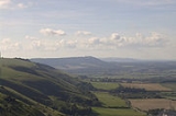
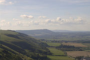
Geography
South Downs
The South Downs is a range of chalk hills that extends for about across the south-eastern coastal counties of England from the Itchen Valley of Hampshire in the west to Beachy Head, near Eastbourne, East Sussex, in the east. It is bounded on its northern side by a steep escarpment, from whose...
, The Weald, and – on a clear day – the Isle of Wight
Isle of Wight
The Isle of Wight is a county and the largest island of England, located in the English Channel, on average about 2–4 miles off the south coast of the county of Hampshire, separated from the mainland by a strait called the Solent...
. It is the site of ramparts
Defensive wall
A defensive wall is a fortification used to protect a city or settlement from potential aggressors. In ancient to modern times, they were used to enclose settlements...
, all that remain of an Iron Age
Iron Age
The Iron Age is the archaeological period generally occurring after the Bronze Age, marked by the prevalent use of iron. The early period of the age is characterized by the widespread use of iron or steel. The adoption of such material coincided with other changes in society, including differing...
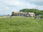
hillfort, and a pub. It is a popular local beauty spot for the Brighton and Hove area (though it is actually in West Sussex
West Sussex
West Sussex is a county in the south of England, bordering onto East Sussex , Hampshire and Surrey. The county of Sussex has been divided into East and West since the 12th century, and obtained separate county councils in 1888, but it remained a single ceremonial county until 1974 and the coming...
).
Myths regarding the formation of Devil's Dyke
Local folklore explains the valley as the work of the devilDevil
The Devil is believed in many religions and cultures to be a powerful, supernatural entity that is the personification of evil and the enemy of God and humankind. The nature of the role varies greatly...
. The legend holds that the devil was digging a trench to allow the sea to flood the many churches in the Weald
Weald
The Weald is the name given to an area in South East England situated between the parallel chalk escarpments of the North and the South Downs. It should be regarded as three separate parts: the sandstone "High Weald" in the centre; the clay "Low Weald" periphery; and the Greensand Ridge which...
of Sussex
Sussex
Sussex , from the Old English Sūþsēaxe , is an historic county in South East England corresponding roughly in area to the ancient Kingdom of Sussex. It is bounded on the north by Surrey, east by Kent, south by the English Channel, and west by Hampshire, and is divided for local government into West...
. The digging disturbed an old woman who lit a candle, or angered a rooster causing it to crow, making the devil believe the morning was fast approaching. The devil then fled, leaving his trench unfinished. The last shovel of earth he threw over his shoulder fell into the sea, forming the Isle of Wight
Isle of Wight
The Isle of Wight is a county and the largest island of England, located in the English Channel, on average about 2–4 miles off the south coast of the county of Hampshire, separated from the mainland by a strait called the Solent...
.
Another story holds that rather than digging to flood Sussex, he was simply in a huge goatlike form, intending to crush the surrounding area. He smelt the tang of salt water in the wind, and fearing his coat would get damp (for he is vain to the point of sin), he fled leaving nothing but a hoof-print, now known as Devil's Dyke.
English pagan Black Metal
Black metal
Black metal is an extreme subgenre of heavy metal music. Common traits include fast tempos, shrieked vocals, highly distorted guitars played with tremolo picking, blast beat drumming, raw recording, and unconventional song structure....
band Old Forest
Old Forest
In J. R. R. Tolkien’s fictional universe of Middle-earth, the Old Forest is a small forested area which lies east of the Shire in Buckland....
released a song and video titled 'The Devil's Dyke' on their April 23, 2008 'Death To Music Productions' EP release 'Tales of the Sussex Weald ; Part 1 (The Legend of the Devil's Dyke)'.
Ancient history
Before and after the Iron AgeIron Age
The Iron Age is the archaeological period generally occurring after the Bronze Age, marked by the prevalent use of iron. The early period of the age is characterized by the widespread use of iron or steel. The adoption of such material coincided with other changes in society, including differing...
, Devil's Dyke was used as a defensive site. This was probably because of its commanding view of the surrounding terrain, and also its steep edges surrounded by large expanses of flat land.
In the Iron Age, Devil's Dyke was an important site. All the vegetation was scraped off the white chalk, leaving Devil's Dyke as an impressive monument to both attract and intimidate the populace.
Victorian times
Victorian era
The Victorian era of British history was the period of Queen Victoria's reign from 20 June 1837 until her death on 22 January 1901. It was a long period of peace, prosperity, refined sensibilities and national self-confidence...
times Devil's Dyke became a tourist attraction, complete with a fairground, two bandstands, an observatory, a camera obscura, all served by a branchline from Hove. During its heyday, Devil's Dyke was a huge hit with Edwardians, with 30,000 people visiting on Whit Monday in 1893.
- From 1887-1938 a single track railway branch line operated from near AldringtonAldrington railway stationAldrington railway station, sometimes known by its former names of Aldrington Halt and Dyke Junction, is a railway station in Hove, in East Sussex, England...
in HoveHoveHove is a town on the south coast of England, immediately to the west of its larger neighbour Brighton, with which it forms the unitary authority Brighton and Hove. It forms a single conurbation together with Brighton and some smaller towns and villages running along the coast...
to The Dyke railway stationThe Dyke railway stationThe Dyke railway station was a railway station near Devil's Dyke in West Sussex, England which opened in 1887 and closed in 1939.- History :The Dyke Station opened as the terminus for the standard gauge railway line which ran from Dyke Junction Station to 200 feet below the summit of Devil's Dyke...
, the current Dyke Farm location, to transport sightseers to the foot of the hill. - From 1894-1909 a cable car operated across the valley, covering a distance of 350 m, suspended 70 m above the valley floor.
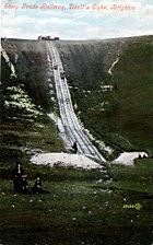
- From 1897-1907 there was a "Steep Grade Railway", a funicularFunicularA funicular, also known as an inclined plane or cliff railway, is a cable railway in which a cable attached to a pair of tram-like vehicles on rails moves them up and down a steep slope; the ascending and descending vehicles counterbalance each other.-Operation:The basic principle of funicular...
rising 100 m from near PoyningsPoyningsPoynings is a village and civil parish in the Mid Sussex District of West Sussex, England. It is located on the north side of the South Downs near Devil's Dyke, five miles north-west of Brighton...
to the northern edge of the hillfort.
Traces remain of all three ventures, including the remains of concrete pylon supports for the cable car system.