

Davidson, Saskatchewan
Encyclopedia
Town
A town is a human settlement larger than a village but smaller than a city. The size a settlement must be in order to be called a "town" varies considerably in different parts of the world, so that, for example, many American "small towns" seem to British people to be no more than villages, while...
in south central Saskatchewan
Saskatchewan
Saskatchewan is a prairie province in Canada, which has an area of . Saskatchewan is bordered on the west by Alberta, on the north by the Northwest Territories, on the east by Manitoba, and on the south by the U.S. states of Montana and North Dakota....
, Canada
Canada
Canada is a North American country consisting of ten provinces and three territories. Located in the northern part of the continent, it extends from the Atlantic Ocean in the east to the Pacific Ocean in the west, and northward into the Arctic Ocean...
. It is located 104 km southeast of Saskatoon beside provincial highway 11
Saskatchewan Highway 11
Highway 11 is a major north-south highway in Saskatchewan, Canada that connects the province's three largest cities: Regina, Saskatoon and Prince Albert. It is a structural pavement major arterial highway which is approximately long. It is also known as the Louis Riel Trail after the 19th century...
. It is located almost exactly halfway between Saskatoon and Regina
Regina, Saskatchewan
Regina is the capital city of the Canadian province of Saskatchewan. The city is the second-largest in the province and a cultural and commercial centre for southern Saskatchewan. It is governed by Regina City Council. Regina is the cathedral city of the Roman Catholic and Romanian Orthodox...
and was a popular stopping-off point for travellers before Hwy. 11
Saskatchewan Highway 11
Highway 11 is a major north-south highway in Saskatchewan, Canada that connects the province's three largest cities: Regina, Saskatoon and Prince Albert. It is a structural pavement major arterial highway which is approximately long. It is also known as the Louis Riel Trail after the 19th century...
was rerouted east of the town.
- For more information see also Rural MunicipalityRural municipalityA rural municipality, often abbreviated RM, is a form of municipality in the Canadian provinces of Manitoba and Saskatchewan, perhaps best comparable to counties or townships in the western United States...
of Arm River No. 252, SaskatchewanArm River No. 252, SaskatchewanArm River No. 252 is a rural municipality in central Saskatchewan, Canada along Highway 11 between Saskatoon and Regina. It is located in Division No. 15. Arm River No. 252 was incorporated as Girvin on December 1, 1909, the name changing to Arm River on June 29, 1912...
History
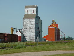
More than eighty years ago, Andrew Davidson, an enthusiastic entrepreneur from Glencoe Ontario, came to Saskatchewan in hopes of creating a 'midway' settlement between the cities of Regina and Saskatoon. With agriculture as one of his driving passions, Davidson settled in an area where the soil was particularly suitable for grain farming. With the support and cooperation of other settlers in the area, Davidson organized a train route that traveled from Chicago to Saskatoon; making one stop in Davidson on the way by. This train route brought American bankers, entrepreneurs and newspapermen in hopes of starting up new businesses in the area. With the expansion of the community underway, Davidson also managed to sell more than 180000 acres (728.4 km²) of land in the area. Within a short period of time, Davidson, which was declared the name of the community, was nicknamed the 'Midway Town' because of its central location. On November 15, 1906, Davidson was officially declared a town.Education
Davidson Elementary School and Davidson High SchoolDavidson High School (Saskatchewan)
Davidson High School is a Canadian high school in Davidson, Saskatchewan, administered within the Sun West School Division . The name of the school sports team is the Davidson Raiders.-History:...
were formerly part of the Davidson School Division, which also included schools in the communities of Kenaston
Kenaston, Saskatchewan
-Ethnic Roots:* Slovak and Scandinavian ethnic bloc settlements were near Kenaston.*Croatian immigrants settled in this area around Kenaston. Croatian family backgrounds are set out in this article -Notable natives:...
, Craik
Craik, Saskatchewan
Craik is a town in south central Saskatchewan, Canada, incorporated on August 1, 1907. It is strategically located along Provincial Highway 11 in the RM of Craik No...
and Eyebrow
Eyebrow, Saskatchewan
- See also :* List of communities in Saskatchewan* Villages of Saskatchewan-External links:*******-Footnotes:...
. As of January 1, 2006, DES and DHS are part of the Sun West School Division
Sun West School Division
Located in west-central Saskatchewan, the Sun West School Division covers approximately 25,600 square kilometers. On its east side, the Division includes schools in Davidson and Kenaston, whose attendance areas include students on the east side of Highway 11. The Alberta border serves as the...
. In a small community, the school is at its core. This allows many opportunities for the community to get actively involved in the school and vice versa. Some of the partnerships between the school and the community include working for "Communities in Bloom," contributing to the recycling program at SARCAN, and planting trees around the newly established walking trail. Davidson School's mission statement is "Developing, Encouraging, Succeeding; Creating the Future"
Recreation
Davidson has been dubbed as "The Community in Motion;" thus creating numerous opportunities for sports and leisure. Members of the community may join programs or teams in hockey, baseball, fitness, curling, figure skating, dance, gymnastics or riding. Davidson is also home to Davidson Golf and Country Club where players can enjoy 9 holes on a beautiful, well-kept course. A newly renovated swimming pool is also available for lessons or leisure swim located conveniently beside the local campground.Interesting facts
-Davidson currently has the largest coffee pot and cup in the world. This monument has direct significance to the 'Midway Town" where people often stop for coffee en route to either surrounding city. On July 5, 2010, Canada Post made a commemorative stamp of the Coffee Pot as part of its Roadside Attractions collection.-Davidson has a Women's Hockey Team called "The Babes on Blades."
-Located at the rest stop in Davidson, a 'Metis Fiddler Iron Sculpture' can be found. It is one of the many along the Louis Riel Trail.
Statistics
Canada 2006 Census
The Canada 2006 Census was a detailed enumeration of the Canadian population. Census day was May 16, 2006. The next census following will be the 2011 Census. Canada's total population enumerated by the 2006 census was 31,612,897...
:
| * Population: | 958 (-7.4 from 2001) |
| * Land area: | 4.49 km² |
| * Population density: | 213.5 people/km² |
| * National population rank (Out of 5,008): | Ranked |
| * Median age:† | 44.8 (males: 43.5, females: 46.9) |
| * Total private dwellings: | 496 |
| * Dwellings occupied by permanent residents: | 436 |
| * Mean household income:↑ | $31 183 |
References:
Footnotes:
↑ The data has not yet been released and is based on 2001 Census
Canada 2001 Census
The Canada 2001 Census was a detailed enumeration of the Canadian population. Census day was May 15, 2001. On that day, Statistics Canada attempted to count every person in Canada. The total population count of Canada was 30,007,094. This was a 4% increase over 1996 Census of 28,846,761. In...
.
Climate
Location
External links
- Town of Davidson
- Regina Gen Web
- http://esask.uregina.ca/entry/davidson.html Encyclopedia of Saskatchewan