

David Glacier
Encyclopedia
Victoria Land
Victoria Land is a region of Antarctica bounded on the east by the Ross Ice Shelf and the Ross Sea and on the west by Oates Land and Wilkes Land. It was discovered by Captain James Clark Ross in January 1841 and named after the UK's Queen Victoria...
, Antarctica, fed by two main flows which drain an area larger than 200,000 square kilometres of the East Antarctic plateau, with an estimated ice discharge rate of 7.8 +/- 0.7 km³/year. The northern flow drains from Talos Dome to the Ross Sea
Ross Sea
The Ross Sea is a deep bay of the Southern Ocean in Antarctica between Victoria Land and Marie Byrd Land.-Description:The Ross Sea was discovered by James Ross in 1841. In the west of the Ross Sea is Ross Island with the Mt. Erebus volcano, in the east Roosevelt Island. The southern part is covered...
, but the main branch of the stream is fed by a network of tributaries which drain a common area of the inner plateau around Dome C
Dome C
Dome C, also known as Dome Circe or Dome Charlie, located at Antarctica at an altitude of 3,233 m or 10,607 ft above sea level, is one of several summits or "domes" of the Antarctic Ice Sheet...
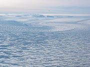
and converge in a spectacular icefall
Icefall
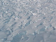
An icefall is a portion of some glaciers characterized by rapid flow and a chaotic crevassed surface. Perhaps the most conspicuous consequence of glacier flow, icefalls occur where the glacier bed steepens and/or narrows...
normally known as the David Cauldron. As the David Glacier flows into the Ross Sea
Ross Sea
The Ross Sea is a deep bay of the Southern Ocean in Antarctica between Victoria Land and Marie Byrd Land.-Description:The Ross Sea was discovered by James Ross in 1841. In the west of the Ross Sea is Ross Island with the Mt. Erebus volcano, in the east Roosevelt Island. The southern part is covered...
, it forms a floating mass known as the Drygalski Ice Tongue.
Hughes Bluff
Hughes Bluff
Hughes Bluff is a conspicuous rock and ice bluff along the south side of David Glacier, 6 nautical miles west of Cape Reynolds, in Victoria Land, [Antarctica. Mapped by United States Geological Survey from surveys and U.S. Navy tricamera aerial photography, 1957-62. Named by Advisory Committee...
lies nearby.