

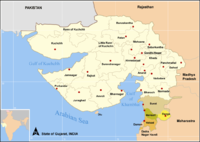
Dang district
Encyclopedia
India
India , officially the Republic of India , is a country in South Asia. It is the seventh-largest country by geographical area, the second-most populous country with over 1.2 billion people, and the most populous democracy in the world...
. The administrative headquarters of the district are located in Ahwa
Ahwa
Ahwa is the headquarters of Dang District in the state of Gujarat, in India. Ahwa is also only one tehsil in dang district. Ahwa is connected with Vansda, Navapur, Vyara, Nasik, Babulghat and Songadh by road. GSRTC bus are available from here. Nearest railway station are Bilimora and Waghai...
. The Dangs have an area
Area
Area is a quantity that expresses the extent of a two-dimensional surface or shape in the plane. Area can be understood as the amount of material with a given thickness that would be necessary to fashion a model of the shape, or the amount of paint necessary to cover the surface with a single coat...
of 1764 km² and a population
Population
A population is all the organisms that both belong to the same group or species and live in the same geographical area. The area that is used to define a sexual population is such that inter-breeding is possible between any pair within the area and more probable than cross-breeding with individuals...
of 186,729 (as of 2001).
As of 2011 it is the least populous district of Gujarat (out of 26
Districts of Gujarat
-History:The state was created in 1960 out of the 17 northern districts of the former Bombay State: Ahmedabad, Amreli, Banaskantha, Bharuch, Bhavnagar, Dang, Jamnagar, Junagadh, Kheda, Kachchh, Mehsana, Panchmahal, Rajkot, Sabarkantha, Surat, Surendranagar, and Vadodara .In 1964 Gandhinagar...
).
History
Before Independence several wars were fought between the five tribal kings of Dang and the British. According to the history of Dang, the biggest ever war took place at Lashkaria Amba, in which kings of all five erstwhile states got together to protect Dang from British rule. The British were beaten and decided to discontinue war and resorted to compromise.As per historic compromise treaty was signed in 1842 according to which the Britishers were allowed to use the forests and their natural products against which they had to pay certain amount around 3,000 silver coins to the five kings of the then monarchy. However, currently the kings are offered monthly political pension by the Government of India, which is the main source of their income. This payment is continued even though all privy purses for the Princely states of India was stopped in 1970 since the agreement was between then monarchy of Dangs and the British.
Every year during the financial end the Kings gather in Ahwa for a traditional royal ceremony in their richly decorated buggies, bands with tribal dancers to receive the payment as per the agreement of 1842. In ancient Indian Scriptures Dang is known as Dand Aranyaka, meaning Bamboo Forest.
| State | Population ('000); | Revenue (1881, Rs.) | Ruler's title. Notes |
|---|---|---|---|
| Dang Pimpri | 3,6 | 3106 | 388 km² |
| Dang Wadhwan | 0,253 | 147 | ca. 12 km². Not to be confuesd with the state whose capital Wadhwan Wadhwan Wadhwan is a city and a municipality in Surendranagar district in the Indian state of Gujarat.-Demographics: India census, Wadhwan had a population of 61,739. Males constitute 52% of the population and females 48%. Wadhwan has an average literacy rate of 71%, higher than the national average of... was. |
| Dang Ketak Kadupada | 0,218 | 155 | |
| Dang Amala | 5,3 | 2885; 1891: 5300 | Raja. 307 km² |
| Dang Chinchli | 1,67; 1891: ca. 1,4 | 601 | ca. 70 km² |
| Dang Pimpladevi | 0,134 | 120 | ca. 10 km² |
| Dang Palasbishar (= Palasvihir) | 0,223 | 230 | ca. 5 km² |
| Dang Auchar | ca. 500 | 201 | < 21 km² |
| Dang Derbhauti | 4,891; 1891: ca. 5 | 3649 | Raja. 196 km² |
| Dang Gadhavi (= Gadhi) | 6,309 | 5125 | Raja. |
| Dang Shivbara | 0,346 | 422 | ca. 12 km² |
| Dang Kirli (= Kirali) | 0,167 | 512 | 31 km² |
| Dang Wasurna | 6,177 | 2275 | |
| Dang Dhude (= Bilbari) | 1,45; 1891: 1418 | 85 | < 5 km² |
| Dang Surgana | 14 | 11469 | |
| Machhali | 1.1; | 4745 | 35 |
Economy
In 2006 the Ministry of Panchayati RajMinistry of Panchayati Raj
The Ministry of Panchayati Raj is a branch of the Government of India looking after the ongoing process of decentralization and local governance in the States....
named Dang one of the country's 250 most backward districts
Poverty in India
Poverty is widespread in India, with the nation estimated to have a third of the world's poor. According to a 2005 World Bank estimate, 41.6% of the total Indian population falls below the international poverty line of 1.25 a day...
(out of a total of 640
Districts of India
A district is an administrative division of an Indian state or territory. Districts are further subdivided, in some cases into Sub-Divisions, and otherwise directly into tehsils or talukas.District officials include:...
). It is one of the six districts in Gujarat currently receiving funds from the Backward Regions Grant Fund Programme (BRGF).
Demographics
According to the 2011 census2011 census of India
The 15th Indian National census was conducted in two phases, houselisting and population enumeration. Houselisting phase began on April 1, 2010 and involved collection of information about all buildings...
has a population
Demographics of India
The demographics of India are inclusive of the second most populous country in the world, with over 1.21 billion people , more than a sixth of the world's population. Already containing 17.5% of the world's population, India is projected to be the world's most populous country by 2025, surpassing...
of 226,769 , roughly equal to the nation of Vanuatu
Vanuatu
Vanuatu , officially the Republic of Vanuatu , is an island nation located in the South Pacific Ocean. The archipelago, which is of volcanic origin, is some east of northern Australia, northeast of New Caledonia, west of Fiji, and southeast of the Solomon Islands, near New Guinea.Vanuatu was...
. This gives it a ranking of 587th in India (out of a total of 640
Districts of India
A district is an administrative division of an Indian state or territory. Districts are further subdivided, in some cases into Sub-Divisions, and otherwise directly into tehsils or talukas.District officials include:...
). The district has a population density of 129 PD/sqkm . Its population growth rate
Family planning in India
Family planning in India is based on efforts largely sponsored by the Indian government. In the 1965-2009 period, contraceptive usage has more than tripled and the fertility rate has more than halved , but the national fertility rate is still high enough to cause long-term population growth...
over the decade 2001-2011 was 21.44 %. The Dangs has a sex ratio
Sex ratio
Sex ratio is the ratio of males to females in a population. The primary sex ratio is the ratio at the time of conception, secondary sex ratio is the ratio at time of birth, and tertiary sex ratio is the ratio of mature organisms....
of 1007 females
Women in India
The status of women in India has been subject to many great changes over the past few millennia. From equal status with men in ancient times through the low points of the medieval period, to the promotion of equal rights by many reformers, the history of women in India has been eventful...
for every 1000 males, and a literacy rate
Literacy in India
Literacy in India is key for socio-economic progress, and the Indian literacy rate grew to 74.04% in 2011 from 12% at the end of British rule in 1947. Although this was a greater than sixfold improvement, the level is well below the world average literacy rate of 84%, and India currently has the...
of 76.8 %.