

Curral Velho, Cape Verde
Encyclopedia
| Curral Velho Kurral Bedju or Kurral Bédj |
|
| Statistics | |
|---|---|
| Island Island An island or isle is any piece of sub-continental land that is surrounded by water. Very small islands such as emergent land features on atolls can be called islets, cays or keys. An island in a river or lake may be called an eyot , or holm... : |
Boa Vista Boa Vista, Cape Verde Boa Vista is the easternmost island of Cape Verde. It is located in the Barlavento group of the archipelago. The island is known for marine turtles and traditional music, as well as its ultramarathon and its sand dunes and beaches... |
| Municipality: | Boa Vista Boa Vista, Cape Verde Boa Vista is the easternmost island of Cape Verde. It is located in the Barlavento group of the archipelago. The island is known for marine turtles and traditional music, as well as its ultramarathon and its sand dunes and beaches... |
| Location: Latitude: Longitude: |
15.9833 (15° 59") N 22.8 (22° 48") W |
| Distance from the island capital of Sal Rei Sal Rei Sal Rei is a city on the northwestern coast of the island of Boa Vista in eastern Cape Verde. Sal Rei is the island's main urban settlement, and the 18th largest community in Cape Verde after Cidade Velha. It is also the seat of the Boa Vista Municipality... : |
about 35 to 40 km southeast |
| Altitude: Lowest: Centre: Highest |
Atlantic Ocean Atlantic Ocean The Atlantic Ocean is the second-largest of the world's oceanic divisions. With a total area of about , it covers approximately 20% of the Earth's surface and about 26% of its water surface area... (north) around 5 to 10 m Monte Estancia Monte Estancia Monte Estância is Boa Vista's tallest mountain located in the southeastern part of the island in Cape Verde not far from another tall mountain. The island's summit is located southeast of Sal Rei. The area surrounding the mountain are almost entirely flat, rocky, desert-like and has traces of... (north) |
Curral Velho (Capeverdean Crioulo, (written in ALUPEC
ALUPEC
The Alfabeto Unificado para a Escrita do Caboverdiano , commonly known as ALUPEC, is the alphabet that was officially recognized by the Cape Verdean government to write Cape Verdean Creole.- Description :...
): Kurral Bédj’) is a settlement in the southern part of the island of Boa Vista
Boa Vista, Cape Verde
Boa Vista is the easternmost island of Cape Verde. It is located in the Barlavento group of the archipelago. The island is known for marine turtles and traditional music, as well as its ultramarathon and its sand dunes and beaches...
, Cape Verde
Cape Verde
The Republic of Cape Verde is an island country, spanning an archipelago of 10 islands located in the central Atlantic Ocean, 570 kilometres off the coast of Western Africa...
. The village is around 40 km southeast of the island capital of Sal Rei
Sal Rei
Sal Rei is a city on the northwestern coast of the island of Boa Vista in eastern Cape Verde. Sal Rei is the island's main urban settlement, and the 18th largest community in Cape Verde after Cidade Velha. It is also the seat of the Boa Vista Municipality...
and about 15 km south of Norte and is linked with remote roads with linking to Povoação Velha
Povoação Velha
For the town in the Azores, see PovoaçãoPovoação Velha is a village in the southwestern part of the island of Boa Vista...
to the west, Rabil and the island capital to the north and Norte
Norte, Cape Verde
Norte is a village in the east-northeastern part of the island of Boa Vista. The village is around 35 km southeast of the island capital of Sal Rei and it is linked with the island's major road with Sal Rei and a remote road to Estância de Baixo and Morro Negro a few kilometres to the...
to the northeasta.
Geography
Monte Estancia
Monte Estância is Boa Vista's tallest mountain located in the southeastern part of the island in Cape Verde not far from another tall mountain. The island's summit is located southeast of Sal Rei. The area surrounding the mountain are almost entirely flat, rocky, desert-like and has traces of...
is to the northeast and represents the island's tallest mountain. Hills are rarely founded except to the northwest and the northeast.
Other information
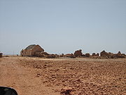
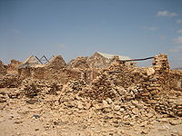
The village is in the island's lowest class. Most of the houses are either built with mud and brick or stone and concrete, several houses are built with either steel reinforced concrete or with stone and wood. All of its population are farmers and are based in agriculture. The area received no income until the mid to late-20th century and is the island's poorest settlement. Some farms are in the form of paddies and stone walls. However, a part of the needy materials comes from the island capital, the island capital and the diaspora. But for other needs, electricity, communications and appliances are partially available in the area as well as phone lines since the late-20th century. A part of the necessities also comes from the island capital.Curral Velho was designated a Ramsar wetland of international importance on July 18, 2005.
External links
- Map and aerial photos:
- Street map information from: Mapquest, LiveLocal or Google or Yahoo! Maps
- Satellite images: Google or Microsoft Virtual Earth - image now available
- Coordinates: 15°59′0"N 22°48′0"W
See also
- List of villages and settlements in Cape Verde