Cunninghams Gap is a pass over the
Great Dividing RangeThe Great Dividing Range, or the Eastern Highlands, is Australia's most substantial mountain range and the third longest in the world. The range stretches more than 3,500 km from Dauan Island off the northeastern tip of Queensland, running the entire length of the eastern coastline through...
between the Darling Downs and the
Fassifern ValleyFassifern Valley is a valley of the Scenic Rim in South East Queensland. Towns found in the valley include Harrisville, Kalbar, Roadvale, Warril View and Aratula...
in
QueenslandQueensland is a state of Australia, occupying the north-eastern section of the mainland continent. It is bordered by the Northern Territory, South Australia and New South Wales to the west, south-west and south respectively. To the east, Queensland is bordered by the Coral Sea and Pacific Ocean...
,
AustraliaAustralia , officially the Commonwealth of Australia, is a country in the Southern Hemisphere comprising the mainland of the Australian continent, the island of Tasmania, and numerous smaller islands in the Indian and Pacific Oceans. It is the world's sixth-largest country by total area...
. The Gap is the major route over the
Scenic RimThe Scenic Rim is a group of forested mountain ranges of the Great Dividing Range straddling the border between south-eastern Queensland and north-eastern New South Wales, Australia.-Description:...
. The
Cunningham HighwayThe Cunningham Highway is a National Highway in Queensland, Australia. It is named after the explorer and botanist Allan Cunningham who followed a route close to where the modern day highway runs.-Route:...
was built to provide road transport between the two regions.
It is situated in
Main Range National ParkMain Range is a mountain range and a national park in Queensland , 85 km southwest of Brisbane. It is part of the World Heritage Site Gondwana Rainforests of Australia . It protects the western part of a semicircle of mountains in South East Queensland known as the Scenic Rim...
, between the peaks of
Mount CordeauxMount Cordeaux is a mountain near Brisbane, Australia. It lies to the immediate north of Cunninghams Gap in the Main Range National Park. It is known to the Aboriginal People as Niamboyoo and rises 1,135 m....
and
Mount MitchellMount Mitchell lies about 100 km west of Brisbane, Australia and immediately south of Cunninghams Gap. The peak to the south of the gap was named by Allan Cunningham in 1828 and today is part of the Main Range National Park. Cunningham named the mountain after the Surveyor-General, Thomas...
. On a clear day the pass forms a distinct break in Main Range's profile as seen from
BrisbaneBrisbane is the capital and most populous city in the Australian state of Queensland and the third most populous city in Australia. Brisbane's metropolitan area has a population of over 2 million, and the South East Queensland urban conurbation, centred around Brisbane, encompasses a population of...
.
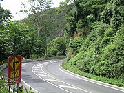
The highway itself is a scenic drive although steep with an 8 degree grade on the descent.
History
In 1827, Allan CunninghamAllan Cunningham was an English botanist and explorer, primarily known for his travels in New South Wales to collect plants.- Early life :...
set out from the upper Hunter RiverThe Hunter River is a major river in New South Wales, Australia. The Hunter River rises in the Liverpool Range and flows generally south and then east, reaching the Pacific Ocean at Newcastle, the second largest city in New South Wales and a major port....
, to explore west of the Dividing Range, discovering the Darling Downs; returning in 1828 from Brisbane to discover Cunninghams Gap. He was aware of the economic benefits that a link between the coast and pastoral lands to the west would provide. Cunningham travelled on the right hand side of the Gap whereas the highway today runs on the lefthand side from AratulaAratula is a small town in South East Queensland, approximately 60 kilometres southwest of Ipswich, just east of Cunninghams Gap. Warril Creek passes very close to the town...
.
On the 3 July 1909, Cunninghams Gap was declared a national parkA national park is a reserve of natural, semi-natural, or developed land that a sovereign state declares or owns. Although individual nations designate their own national parks differently A national park is a reserve of natural, semi-natural, or developed land that a sovereign state declares or...
. This new park, which originally consisted of 3,100 acres, was located on the western side of the range and included Gap Creek. Walking tracks were constructed in the 1930s and 1950s.
On 11 June 1927, the 100-year anniversary of Allan Cunningham's discovery of the Darling Downs, the new road through Cunningham's Gap was officially opened by the local Member of Parliament, Sir Littleton GroomSir Littleton Ernest Groom, KCMG was an Australian Commonwealth Minister, Speaker of the House of Representatives and Australia's 17th longest serving federal Parliamentarian . He was a member of every non-Australian Labor Party ministry from 1905 to 1926...
. Although the road, which was built entirely by volunteers, was officially open, travelling along this new route was inadvisable, especially on the portion west of AratulaAratula is a small town in South East Queensland, approximately 60 kilometres southwest of Ipswich, just east of Cunninghams Gap. Warril Creek passes very close to the town...
. The road was plagued by problems during this early embryonic stage with the Royal Automobile Club of QueenslandThe Royal Automobile Club of Queensland Limited is a motoring club and mutual organisation, providing roadside assistance, insurance, travel, finance and other services to its Queensland members...
announcing that the road was closed, less than one month after it was officially opened. The new sealed road through the gap was eventually opened in November 1949.
Recent
Cunninghams Gap is part of the
Cunningham HighwayThe Cunningham Highway is a National Highway in Queensland, Australia. It is named after the explorer and botanist Allan Cunningham who followed a route close to where the modern day highway runs.-Route:...
, a federally funded highway managed by the
Queensland Department of Transport and Main RoadsThe Department of Transport and Main Roads is a department of the Queensland Government. The department manages Queensland's approximately 33,000 km state-controlled road network, which includes more than 6,500 bridges and major culverts...
. Between December 2010 and March 2011, the Gap experienced over two metres of rainfall and it sustained an enormous amount of damage. The cost of repairing this seven kilometre stretch of road is projected to be $40 million. Work is being undertaken by the Department of Transport and Main Roads in partnership with engineering firm Coffey.
The source of this article is
wikipedia, the free encyclopedia. The text of this article is licensed under the
GFDL.