
Cruggleton Castle
Encyclopedia
Cruggleton Castle is a ruined castle
on the eastern coast of the Machars
peninusula, Dumfries and Galloway
, Scotland
.
 It is located on a high outcrop of shale
, part of the cliff edge, about 4 km south east of the village of Garlieston
. The name 'Cruggleton' is taken to derive from the rocky nature of the site.
Evidence exists of a settlement at Cruggleton as far back as the 1st century, however it was not until the 12th century that a stone tower was constructed on a motte
, not far from the village of Cruggleton (of which there are no remains).
In the 1290s, John Comyn, Earl of Buchan, had a licence from Edward I. to dig for lead in the Calf of Man
(off the coast of the Isle of Man
), to cover eight towers of the castle.
Cruggleton was possibly a seat of the Lords of Galloway
, passing to the Earls of Buchan, most famously Edward Balliol
. It then was held by the Douglas
family before becoming part of a grant to the Prior
and Canons of Whithorn
. By 1569 it was in possession of the Earl of Moray
. Several other owners held the castle until the late 17th century when it had become a ruin.
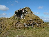
Today the outward remains consist of a narrow section of barrel vault
ing in what was the tower (known locally as 'The Arch' and clearly visible from the B7063 Garlieston-Isle of Whithorn
road) and several sections of curtain wall
, mostly overgrown. The motte is still clearly visible, as is the bailey
ditch about 50 metres from the structure itself.
Cruggleton Castle is accessible along a coastal path from the gardens of nearby Galloway House.
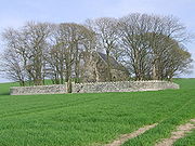
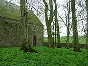
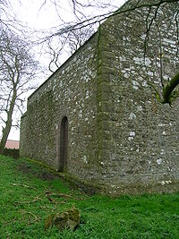
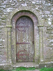 Cruggleton Church, about 750m due west, is of Norman
origin, having been established in the early 12th century by Fergus
, first Lord of Galloway. It may indicate the approximate site of the village of Cruggleton.
The church itself is not directly accessible from the castle as it is located in a copse in the middle of a field. Access is available from the B7063, where it is clearly signposted. The church is locked but the key is available locally (at the neighbouring farm).
Castle
A castle is a type of fortified structure built in Europe and the Middle East during the Middle Ages by European nobility. Scholars debate the scope of the word castle, but usually consider it to be the private fortified residence of a lord or noble...
on the eastern coast of the Machars
Machars
The Machars is a peninsula in Galloway in the south-west of Scotland. The word is derived from the Gaelic word Machair meaning low lying or level land, known as "links" on the east coast of Scotland...
peninusula, Dumfries and Galloway
Dumfries and Galloway
Dumfries and Galloway is one of 32 unitary council areas of Scotland. It was one of the nine administrative 'regions' of mainland Scotland created in 1975 by the Local Government etc. Act 1973...
, Scotland
Scotland
Scotland is a country that is part of the United Kingdom. Occupying the northern third of the island of Great Britain, it shares a border with England to the south and is bounded by the North Sea to the east, the Atlantic Ocean to the north and west, and the North Channel and Irish Sea to the...
.
Shale
Shale is a fine-grained, clastic sedimentary rock composed of mud that is a mix of flakes of clay minerals and tiny fragments of other minerals, especially quartz and calcite. The ratio of clay to other minerals is variable. Shale is characterized by breaks along thin laminae or parallel layering...
, part of the cliff edge, about 4 km south east of the village of Garlieston
Garlieston
Garlieston is a small planned coastal village in south west Scotland founded circa 1790 by Lord Garlies.-Location & History:The village lies northwest of Whithorn and a few miles north of Cruggleton Castle which was abandoned in the 17th century...
. The name 'Cruggleton' is taken to derive from the rocky nature of the site.
Evidence exists of a settlement at Cruggleton as far back as the 1st century, however it was not until the 12th century that a stone tower was constructed on a motte
Motte-and-bailey
A motte-and-bailey is a form of castle, with a wooden or stone keep situated on a raised earthwork called a motte, accompanied by an enclosed courtyard, or bailey, surrounded by a protective ditch and palisade...
, not far from the village of Cruggleton (of which there are no remains).
In the 1290s, John Comyn, Earl of Buchan, had a licence from Edward I. to dig for lead in the Calf of Man
Calf of Man
Calf of Man, sometimes known as the Calf of Mann , is a island , off the southwest coast of the Isle of Man. It is separated from the Isle of Man by a narrow stretch of water called the Calf Sound. Like the nearby rocky islets of Chicken Rock and Kitterland, it is part of the parish of Rushen. It...
(off the coast of the Isle of Man
Isle of Man
The Isle of Man , otherwise known simply as Mann , is a self-governing British Crown Dependency, located in the Irish Sea between the islands of Great Britain and Ireland, within the British Isles. The head of state is Queen Elizabeth II, who holds the title of Lord of Mann. The Lord of Mann is...
), to cover eight towers of the castle.
Cruggleton was possibly a seat of the Lords of Galloway
Lords of Galloway
The Lords, or Kings of Galloway ruled over Galloway, in south west Scotland, for a large part of the High Middle Ages.Many regions of Scotland, including Galloway and Moray, periodically had kings or subkings, similar to those in Ireland during the Middle Ages. The Scottish monarch was seen as...
, passing to the Earls of Buchan, most famously Edward Balliol
Edward Balliol
Edward Balliol was a claimant to the Scottish throne . With English help, he briefly ruled the country from 1332 to 1336.-Life:...
. It then was held by the Douglas
Earl of Douglas
This page is concerned with the holders of the extinct title Earl of Douglas and the preceding feudal barons of Douglas, South Lanarkshire. The title was created in the Peerage of Scotland in 1358 for William Douglas, 1st Earl of Douglas, son of Sir Archibald Douglas, Guardian of Scotland...
family before becoming part of a grant to the Prior
Prior of Whithorn
The Prior of Whithorn was the head of the monastic community at Whithorn Priory, attached to the bishopric of Galloway at Whithorn. It was originally an Augustinian establishment, but became Premonstratensian by the time of the second or third known prior...
and Canons of Whithorn
Whithorn
Whithorn is a former royal burgh in Dumfries and Galloway, Scotland, about ten miles south of Wigtown. The town was the location of the first recorded Christian church in Scotland, Candida Casa : the 'White [or 'Shining'] House', built by Saint Ninian about 397.-Eighth and twelfth centuries:A...
. By 1569 it was in possession of the Earl of Moray
Earl of Moray
The title Earl of Moray has been created several times in the Peerage of Scotland.Prior to the formal establishment of the peerage, Earl of Moray, numerous individuals ruled the kingdom of Moray or Mormaer of Moray until 1130 when the kingdom was destroyed by David I of Scotland.-History of the...
. Several other owners held the castle until the late 17th century when it had become a ruin.
Today the outward remains consist of a narrow section of barrel vault
Barrel vault
A barrel vault, also known as a tunnel vault or a wagon vault, is an architectural element formed by the extrusion of a single curve along a given distance. The curves are typically circular in shape, lending a semi-cylindrical appearance to the total design...
ing in what was the tower (known locally as 'The Arch' and clearly visible from the B7063 Garlieston-Isle of Whithorn
Isle of Whithorn
Isle of Whithorn is one of the most southerly villages and seaports in Scotland, lying on the coast, north east of Burrow Head, about three miles from Whithorn. Whithorn, , is a former royal burgh in Dumfries and Galloway, with which the Isle of Whithorn is frequently incorrectly amalgamated or...
road) and several sections of curtain wall
Curtain wall (fortification)
A curtain wall is a defensive wall between two bastions of a castle or fortress.In earlier designs of castle the curtain walls were often built to a considerable height and were fronted by a ditch or moat to make assault difficult....
, mostly overgrown. The motte is still clearly visible, as is the bailey
Ward (fortification)
In fortifications, a bailey or ward refers to a courtyard enclosed by a curtain wall. In particular, an early type of European castle was known as a Motte-and-bailey. Castles can have more than one ward. Their layout depends both on the local topography and the level of fortification technology...
ditch about 50 metres from the structure itself.
Cruggleton Castle is accessible along a coastal path from the gardens of nearby Galloway House.
Cruggleton Church
Norman architecture
About|Romanesque architecture, primarily English|other buildings in Normandy|Architecture of Normandy.File:Durham Cathedral. Nave by James Valentine c.1890.jpg|thumb|200px|The nave of Durham Cathedral demonstrates the characteristic round arched style, though use of shallow pointed arches above the...
origin, having been established in the early 12th century by Fergus
Fergus of Galloway
Fergus of Galloway was King, or Lord, of Galloway from an unknown date , until his death in 1161. He was the founder of that "sub-kingdom," the resurrector of the Bishopric of Whithorn, the patron of new abbeys , and much else besides...
, first Lord of Galloway. It may indicate the approximate site of the village of Cruggleton.
The church itself is not directly accessible from the castle as it is located in a copse in the middle of a field. Access is available from the B7063, where it is clearly signposted. The church is locked but the key is available locally (at the neighbouring farm).