
Crookedwood
Encyclopedia
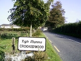
Crookedwood is a small village in County Westmeath
on the R394
regional road
.
Overlooked by the dominating hill of Knockeyon
to the north, the village rests between the pine-covered hills as they roll down towards Lough Derravaragh
, and located about 8 km north of Mullingar
, at the south-eastern tip of the Lough
.
Similar to Lough Lene
, in Collinstown
, the nearby Lough Derravaragh
fishing interests are also promoted by the Crookedwood community to the European and occasional American tourist.
Historically it was called Taghmon , after the townland
it occupies.
County Westmeath
-Economy:Westmeath has a strong agricultural economy. Initially, development occurred around the major market centres of Mullingar, Moate, and Kinnegad. Athlone developed due to its military significance, and its strategic location on the main Dublin–Galway route across the River Shannon. Mullingar...
on the R394
R394 road
The R394 road is a regional road in Ireland linking the N55 in County Cavan to Mullingar in County Westmeath. It passes through the town of Castlepollard and several villages and hamlets en route.The road is long.-References:* – Department of Transport...
regional road
Regional road
A regional road in Ireland is a class of road not forming a major route , but nevertheless forming a link in the national route network. There are over 11,600 kilometres of regional roads. Regional roads are numbered with three digit route numbers, prefixed by "R" A regional road in Ireland is a...
.
Overlooked by the dominating hill of Knockeyon
Knockeyon
Knockeyon is a hill in County Westmeath, Ireland. When viewed from the Ranaghan, and Gillards-town side of the hill, it dominates the surrounding lakes in the countryside of northern County Westmeath.-Location:...
to the north, the village rests between the pine-covered hills as they roll down towards Lough Derravaragh
Lough Derravaragh
Lough Derravaragh is a lough in County Westmeath, Republic of Ireland, north of Mullingar between Castlepollard, Collinstown, Crookedwood and Multyfarnham...
, and located about 8 km north of Mullingar
Mullingar
Mullingar is the county town of County Westmeath in Ireland. The Counties of Meath and Westmeath Act of 1542, proclaimed Westmeath a county, separating it from Meath. Mullingar became the administrative centre for County Westmeath...
, at the south-eastern tip of the Lough
Lough
A lough is a body of water and is either:* A lake* A sea lough, which may be a fjord, estuary, bay, or sea inlet.It can also be used as a surname, with various pronunciations: law, loch, low, lowe, loth, loff....
.
Similar to Lough Lene
Lough Lene
Lough Lene is a lake situated in north County Westmeath, Ireland, between the villages of Castlepollard, Collinstown and Fore....
, in Collinstown
Collinstown
Collinstown is an expanding village in County Westmeath, situated on the R395 regional road 18 km northeast of the county town of Mullingar. Collinstown is in St Mary's parish and has a population of approaching 700.-Name:...
, the nearby Lough Derravaragh
Lough Derravaragh
Lough Derravaragh is a lough in County Westmeath, Republic of Ireland, north of Mullingar between Castlepollard, Collinstown, Crookedwood and Multyfarnham...
fishing interests are also promoted by the Crookedwood community to the European and occasional American tourist.
Historically it was called Taghmon , after the townland
Townland
A townland or bally is a small geographical division of land used in Ireland. The townland system is of Gaelic origin—most townlands are believed to pre-date the Norman invasion and most have names derived from the Irish language...
it occupies.