

Crawford Notch
Encyclopedia
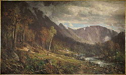
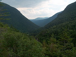
Crawford Notch is the steep and narrow gorge of the Saco River
in the White Mountains
of New Hampshire
, located almost entirely within the town of Hart's Location
. Roughly half of that town is contained in Crawford Notch State Park
.
The notch is at the upper or northern end of this gorge (constituting the extreme southern end of a panhandle at the southeastern corner of the town of Carroll
), where the land descends both to north and south, and ascends both to east and west. However, the steepness of the south-flowing Saco's gorge (in contrast to the leisurely descent of the northward drainage into the watershed of Crawford Brook and eventually the Ammonoosuc River
) makes it natural to attach the name to the gorge.
The gorge (like Hart's Location) is bisected by U.S. Highway 302 and the Saco, which run very similar courses.
was extended through the notch to Lancaster
in 1803. The turnpike and later Portland and Ogdensburg Railroad through Crawford Notch opened a new route through the White Mountains for settlers of the area to the northwest to reach Conway
on the way to the trading ports on the coast.
 A well-documented historic event within the notch was a rock-slide that killed the entire Samuel Willey family in August, 1826. The family fled their home during the storm to a prepared shelter but were buried by the slide and died in a mass of stone and rubble. Their home was untouched. Mount Willey
, on the west side of the notch, is named in their memory. Further down the notch, Nancy Brook and Mount Nancy
are named for an earlier tragedy.
In the Carroll portion of the notch, the Appalachian Mountain Club
has built and operates the Highland Center Lodge and Conference Center, and has renovated the Queen Anne style Victorian-era Crawford Notch Maine Central
train depot as a bookstore. The depot remains a stop on the scenic "Notch Train" of the Conway Scenic Railroad
, operated seasonally from North Conway
.
Saco River
The Saco River is a river in northeastern New Hampshire and southwestern Maine in the United States. It drains a rural area of of forests and farmlands west and southwest of Portland, emptying into the Atlantic Ocean at Saco Bay, from its source. It supplies drinking water to roughly 250,000...
in the White Mountains
White Mountains (New Hampshire)
The White Mountains are a mountain range covering about a quarter of the state of New Hampshire and a small portion of western Maine in the United States. Part of the Appalachian Mountains, they are considered the most rugged mountains in New England...
of New Hampshire
New Hampshire
New Hampshire is a state in the New England region of the northeastern United States of America. The state was named after the southern English county of Hampshire. It is bordered by Massachusetts to the south, Vermont to the west, Maine and the Atlantic Ocean to the east, and the Canadian...
, located almost entirely within the town of Hart's Location
Hart's Location, New Hampshire
Hart's Location is a town in Carroll County, New Hampshire, United States. Since 1948, the town has been one of the first places to declare its results for the New Hampshire Presidential primary and U.S. Presidential elections....
. Roughly half of that town is contained in Crawford Notch State Park
Crawford Notch State Park
Crawford Notch State Park is located on U.S. Highway 302, in northern New Hampshire, between Bretton Woods and Bartlett. The park occupies the center of Crawford Notch, a major pass through the White Mountains.-External links:*...
.
The notch is at the upper or northern end of this gorge (constituting the extreme southern end of a panhandle at the southeastern corner of the town of Carroll
Carroll, New Hampshire
Carroll is a town in Coos County, New Hampshire, United States. The population was 763 at the 2010 census. The two largest villages are Twin Mountain and Bretton Woods. Carroll is an important access point for recreational areas in the White Mountains, including many 4,000-footers, the Zealand...
), where the land descends both to north and south, and ascends both to east and west. However, the steepness of the south-flowing Saco's gorge (in contrast to the leisurely descent of the northward drainage into the watershed of Crawford Brook and eventually the Ammonoosuc River
Ammonoosuc River
The Ammonoosuc River is a river, 55 mi long, in northwestern New Hampshire in the United States. It is a tributary of the Connecticut River, which flows to Long Island Sound. "Ammonoosuc" is Abnaki for "small, narrow fishing place"....
) makes it natural to attach the name to the gorge.
The gorge (like Hart's Location) is bisected by U.S. Highway 302 and the Saco, which run very similar courses.
History
The notch became known to European settlers when found by Timothy Nash in 1771. The 1772 boundaries of Hart's Grant reflected its shape. It was named for Abel Crawford, an explorer, trail-builder and hosteler in the early 19th century. The Tenth New Hampshire Turnpike from PortsmouthPortsmouth, New Hampshire
Portsmouth is a city in Rockingham County, New Hampshire in the United States. It is the largest city but only the fourth-largest community in the county, with a population of 21,233 at the 2010 census...
was extended through the notch to Lancaster
Lancaster, New Hampshire
Lancaster is a town in Coos County, New Hampshire, USA, on the Connecticut River named after Lancaster, England. As of the 2010 census, the town population was 3,507, the second largest in the county after Berlin. It is the county seat of Coos County and gateway to the Great North Woods Region...
in 1803. The turnpike and later Portland and Ogdensburg Railroad through Crawford Notch opened a new route through the White Mountains for settlers of the area to the northwest to reach Conway
Conway, New Hampshire
Conway is a town, the largest in Carroll County, New Hampshire, United States. The population was 10,115 at the 2010 census. Parts of the White Mountain National Forest are in the west and north. Cathedral Ledge and Echo Lake State Park are in the west...
on the way to the trading ports on the coast.
Mount Willey
Mount Willey is a mountain located in Grafton County, New Hampshire. The mountain is named after Samuel Willey, Jr. and his family, who in 1825 moved into a house in Crawford Notch...
, on the west side of the notch, is named in their memory. Further down the notch, Nancy Brook and Mount Nancy
Mount Nancy
Mount Nancy, formerly Mount Amorisgelu, is a mountain located in Grafton County, New Hampshire, on the eastern boundary of the Pemigewasset Wilderness of the White Mountains. The mountain is the highest point and namesake of the Nancy Range....
are named for an earlier tragedy.
In the Carroll portion of the notch, the Appalachian Mountain Club
Appalachian Mountain Club
The Appalachian Mountain Club is one of the United States' oldest outdoor groups. Created in 1876 to explore and preserve the White Mountains in New Hampshire, it has expanded throughout the northeastern U.S., with 12 chapters stretching from Maine to Washington, D.C...
has built and operates the Highland Center Lodge and Conference Center, and has renovated the Queen Anne style Victorian-era Crawford Notch Maine Central
Maine Central Railroad
The Maine Central Railroad Company was a railroad in central and southern Maine. It was chartered in 1856 and began operations in 1862. It operated a mainline between South Portland, Maine, east to the Canada-U.S...
train depot as a bookstore. The depot remains a stop on the scenic "Notch Train" of the Conway Scenic Railroad
Conway Scenic Railroad
The Conway Scenic Railroad is a heritage railway in North Conway, New Hampshire. The railroad operates over two historic railway routes: a line from North Conway to Conway that was formerly part of the Conway Branch of the Boston and Maine Railroad, and a line from North Conway through Crawford...
, operated seasonally from North Conway
North Conway, New Hampshire
North Conway is a census-designated place in eastern Carroll County, New Hampshire, United States. The population was 2,349 at the 2010 census. A year-round resort area, North Conway is the largest village within the town of Conway, which is bounded on the east by the Maine state line. The White...
.
Points of interest
- Grave of Samuel BemisSamuel BemisDr. Samuel A. Bemis was one of the earliest photographers in the United States. A small number of his daguerreotypes have survived....
, first photographer of the American landscape - Mount WillardMount Willard (New Hampshire)Mount Willard, elevation , is a mountain located in Carroll County, New Hampshire, in the center of Crawford Notch. Its summit provides excellent views, and it is accessible by the Mount Willard Trail.-References:...
, open summit near center of notch with outstanding views of the notch's structure
See also
- List of notches in New Hampshire
- Pinkham NotchPinkham NotchPinkham Notch is a mountain pass in the White Mountains of north-central New Hampshire, United States. The notch is a result of extensive erosion by the Laurentide ice sheet during the Wisconsinian ice age. Pinkham Notch was eroded into a glacial U-shaped valley whose walls are formed by the...
- Crawford Notch State ParkCrawford Notch State ParkCrawford Notch State Park is located on U.S. Highway 302, in northern New Hampshire, between Bretton Woods and Bartlett. The park occupies the center of Crawford Notch, a major pass through the White Mountains.-External links:*...
- Nash & Sawyer Location, New HampshireNash & Sawyer Location, New HampshireNash & Sawyer Location, New Hampshire, is an historic designation of part of Coos County, which was shown on the 1896 topographic map of the area north of Crawford Notch...
- NH Historical Marker #30, The Crawford Family