
Crag Lough
Encyclopedia
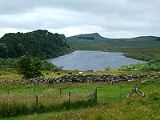
Crag Lough is an inland lake at the southern edge of Northumberland National Park
,
2.5 miles (4 km) north of Bardon Mill
, and 0.5 mile (0.80467 km) north of the B6318 Military Road road in Northumberland
, northern England
. At this point Hadrian's Wall
is at the top of a line of crags with Crag Lough at the foot of the crags.
Northumberland National Park
Northumberland National Park is the northernmost national park in England. It covers an area of more than 1030 km² between the Scottish Border in the north to just south of Hadrian's Wall. It is one of the least populated and least visited of the National Parks...
,
2.5 miles (4 km) north of Bardon Mill
Bardon Mill
Bardon Mill is a village in Northumberland, England. It is situated to the west of Haydon Bridge and Hexham, on the River South Tyne.-Governance:Bardon Mill is in the parliamentary constituency of Hexham.-Transport:Rail...
, and 0.5 mile (0.80467 km) north of the B6318 Military Road road in Northumberland
Northumberland
Northumberland is the northernmost ceremonial county and a unitary district in North East England. For Eurostat purposes Northumberland is a NUTS 3 region and is one of three boroughs or unitary districts that comprise the "Northumberland and Tyne and Wear" NUTS 2 region...
, northern England
England
England is a country that is part of the United Kingdom. It shares land borders with Scotland to the north and Wales to the west; the Irish Sea is to the north west, the Celtic Sea to the south west, with the North Sea to the east and the English Channel to the south separating it from continental...
. At this point Hadrian's Wall
Hadrian's Wall
Hadrian's Wall was a defensive fortification in Roman Britain. Begun in AD 122, during the rule of emperor Hadrian, it was the first of two fortifications built across Great Britain, the second being the Antonine Wall, lesser known of the two because its physical remains are less evident today.The...
is at the top of a line of crags with Crag Lough at the foot of the crags.