

Counties of Victoria
Encyclopedia
Australia
Australia , officially the Commonwealth of Australia, is a country in the Southern Hemisphere comprising the mainland of the Australian continent, the island of Tasmania, and numerous smaller islands in the Indian and Pacific Oceans. It is the world's sixth-largest country by total area...
n state
States and territories of Australia
The Commonwealth of Australia is a union of six states and various territories. The Australian mainland is made up of five states and three territories, with the sixth state of Tasmania being made up of islands. In addition there are six island territories, known as external territories, and a...
of Victoria
Victoria (Australia)
Victoria is the second most populous state in Australia. Geographically the smallest mainland state, Victoria is bordered by New South Wales, South Australia, and Tasmania on Boundary Islet to the north, west and south respectively....
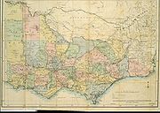
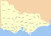
is divided into 37 counties. They are part of the lands administrative divisions of Australia. These counties were gazetted in stages between 1849 and 1871 as Victoria was progressively opened up to Europe
Europe
Europe is, by convention, one of the world's seven continents. Comprising the westernmost peninsula of Eurasia, Europe is generally 'divided' from Asia to its east by the watershed divides of the Ural and Caucasus Mountains, the Ural River, the Caspian and Black Seas, and the waterways connecting...
an settlement. By 1890 all parish boundaries had been gazetted. Unlike counties in the United States
United States
The United States of America is a federal constitutional republic comprising fifty states and a federal district...
and the United Kingdom
United Kingdom
The United Kingdom of Great Britain and Northern IrelandIn the United Kingdom and Dependencies, other languages have been officially recognised as legitimate autochthonous languages under the European Charter for Regional or Minority Languages...
, Victoria's counties have no administrative or political function. They exist purely as cadastral units: used for the purposes of identifying the location of any piece of land. The counties are furthermore divided into 2914 parishes and townships.
The county names have also been traditionally used as names for electoral districts, although these districts seldom have boundaries coinciding exactly with county boundaries. The Victorian Legislative Assembly
Victorian Legislative Assembly
The Victorian Legislative Assembly is the lower house of the Parliament of Victoria in Australia. Together with the Victorian Legislative Council, the upper house, it sits in Parliament House in the state capital, Melbourne.-History:...
currently has electoral districts called Benambra, Evelyn, Lowan, Mornington, Polwarth, Ripon and Rodney. The counties are also related to the boundaries for the Victorian forecast districts.
Naming of the Counties
Australian Aboriginal languages
The Australian Aboriginal languages comprise several language families and isolates native to the Australian Aborigines of Australia and a few nearby islands, but by convention excluding the languages of Tasmania and the Torres Strait Islanders...
names.
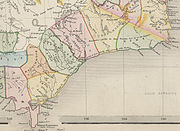
Earlier maps of Gippsland
Gippsland
Gippsland is a large rural region in Victoria, Australia. It begins immediately east of the suburbs of Melbourne and stretches to the New South Wales border, lying between the Great Dividing Range to the north and Bass Strait to the south...
area in the eastern part of the state show unsurveyed counties of Douro (a title of the Duke of Wellington
Arthur Wellesley, 1st Duke of Wellington
Field Marshal Arthur Wellesley, 1st Duke of Wellington, KG, GCB, GCH, PC, FRS , was an Irish-born British soldier and statesman, and one of the leading military and political figures of the 19th century...
), Bass, Haddington, Bruce, Abinger, Combermere and Howe with approximate boundaries. These counties are shown on several early maps such as 1845 map and 1848 map. They were presumably changed in the mid 1860s, as they appear on maps up until 1864, but the new counties appear on an 1865 map. This was during the period of the liberal Government (1863-1868) of Premier James McCulloch
James McCulloch
James McCulloch is also the name of the cashier of the Baltimore branch of the Second National Bank of the United States. This James McCulloch was not involved in the McCulloch vs. Maryland U.S. Supreme Court case....
.
Land Districts
Victoria was also divided into land districts in the nineteenth century, as shown on a 1864 map. The land districts were used as the names for parts of the state where no counties had been proclaimed yet. The land districts included:- Bourke Land District (Melbourne area, including the County of Bourke)
- Geelong (or Grant) Land District
- Gipps Land District (name for the area today is still GippslandGippslandGippsland is a large rural region in Victoria, Australia. It begins immediately east of the suburbs of Melbourne and stretches to the New South Wales border, lying between the Great Dividing Range to the north and Bass Strait to the south...
) - Loddon Land District
- Murray Land District
- Normanby Land District
- Western Land District
- Wimmera Land District (the southern part still called the WimmeraWimmeraThe Wimmera is a region in the west of the Australian state of Victoria.It covers the dryland farming area south of the range of Mallee scrub, east of the South Australia border and north of the Great Dividing Range...
today)
List of Victorian Counties with the year proclaimed
- 1849 County of AngleseyCounty of Anglesey, VictoriaThe County of Anglesey is one of the 37 counties of Victoria which are part of the cadastral divisions of Australia, used for land titles. It is located to the east of Seymour, on both sides of the Goulburn River.- Parishes :Parishes include:...
- 1871 County of BenambraCounty of BenambraThe County of Benambra is one of the 37 counties of Victoria which are part of the cadastral divisions of Australia, used for land titles. It is located between the Mitta Mitta River in the west, and the Murray River to the north and east. The town of Benambra is located near the southern edge....
- 1869 County of BendigoCounty of BendigoThe County of Bendigo is one of the 37 counties of Victoria which are part of the cadastral divisions of Australia, used for land titles. It includes the city of Bendigo...
- 1871 County of BogongCounty of BogongThe County of Bogong is one of the 37 counties of Victoria which are part of the cadastral divisions of Australia, used for land titles. It is located south of the Murray River, east of the Ovens River, and west of the Mitta Mitta River. Mount Bogong is located there, the highest mountain in...
- 1871 County of BorungCounty of BorungThe County of Borung is one of the 37 counties of Victoria which are part of the cadastral divisions of Australia, used for land titles. The northern boundary of the county is at 36°S. At the north its western boundary is 142°E, its eastern boundary is 143°E. Larger towns include Dimboola,...
- 1853 County of Bourke
- 1871 County of Buln BulnCounty of Buln BulnThe County of Buln Buln is one of the 37 counties of Victoria which are part of the cadastral divisions of Australia, used for land titles. It was first proclaimed in government gazette on 24 Feb 1871 together with others from the Gipps Land District. It includes Wilsons Promontory, and the...
- 1871 County of CroajingolongCounty of CroajingolongThe County of Croajingolong is one of the 37 counties of Victoria which are part of the cadastral divisions of Australia, used for land titles. It is the most easterly county, and includes the Croajingolong National Park. Its western boundary is the Snowy River. The county was proclaimed in 1871...
- 1849 County of DalhousieCounty of DalhousieThe County of Dalhousie is one of the 37 counties of Victoria which are part of the cadastral divisions of Australia, used for land titles. It is located to the north of Melbourne. It is bounded by the Coliban River to the west. The Goulburn River forms part of the boundary to the north-east...
- 1871 County of DargoCounty of DargoThe County of Dargo is one of the 37 counties of Victoria which are part of the cadastral divisions of Australia, used for land titles. It is located in Gippsland, between the Mitchell River in the west and the Tambo River in the east. Lake King is on the southern edge. It was gazetted in 1871...
- 1871 County of DelatiteCounty of DelatiteThe County of Delatite is one of the 37 counties of Victoria which are part of the cadastral divisions of Australia, used for land titles. It is located south west of Ovens River...
- 1849 County of Dundas
- 1849 County of Evelyn
- 1849 County of FollettCounty of FollettThe County of Follett is one of the 37 counties of Victoria which are part of the cadastral divisions of Australia, used for land titles. It comprises a strip in the far southwest of the state bounded by the Glenelg River to the east, South Australia to the west and Elderslie Creek to the north...
- 1870 County of GladstoneCounty of GladstoneThe County of Gladstone is one of the 37 counties of Victoria which are part of the cadastral divisions of Australia, used for land titles. It is located between the Avoca River in the west and Loddon River and Bet Bet Creek in the east.- Parishes :...
- 1853 County of Grant
- 1849 County of GrenvilleGrenville County, OntarioGrenville County area is a historic county in the Canadian province of Ontario.The county was created in 1792, and named in honour of William Wyndham Grenville, 1st Baron Grenville, Secretary of State in 1790. The First settlers were Loyalist from the United States...
- 1871 County of GunbowerCounty of GunbowerThe County of Gunbower is one of the 37 counties of Victoria which are part of the cadastral divisions of Australia, used for land titles. It is located to the south of the Murray River, from Swan Hill to Echuca....
- 1849 County of Hampden
- 1849 County of HeytesburyCounty of HeytesburyThe County of Heytesbury is one of the 37 counties of Victoria which are part of the cadastral divisions of Australia, used for land titles. The County is in the Western District of Victoria bounded by the Gellibrand River in the east and the Hopkins River in the west. In the north the County was...
- 1871 County of Kara KaraCounty of Kara KaraThe County of Kara Kara is one of the 37 counties of Victoria which are part of the cadastral divisions of Australia, used for land titles. The northern boundary of the county is at 36°S. At the north its western boundary is 143°E. Larger towns include St Arnaud and Donald...
- 1871 County of KarkaroocCounty of KarkaroocThe County of Karkarooc is one of the 37 counties of Victoria which are part of the cadastral divisions of Australia, used for land titles. It is located to the south of the Murray River, with its western boundary at 142°E, and its eastern boundary at 143°E. Its southern boundary is on the 36°S...
- 1871 County of LowanCounty of LowanThe County of Lowan is one of the 37 counties of Victoria which are part of the cadastral divisions of Australia, used for land titles. The northern boundary of the county is at 36°S. Larger towns include Dimboola, Edenhope and Kaniva...
- 1871 County of MillewaCounty of MillewaThe County of Millewa is one of the 37 counties of Victoria which are part of the cadastral divisions of Australia, used for land titles. It is located to the south of the Murray River, at the north-western corner of Victoria, with the South Australian border to the west...
- 1871 County of MoiraCounty of MoiraThe County of Moira is one of the 37 counties of Victoria which are part of the cadastral divisions of Australia, used for land titles. It is located to the east of the Goulburn River, south of the Murray River, and west of part of the Ovens River. Part of Wangaratta is in the county, on the...
- 1849 County of MorningtonCounty of MorningtonThe County of Mornington is one of the 37 counties of Victoria which are part of the cadastral divisions of Australia, used for land titles. It is located to the south-east of Melbourne, including the Mornington Peninsula, French Island and Phillip Island....
- 1853 County of NormanbyCounty of NormanbyThe County of Normanby is one of the 37 counties of Victoria which are part of the cadastral divisions of Australia, used for land titles. The County is in the Western District of Victoria bounded by the Glenelg River in the west and the Eumeralla River in the east, by a line through Casterton and...
- 1849 County of PolwarthCounty of PolwarthThe County of Polwarth is one of the 37 counties of Victoria which are part of the cadastral divisions of Australia, used for land titles. The County is in the Western District of Victoria and includes the Cape Otway area, bounded by the Gellibrand River in the west and the Anglesea River and...
- 1849 County of RiponCounty of RiponThe County of Ripon is one of the 37 counties of Victoria which are part of the cadastral divisions of Australia, used for land titles. The County includes the plains of the Western District from Ballarat in the east to the Grampians in the west. Larger towns include Beaufort...
- 1871 County of Rodney
- 1849 County of Talbot
- 1871 County of Tambo
- 1871 County of TanjilCounty of TanjilThe County of Tanjil is one of the 37 counties of Victoria which are part of the cadastral divisions of Australia, used for land titles. It includes the coastal area around the Gippsland Lakes. The Mitchell River is the north-eastern boundary...
- 1871 County of TatcheraCounty of TatcheraThe County of Tatchera is one of the 37 counties of Victoria which are part of the cadastral divisions of Australia, used for land titles. It is located to the south of the Murray River, and to the south west of Swan Hill, with its western boundary at 143°E, and part of the southern boundary at...
- 1849 County of VilliersCounty of VilliersThe County of Villiers is one of the 37 counties of Victoria which are part of the cadastral divisions of Australia, used for land titles. It includes the area to the north of Warrnambool, and to the west of the Hopkins River.- Parishes :Parishes include:...
- 1871 County of WeeahCounty of WeeahThe County of Weeah is one of the 37 counties of Victoria which are part of the cadastral divisions of Australia, used for land titles. It is located south of Mildura, with the South Australian border to the west. This border was originally intended to be at the 141st meridian of longitude, but...
- 1871 County of WonnangattaCounty of WonnangattaThe County of Wonnangatta is one of the 37 counties of Victoria which are part of the cadastral divisions of Australia, used for land titles. It includes the western parts of the Alpine National Park. The Wonnangatta River is located in the east of the county. Lake Eildon is at the north-western edge...
See also
- List of localities (Victoria)
- Local Government Areas of Victoria
- List of places in Victoria (Australia) named from pastoral runs
- Regions of VictoriaRegions of VictoriaRegionalisations of Victoria are systems by which Victoria is divided into distinct geographic regions.The most commonly known regionalisation is the governmental division of the state into regions for economic development purposes....