
Wimmera
Encyclopedia
The Wimmera is a region in the west of the Australia
n state of Victoria
.
It covers the dryland farming area south of the range of Mallee
scrub, east of the South Australia
border and north of the Great Dividing Range
. It can also be defined as the land within the social catchment of Horsham
, its main settlement.
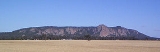
Most of the Wimmera is very flat, with only the Grampians and Mount Arapiles
rising above vast plains and the low plateau
x that form the Great Divide
in this part of Victoria. The Grampians are very rugged and tilted, with many sheer sandstone cliffs on their eastern sides, but gentle slopes on the west.
At the 2006 census
, the Wimmera statistical division had a population of 48,443.
, Warracknabeal
, Dimboola
, Stawell
and Nhill
. Almost all of these are largely dependent on the grain
and sheep industries, and are usually dominated by flour mills and grain storage silo
s. The smaller towns in the area are dying due to the constantly declining value of the primary products that dominate the region's economy
: modern farm technology allows individual farmers to stay viable by farming more land, but the lower population and better transport make smaller service centres less and less viable.
that dumped 133.2 millimetres on Nhill in mid-January 1974.
Temperatures are hot in summer, ranging typically from a maximum of 30°C (86°F) to a minimum of 14°C (57°F), whilst extremes can be as high as 44°C (111°F). In the winter, maximums are 15°C (59°F), but mornings can be cold, averaging at Horsham only 4°C (40°F).
and Warracknabeal there are heavy grey Vertisols, that, although still deficient in phosphorus
, are otherwise free of major nutrient deficiencies and are able to hold water very well. These grey soils are the principle wheat
soils of Victoria. Red-brown earths are also used for wheat but do not give as high yields and require more fertilisation.
flows from the Grampians towards Lake Hindmarsh
. Many streams in the region flow only after sustained heavy rainfall and are often dry for long spells. In fact, in recent years Rocklands Reservoir, the main water storage of the district, has become almost unviable due to a succession of dry years.
, which possesses many unusual wildflowers and the greatest diversity of flora and fauna in Victoria west of the Snowy River
. The Grampians also possess many important Aboriginal artifacts. A local aboriginal name Gariwerd was adopted by the National Park in 1991 in recognition of this fact, however this change was soon reversed after a change of state government in 1992.
, south of Nhill and west of Dimboola, is a large wilderness area of sand dunes that were too infertile for productive farming even with superphosphate and trace elements.
Australia
Australia , officially the Commonwealth of Australia, is a country in the Southern Hemisphere comprising the mainland of the Australian continent, the island of Tasmania, and numerous smaller islands in the Indian and Pacific Oceans. It is the world's sixth-largest country by total area...
n state of Victoria
Victoria (Australia)
Victoria is the second most populous state in Australia. Geographically the smallest mainland state, Victoria is bordered by New South Wales, South Australia, and Tasmania on Boundary Islet to the north, west and south respectively....
.
It covers the dryland farming area south of the range of Mallee
Division of Mallee
The Division of Mallee is an Australian Electoral Division in the state of Victoria. It is located in the far north-west of the state, adjoining the border with South Australia in the west, and the Murray River in the north. At , it is the largest Division in Victoria...
scrub, east of the South Australia
South Australia
South Australia is a state of Australia in the southern central part of the country. It covers some of the most arid parts of the continent; with a total land area of , it is the fourth largest of Australia's six states and two territories.South Australia shares borders with all of the mainland...
border and north of the Great Dividing Range
Great Dividing Range
The Great Dividing Range, or the Eastern Highlands, is Australia's most substantial mountain range and the third longest in the world. The range stretches more than 3,500 km from Dauan Island off the northeastern tip of Queensland, running the entire length of the eastern coastline through...
. It can also be defined as the land within the social catchment of Horsham
Horsham, Victoria
Horsham is the largest city by population and regional centre of the Wimmera region of Victoria, Australia and is approximately north-west of Melbourne via the Western Highway. At the 2006 census, Horsham had a population of 14,125. Horsham is in the federal Division of Mallee...
, its main settlement.
Most of the Wimmera is very flat, with only the Grampians and Mount Arapiles
Mount Arapiles
Mount Arapiles is a rock formation that rises 369 metres above the Wimmera plains in western Victoria, Australia. It is approximately 10 km from Natimuk, Victoria and is part of the Mount Arapiles-Tooan State Park. Arapiles is a very popular destination for rock climbers due to the quantity...
rising above vast plains and the low plateau
Plateau
In geology and earth science, a plateau , also called a high plain or tableland, is an area of highland, usually consisting of relatively flat terrain. A highly eroded plateau is called a dissected plateau...
x that form the Great Divide
Great Dividing Range
The Great Dividing Range, or the Eastern Highlands, is Australia's most substantial mountain range and the third longest in the world. The range stretches more than 3,500 km from Dauan Island off the northeastern tip of Queensland, running the entire length of the eastern coastline through...
in this part of Victoria. The Grampians are very rugged and tilted, with many sheer sandstone cliffs on their eastern sides, but gentle slopes on the west.
At the 2006 census
Census in Australia
The Australian census is administered once every five years by the Australian Bureau of Statistics. The most recent census was conducted on 9 August 2011; the next will be conducted in 2016. Prior to the introduction of regular censuses in 1961, they had also been run in 1901, 1911, 1921, 1933,...
, the Wimmera statistical division had a population of 48,443.
Towns
The area contains a number of important towns, such as HorshamHorsham, Victoria
Horsham is the largest city by population and regional centre of the Wimmera region of Victoria, Australia and is approximately north-west of Melbourne via the Western Highway. At the 2006 census, Horsham had a population of 14,125. Horsham is in the federal Division of Mallee...
, Warracknabeal
Warracknabeal, Victoria
Warracknabeal is a wheatbelt town in the Australian state of Victoria. Situated on the banks of the Yarriambiack Creek, 330 km north-west of Melbourne, it is the business and services centre of the northern Wimmera and southern Mallee districts, and hosts local government offices of the Shire...
, Dimboola
Dimboola, Victoria
Dimboola is located in Shire of Hindmarsh in the Wimmera region of Western Victoria, Australia, 334 kilometres north-west of Melbourne.Situated on the Wimmera River in the State of Victoria,the town of Dimboola was previously known as 'Nine Creeks'.Following a survey conducted in late 1862 by...
, Stawell
Stawell, Victoria
Stawell , is a town in the Wimmera region of Victoria, Australia. The town is located in Shire of Northern Grampians Local Government Area, west-north-west of the state capital, Melbourne. At the 2006 census, Stawell had a population of 6,035....
and Nhill
Nhill, Victoria
Nhill is a town in the Wimmera, in western Victoria, Australia. Nhill is located on the Western Highway, half-way between Adelaide and Melbourne. At the 2006 census Nhill had a population of 1915.-History:...
. Almost all of these are largely dependent on the grain
GRAIN
GRAIN is a small international non-profit organisation that works to support small farmers and social movements in their struggles for community-controlled and biodiversity-based food systems. Our support takes the form of independent research and analysis, networking at local, regional and...
and sheep industries, and are usually dominated by flour mills and grain storage silo
Storage silo
A silo is a structure for storing bulk materials. Silos are used in agriculture to store grain or fermented feed known as silage. Silos are more commonly used for bulk storage of grain, coal, cement, carbon black, woodchips, food products and sawdust. Three types of silos are in widespread use...
s. The smaller towns in the area are dying due to the constantly declining value of the primary products that dominate the region's economy
Economy
An economy consists of the economic system of a country or other area; the labor, capital and land resources; and the manufacturing, trade, distribution, and consumption of goods and services of that area...
: modern farm technology allows individual farmers to stay viable by farming more land, but the lower population and better transport make smaller service centres less and less viable.
Climate
The climate is semi-arid to sub-humid, with annual rainfall ranging generally from 380 millimetres (15 inches) in the north to 580 millimetres (23 inches) in the south. In the Grampians, annual precipitation can be as high as 1150 millimetres (46 inches) and snowfalls are not uncommon. Most rain falls in winter, though heavy summer falls can occur, the most famous of which was the thunderstormThunderstorm
A thunderstorm, also known as an electrical storm, a lightning storm, thundershower or simply a storm is a form of weather characterized by the presence of lightning and its acoustic effect on the Earth's atmosphere known as thunder. The meteorologically assigned cloud type associated with the...
that dumped 133.2 millimetres on Nhill in mid-January 1974.
Temperatures are hot in summer, ranging typically from a maximum of 30°C (86°F) to a minimum of 14°C (57°F), whilst extremes can be as high as 44°C (111°F). In the winter, maximums are 15°C (59°F), but mornings can be cold, averaging at Horsham only 4°C (40°F).
Soils
Most of the soils are very infertile and many are sandy; however in a narrow belt between NhillNhill, Victoria
Nhill is a town in the Wimmera, in western Victoria, Australia. Nhill is located on the Western Highway, half-way between Adelaide and Melbourne. At the 2006 census Nhill had a population of 1915.-History:...
and Warracknabeal there are heavy grey Vertisols, that, although still deficient in phosphorus
Phosphorus
Phosphorus is the chemical element that has the symbol P and atomic number 15. A multivalent nonmetal of the nitrogen group, phosphorus as a mineral is almost always present in its maximally oxidized state, as inorganic phosphate rocks...
, are otherwise free of major nutrient deficiencies and are able to hold water very well. These grey soils are the principle wheat
Wheat
Wheat is a cereal grain, originally from the Levant region of the Near East, but now cultivated worldwide. In 2007 world production of wheat was 607 million tons, making it the third most-produced cereal after maize and rice...
soils of Victoria. Red-brown earths are also used for wheat but do not give as high yields and require more fertilisation.
Rivers
The Wimmera RiverWimmera River
The Wimmera River is a river in Western Victoria, Australia. It begins in the Pyrenees, and flows into Lake Hindmarsh and Lake Albacutya, although in many years flows do not reach these terminal lakes and the river contracts to a series of pools of varying sizes...
flows from the Grampians towards Lake Hindmarsh
Lake Hindmarsh
Lake Hindmarsh in western Victoria is the state’s largest natural freshwater lake. The nearest towns are Jeparit to the south and Rainbow to the north.The lake has filled after more than a decade of drought, due to floods in early 2011.-History:...
. Many streams in the region flow only after sustained heavy rainfall and are often dry for long spells. In fact, in recent years Rocklands Reservoir, the main water storage of the district, has become almost unviable due to a succession of dry years.
The Grampians
One of the key preservation areas is contained within the Grampians National ParkGrampians National Park
The Grampians National Park is a national park in Victoria, Australia, 235 kilometres west of Melbourne. The Park was listed on the Australian National Heritage List on 15 December 2006 for its outstanding natural beauty and being one of the richest indigenous rock art sites in south-eastern...
, which possesses many unusual wildflowers and the greatest diversity of flora and fauna in Victoria west of the Snowy River
Snowy River
The Snowy River is a major river in south-eastern Australia. It originates on the slopes of Mount Kosciuszko, Australia's highest mainland peak, draining the eastern slopes of the Snowy Mountains in New South Wales, before flowing through the Snowy River National Park in Victoria and emptying into...
. The Grampians also possess many important Aboriginal artifacts. A local aboriginal name Gariwerd was adopted by the National Park in 1991 in recognition of this fact, however this change was soon reversed after a change of state government in 1992.
Little Desert
The (misnamed) Little Desert National ParkLittle Desert National Park
The Little Desert National Park is in Victoria, Australia, 375 kilometres west of Melbourne. It extends from the Wimmera River in the east to near Naracoorte over the South Australian border in the west.-History:...
, south of Nhill and west of Dimboola, is a large wilderness area of sand dunes that were too infertile for productive farming even with superphosphate and trace elements.