

Control point (orienteering)
Encyclopedia
A control point is a marked waypoint
Waypoint
A waypoint is a reference point in physical space used for purposes of navigation.-Concept:Waypoints are sets of coordinates that identify a point in physical space. Coordinates used can vary depending on the application. For terrestrial navigation these coordinates can include longitude and...
used in orienteering
Orienteering
Orienteering is a family of sports that requires navigational skills using a map and compass to navigate from point to point in diverse and usually unfamiliar terrain, and normally moving at speed. Participants are given a topographical map, usually a specially prepared orienteering map, which they...
and related sports such as rogaining
Rogaining
Rogaining is a sport of long distance cross-country navigation, involving both route planning and navigation between checkpoints using a variety of map types. In a rogaine, teams of 2-5 people choose which checkpoints to visit within a time limit with the intent of maximizing their score...
and adventure racing
Adventure racing
Adventure racing is a combination of two or more endurance disciplines, including orienteering and/or navigation , cross-country running, mountain biking, paddling and climbing and related rope skills...
. It is located in the competition area; marked both on an orienteering map
Orienteering map
An orienteering map is a map specially prepared for use in orienteering competitions. It is a topographic map with extra details to help the competitor navigate through the competition area....
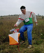
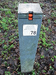
and in the terrain; and described on a control description sheet. The control point must be identifiable on the map and on the ground. A control point has three components: a high visibility item, known as a flag or kite; an identifier, known as a control code; and a recording mechanism for contestants to record proof that they visited the control point. The control point is usually temporary, except on a permanent orienteering course.
For events held under IOF Rules the kite has a triangular form with each face being about 30 cm x 30 cm and coloured white and orange. Most national governing bodies, and related sports, use the same design. The earlier specification used white and red.
The location of control points is kept secret from the competitors until the start of the competition, when they receive the map. The map may be pre-printed with the control points, or the competitor may be required to copy control points onto the map from a master map. Control points are selected and prepared anew for each competition. Permanent courses, with their permanent control points, are used primarily for training and recreation, but rarely for competition.
History
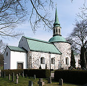
The first public orienteering competition, in Norway in 1897, had three controls, at the farms Finnerud, Bjørnholt and Slakteren, while start and finish were on the farm Grøttum (see map in ref). The first Swedish public orienteering competition, near Stockholm in 1901, used two churches (Bromma
Bromma Church
Bromma kyrka is a so-called round church in the borough Bromma in Stockholm, Sweden. The oldest parts of the church were built in the later 12th century as a fortress church, and the church is among Stockholm's oldest buildings....
and Spånga Church
Spånga Church
Spånga kyrka is a church in the Spånga-Tensta borough in Stockholm, Sweden. The oldest part of the church origins from the time period 1175 – 1200. Large reconstructions and enhancements took place during the 14th century and the 15th century....
) and two large farms as control points.
Control description sheet
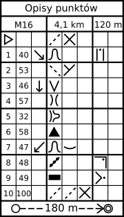

A popular software program for producing control description sheets is Clue, available free from the Delaware Valley Orienteering Association
Delaware Valley Orienteering Association
Delaware Valley Orienteering Association is the oldest and largest orienteering club in the United States. Caroline and Kent Ringo and others provided leadership from the late 1960s into the 2000s. DVOA distributes the popular Clue computer program for making control description sheets.DVOA held...
.
Control card and punching
Each competitor is required to carry a control card, and to present it at the Start and hand it in at the Finish. The control card is markedMarking
Marking may refer to:* An annotation* A perforation* Road surface marking, such as lines or words, or the stripes of a zebra crossing on a road surface* Card marking* Direct part marking * Exam markingPhotographic film markings* Postal marking...
by some means at each control point to show that the competitor has completed the course correctly.
In both trail orienteering
Trail Orienteering
Trail orienteering is an orienteering sport that involves precise reading of an orienteering map and the corresponding terrain. Trail orienteers must identify, in the terrain and in the presence of decoys, control points shown on the map...
and North America
North America
North America is a continent wholly within the Northern Hemisphere and almost wholly within the Western Hemisphere. It is also considered a northern subcontinent of the Americas...
n style mounted orienteering
Mounted orienteering
Mounted orienteering is the practice of orienteering while riding a horse or other riding animal.-History:Mounted orienteering was an important function of cavalry units and today remains an important skill for mounted search and rescue.-Competitive sport:...
, it may not be feasible, safe, or permitted for the competitor to go to the control point itself. Instead, the competitor views the control point from a short distance and marks the control card with a pen. Several marking schemes are in use, including a pre-printed multiple choice form, and a "secret word" posted at the control point that the competitor must copy down.
In foot orienteering, the oldest form of orienteering, the first control cards were card stock
Card stock
Card stock, also called cover stock or pasteboard, is a paper stock that is thicker and more durable than normal writing or printing paper, but thinner and more flexible than other forms of paperboard. Card stock is often used for business cards, postcards, playing cards, catalog covers,...
with a perforated stub
Ticket (admission)
A ticket is a voucher that indicates that one has paid for admission to an event or establishment such as a theatre, movie theater, amusement park, zoo, museum, concert, or other attraction, or permission to travel on a vehicle such as an airliner, train, bus, or boat, typically because one has...
, the stub to be handed in at the Start as a safety check. At each control, originally, the control staff or the competitor rubber stamp
Rubber stamp
Rubber stamping, also called stamping, is a craft in which some type of ink made of dye or pigment is applied to an image or pattern that has been carved, molded, laser engraved or vulcanized, onto a sheet of rubber. The rubber is often mounted onto a more stable object such as a wood, brick or an...
ed the control card using a rubber stamp and inkpad kept at that control. Rubber stamps soon were replaced with ticket punch
Ticket punch
A ticket punch is a hand tool for permanently marking admission tickets and similar items of paper or card stock. It makes a perforation and a corresponding chad. A ticket punch resembles a hole punch, differing in that the ticket punch has a longer jaw and the option of having a distinctive...
es, usually with a different punch shape (circular, square, diamond, star, etc.) at each control. Card stock control cards are in limited use today, having been mostly replaced by weatherproof stock such as Tyvek
Tyvek
Tyvek is a brand of flashspun high-density polyethylene fibers, a synthetic material; the name is a registered trademark of DuPont. The material is very strong; it is difficult to tear but can easily be cut with scissors or a knife...
. Ticket punches have been replaced by needle punches that punch a pattern of small holes in the control card (similar to a perfin
Perfin
In philately, a perfin is a stamp that has had initials or a name perforated across it to discourage theft. The name is a contraction of perforated initials or perforated insignia...
).
Weatherproof stock and needle punches are being replaced with electronic punch systems. The orienteer carries a small electronic control card that is a memory card encased in plastic and provided with a strap to attach to the finger. At each control point, and at the Start and Finish too, the orienteer inserts the card into a battery-operated station. There are two principal types of these, SPORTIdent and EMIT. The SPORTIdent control card is a small plastic stick ("e-card" or "e-punch', also "dibber" and "fingerstick"). The EMIT control card is a larger, card-shaped stick with a built-in backup feature: a small paper card inside the control card is pierced by a pin in a specific location at each station.
In both electronic punch systems, the control code (number) and punch time at each control point are recorded on the card. At the finish, data on the card are copied to a computer and a receipt is printed to confirm or deny that the course has been completed correctly. A system has been developed to report these data by amateur radio
Amateur radio
Amateur radio is the use of designated radio frequency spectrum for purposes of private recreation, non-commercial exchange of messages, wireless experimentation, self-training, and emergency communication...
. When a control card is punched, the reporting transmitter sends its own identifier and the orienteer's identifier and punch time. This is received at a base station, often located at the Finish, where the orienteer's progress on the course can be monitored and displayed to spectators.
Exceptions
Notable exceptions to the above control point features occur in several orienteering sports.- In amateur radio direction findingAmateur Radio Direction FindingAmateur radio direction finding is an amateur racing sport that combines radio direction finding with the map and compass skills of orienteering...
, the competitor uses a hand-held receiver to locate radio beacons at up to five control points that are not marked on the map. The Start, Finish, and optional drinking water stations are marked. - In trail orienteeringTrail OrienteeringTrail orienteering is an orienteering sport that involves precise reading of an orienteering map and the corresponding terrain. Trail orienteers must identify, in the terrain and in the presence of decoys, control points shown on the map...
, the control point is marked on the map and up to five control kites are placed in that vicinity. The kites do not have a control code. From an observation point the competitor records which is the correct kite. In elite competitions, "none" is a valid answer. - In NACMO (North American) style mounted orienteeringMounted orienteeringMounted orienteering is the practice of orienteering while riding a horse or other riding animal.-History:Mounted orienteering was an important function of cavalry units and today remains an important skill for mounted search and rescue.-Competitive sport:...
and fox OringFox OringFox Oring is a variation of the sport of Amateur Radio Direction Finding. Fox Oring is a timed race in which individual competitors use a topographic map and a magnetic compass to navigate through diverse, wooded terrain while searching for radio transmitters...
only the general vicinity of the control point is marked on the map. In both sports the first objective is to navigate to the vicinity of the control point. Once there, the subsequent objectives are to find clues and take bearings, triangulateTriangulationIn trigonometry and geometry, triangulation is the process of determining the location of a point by measuring angles to it from known points at either end of a fixed baseline, rather than measuring distances to the point directly...
the location of the control point, then go directly to the control point. In mounted orienteering, once in the vicinity the competitor searches for clues (called landmarks) on a description sheet. The description sheet gives bearings from each clue to the control point. In fox Oring, once in the vicinity the competitor searches for a low power beacon at the control point. - In TREC (European) style mounted orienteeringMounted orienteeringMounted orienteering is the practice of orienteering while riding a horse or other riding animal.-History:Mounted orienteering was an important function of cavalry units and today remains an important skill for mounted search and rescue.-Competitive sport:...
, which permits no route choiceRoute choice (orienteering)Route choice is a tactic in orienteering and related sports such as rogaining and adventure racing. These sports involve navigation from one control point to the next and, in most cases, the choice of route is left to the competitor. This is provided the rules permit route choice and the course...
, there are no control points for competitors but officials observe the competitors at specific points on the prescribed course.