

Congress Heights
Encyclopedia
Washington, D.C. (southeast)
Southeast is the southeastern quadrant of Washington, D.C., the capital of the United States, and is located south of East Capitol Street and east of South Capitol Street. It includes the Capitol Hill and Anacostia neighborhoods, the Navy Yard, the Marine Barracks, the Anacostia River waterfront,...
Washington, D.C.
Washington, D.C.
Washington, D.C., formally the District of Columbia and commonly referred to as Washington, "the District", or simply D.C., is the capital of the United States. On July 16, 1790, the United States Congress approved the creation of a permanent national capital as permitted by the U.S. Constitution....
Although it is in the poorest section of what is generally regarded as inner-city Washington—the area east of the Anacostia River
Anacostia River
The Anacostia River is a river in the Mid Atlantic region of the United States. It flows from Prince George's County in Maryland into Washington, D.C., where it joins with the Washington Channel to empty into the Potomac River at Buzzard Point. It is approximately long...
-- it is very likely the most economically diverse, and most suburban, neighborhood in that section of the city. Congress Heights, in fact, contains the largest commercial district in Washington's Ward 8, along Martin Luther King Jr. and Malcolm X
Malcolm X
Malcolm X , born Malcolm Little and also known as El-Hajj Malik El-Shabazz , was an African American Muslim minister and human rights activist. To his admirers he was a courageous advocate for the rights of African Americans, a man who indicted white America in the harshest terms for its...
Avenues.
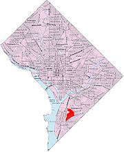
Congress Heights is bounded by Mississippi Avenue SE to the southeast, Wheeler Road SE to the east, Alabama Avenue SE to the north, and Martin Luther King Jr. Avenue and South Capitol Street to the northwest. It is served by the Congress Heights
Congress Heights (Washington Metro)
Congress Heights is an island platformed Washington Metro station in the Congress Heights neighborhood of Washington, D.C., United States. The station was opened on January 13, 2001, and is operated by the Washington Metropolitan Area Transit Authority . Providing service for only the Green Line,...
station on the Green Line
Green Line (Washington Metro)
The Green Line is one of five heavy rail subway lines that constitute the Washington Metro rapid transit system in the Washington, D.C., metropolitan area. The Green Line consists of 21 stations, with termini at Branch Avenue and at Greenbelt. The Green Line runs through Prince George's County,...
of the Washington Metro
Washington Metro
The Washington Metro, commonly called Metro, and unofficially Metrorail, is the rapid transit system in Washington, D.C., United States, and its surrounding suburbs. It is administered by the Washington Metropolitan Area Transit Authority , which also operates Metrobus service under the Metro name...
. Most residents live in garden apartments, but there are also older single-family bungalows. Frank W. Ballou High School and Hart Middle School serve the neighborhood.
Congress Heights, which takes its name from its hilly geography that offers a view across the Anacostia
Anacostia
Anacostia is a historic neighborhood in Washington, D.C. Its historic downtown is located at the intersection of Good Hope Road and Martin Luther King, Jr. Avenue It is the most famous neighborhood in the Southeast quadrant of Washington, located east of the Anacostia River, after which the...
to the Capitol
United States Capitol
The United States Capitol is the meeting place of the United States Congress, the legislature of the federal government of the United States. Located in Washington, D.C., it sits atop Capitol Hill at the eastern end of the National Mall...
, began development as a neighborhood in the late 1920s when it was established as the end of the Washington streetcars
Washington streetcars
For just under 100 years, between 1862 and 1962, streetcars in Washington, D.C. transported people across the city and region.The first streetcars in Washington D.C...
line. Prior to World War II
World War II
World War II, or the Second World War , was a global conflict lasting from 1939 to 1945, involving most of the world's nations—including all of the great powers—eventually forming two opposing military alliances: the Allies and the Axis...
the D.C. National Guard was housed at Camp Simms. The facility included firing ranges up to 1,000 yards. It was on Alabama Avenue at the intersection of Stanton Road and Barry Farms Housing Project. During WW II it had gun emplacements (Anti-Aircraft) to defend Washington from air attack. After World War II, the U.S. Army built a military reserve facility, in the central part of Congress Heights. The campus of St. Elizabeths Hospital
St. Elizabeths Hospital
St. Elizabeths Hospital is a psychiatric hospital operated by the District of Columbia Department of Mental Health. It was the first large-scale, federally-run psychiatric hospital in the United States. Housing several thousand patients at its peak, St. Elizabeths had a fully functioning...
already stood immediately northwest of the neighborhood. Many early residents worked at the U.S. Naval Gun Factory, which stopped production about 1960, or at the U.S. Naval Research Laboratory. The annual Martin Luther King Birthday parade on the avenue bearing his name, is a notable neighborhood event. Starting in 2006, the parade date was changed from January to April to accommodate for cold weather. Now, the parade is held closer to the anniversary of his death (April 4, 1968), rather than his birthday (January 15, 1929). There is a new tennis and learning center on Mississippi Avenue, combining sports and school tutoring.
Because of its location in Southeast Washington, Congress Heights had experienced great urban neglect for several decades.The reason it experienced neglect was due to the great white flight as it was termed by journalists in the middle sixties. However, in the 21st century, Congress Heights has received a great deal of attention from the city and urban developers. Nineteen development projects worth a total of $455 million are underway or completed in Congress Heights as of November 2006. Among these are a redevelopment of St. Elizabeths West Campus for federal use; a request for proposals from the Washington Metropolitan Area Transit Authority
Washington Metropolitan Area Transit Authority
The Washington Metropolitan Area Transit Authority is a tri-jurisdictional government agency that operates transit service in the Washington, D.C. metropolitan area, including the Metrorail, Metrobus and MetroAccess...
for the area around the Congress Heights Metro station; and a planned redevelopment of Camp Simms as a mixed-use project, including a new Giant Grocery Store, enhancement to an existing shopping center, and 75 new residential units. http://www.wdcep.com/pdf/neighborhoods/congresshts.pdf