

Washington, D.C. (southeast)
Encyclopedia
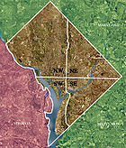
Quadrants of Washington, D.C.
Washington, D.C., is administratively divided into four geographical quadrants of unequal size, each delineated by their ordinal directions from the medallion located in the Crypt under the Rotunda of the Capitol...
, the capital of the United States
United States
The United States of America is a federal constitutional republic comprising fifty states and a federal district...
, and is located south of East Capitol Street
East Capitol Street
East Capitol Street is a major street that divides the northeast and southeast quadrants of Washington, D.C. It runs due east from the United States Capitol to the DC-Maryland border. The street is uninterrupted until Lincoln Park then continues eastward to Robert F. Kennedy Memorial Stadium...
and east of South Capitol Street
South Capitol Street
South Capitol Street is a major street dividing the southeast and southwest quadrants of Washington, D.C. It runs south from the United States Capitol to the Washington-Maryland line...
. It includes the Capitol Hill and Anacostia
Anacostia
Anacostia is a historic neighborhood in Washington, D.C. Its historic downtown is located at the intersection of Good Hope Road and Martin Luther King, Jr. Avenue It is the most famous neighborhood in the Southeast quadrant of Washington, located east of the Anacostia River, after which the...
neighborhoods, the Navy Yard, the Marine Barracks
Marine Barracks, Washington, D.C.
Marine Barracks, Washington, D.C. is located at 8th and I Streets, Southeast in Washington, D.C. Established in 1801, it is a National Historic Landmark, the oldest post in the United States Marine Corps, the official residence of the Commandant of the Marine Corps since 1806, and main ceremonial...
, the Anacostia River
Anacostia River
The Anacostia River is a river in the Mid Atlantic region of the United States. It flows from Prince George's County in Maryland into Washington, D.C., where it joins with the Washington Channel to empty into the Potomac River at Buzzard Point. It is approximately long...
waterfront, Eastern Market
Eastern Market, Washington, D.C.
The Eastern Market is a public market in the Capitol Hill neighborhood of Washington, D.C., housed in a 19th century brick building. It is located on 7th Street SE, a few blocks east of the U.S. Capitol between North Carolina Avenue SE and C Street SE. The Eastern Market is on the National...
, the remains of several Civil War
American Civil War
The American Civil War was a civil war fought in the United States of America. In response to the election of Abraham Lincoln as President of the United States, 11 southern slave states declared their secession from the United States and formed the Confederate States of America ; the other 25...
-era forts, historic St. Elizabeths Hospital
St. Elizabeths Hospital
St. Elizabeths Hospital is a psychiatric hospital operated by the District of Columbia Department of Mental Health. It was the first large-scale, federally-run psychiatric hospital in the United States. Housing several thousand patients at its peak, St. Elizabeths had a fully functioning...
, RFK Stadium
Robert F. Kennedy Memorial Stadium
Robert F. Kennedy Memorial Stadium is a multi-purpose stadium, in Washington, D.C., United States, and the current home of MLS's D.C. United....
, Nationals Park, and the Congressional Cemetery
Congressional Cemetery
The Congressional Cemetery is a historic cemetery located at 1801 E Street, SE, in Washington, D.C., on the west bank of the Anacostia River. It is the final resting place of thousands of individuals who helped form the nation and the city of Washington in the early 19th century. Many members of...
. It is also home to a landmark known as "The Big Chair," located on Martin Luther King Avenue. The quadrant is bisected by the Anacostia River
Anacostia River
The Anacostia River is a river in the Mid Atlantic region of the United States. It flows from Prince George's County in Maryland into Washington, D.C., where it joins with the Washington Channel to empty into the Potomac River at Buzzard Point. It is approximately long...
, with the portion that is west of the river sometimes referred to as "Near Southeast".
The population of Southeast is predominantly African-American, particularly east of the Anacostia River
Anacostia River
The Anacostia River is a river in the Mid Atlantic region of the United States. It flows from Prince George's County in Maryland into Washington, D.C., where it joins with the Washington Channel to empty into the Potomac River at Buzzard Point. It is approximately long...
. Despite overall high crime rates for the quadrant, there are Black middle class
Black middle class
The black middle class, within the United States, refers to African Americans who occupy a middle class status within the American class structure. It is predominately a development that arose after the 1960s, during which the African American Civil Rights Movement led to reform movements aimed at...
neighborhoods, such as Hillcrest
Hillcrest, Washington, D.C.
Hillcrest is a neighborhood in the southeast quadrant of Washington, D.C., United States. Hillcrest is located in Ward 7, east of the Anacostia River. Hillcrest is a rather affluent and well-kept neighborhood. Former mayor Marion Barry is a former resident. Current residents include Mayor Vincent C...
, Penn Branch
Penn Branch
Penn Branch is a neighborhood in Southeast Washington, D.C., east of the Anacostia River. It is bounded by Pennsylvania Avenue SE to the south; Pope Branch Park and Pope Creek to the north; Branch Avenue to the west; and Fort Davis Park to the east...
, and Fort Dupont
Fort Dupont
Fort Dupont is a residential neighborhood located in southeast Washington, D.C, east of the Anacostia River. It is bounded by East Capitol Street to the north, Fort Dupont Park to the south, Minnesota Avenue to the west, and Fort Chaplin Park to the east and northeast.Fort Dupont is adjacent to...
. Throughout the Southeast area (except for the gentrified Eastern Market area closest to the United States Capitol), basic shopping, dining, entertainment, and cultural facilities are very minimal and scanty, so that residents must travel either downtown or to the suburbs for such services. Cultural events/activities include the annual Martin Luther King Birthday parade, the free weekly summer jazz concerts in Fort Dupont
Fort Dupont
Fort Dupont is a residential neighborhood located in southeast Washington, D.C, east of the Anacostia River. It is bounded by East Capitol Street to the north, Fort Dupont Park to the south, Minnesota Avenue to the west, and Fort Chaplin Park to the east and northeast.Fort Dupont is adjacent to...
Park, the Fort Dupont ice-rink, the Anacostia Museum
Anacostia Museum
The Anacostia Community Museum is a Smithsonian Institution museum in the Anacostia neighborhood of Washington, D.C., United States, opened in 1967...
of the Smithsonian Institution
Smithsonian Institution
The Smithsonian Institution is an educational and research institute and associated museum complex, administered and funded by the government of the United States and by funds from its endowment, contributions, and profits from its retail operations, concessions, licensing activities, and magazines...
, and the tennis and learning center for youth on Mississippi Avenue. The population of the southeast quadrant is roughly 134,800 and is about 97% African American.
Politically, Southeast includes most of Ward 8, as well as much of Wards 6 and 7. Ward 8 is home to former mayor and current DC Council Member Marion Barry
Marion Barry
Marion Shepilov Barry, Jr. is an American Democratic politician who is currently serving as a member of the Council of the District of Columbia, representing DC's Ward 8. Barry served as the second elected mayor of the District of Columbia from 1979 to 1991, and again as the fourth mayor from 1995...
.
The quadrant is known to many D.C. area residents as being plagued by a consistently high crime rate relative to the rest of the city. Public transit facilities are frequently targeted for vandalism. The Washington Post
The Washington Post
The Washington Post is Washington, D.C.'s largest newspaper and its oldest still-existing paper, founded in 1877. Located in the capital of the United States, The Post has a particular emphasis on national politics. D.C., Maryland, and Virginia editions are printed for daily circulation...
reported in 2003 that rock attacks on public buses were so common that bus drivers were instructed to wear safety goggles while traversing the quadrant.
Nationals Park, the new home of Major League Baseball
Major League Baseball
Major League Baseball is the highest level of professional baseball in the United States and Canada, consisting of teams that play in the National League and the American League...
's Washington Nationals
Washington Nationals
The Washington Nationals are a professional baseball team based in Washington, D.C. The Nationals are a member of the Eastern Division of the National League of Major League Baseball . The team moved into the newly built Nationals Park in 2008, after playing their first three seasons in RFK Stadium...
, opened in Southeast in March 2008. Southeast Washington is accessible via the Blue
Blue Line (Washington Metro)
The Blue Line of the Washington Metro in the United States consists of 27 rapid transit stations from Franconia–Springfield to Largo Town Center. It has stations in Fairfax County, Alexandria and Arlington, Virginia, the District of Columbia, and Prince George's County, Maryland...
, Orange
Orange Line (Washington Metro)
The Orange Line of the Washington Metro consists of 26 rapid transit stations from Vienna to New Carrollton. It has stations in Fairfax County and Arlington, Virginia, the District of Columbia, and Prince George's County, Maryland. Half of the line's stations are shared with the Blue Line, and over...
and Green Lines
Green Line (Washington Metro)
The Green Line is one of five heavy rail subway lines that constitute the Washington Metro rapid transit system in the Washington, D.C., metropolitan area. The Green Line consists of 21 stations, with termini at Branch Avenue and at Greenbelt. The Green Line runs through Prince George's County,...
of the Washington Metro
Washington Metro
The Washington Metro, commonly called Metro, and unofficially Metrorail, is the rapid transit system in Washington, D.C., United States, and its surrounding suburbs. It is administered by the Washington Metropolitan Area Transit Authority , which also operates Metrobus service under the Metro name...
. Southeast Washington will also be accessible via the Silver Line
Silver Line (Washington Metro)
The Dulles Corridor Metrorail Project, formally dubbed the Silver Line, is an extension of the Washington Metro rapid transit system, currently under construction with the goal of providing rapid transit service to Dulles International Airport and Tysons Corner...
when completed.