
Colton, New York
Encyclopedia
Town
A town is a human settlement larger than a village but smaller than a city. The size a settlement must be in order to be called a "town" varies considerably in different parts of the world, so that, for example, many American "small towns" seem to British people to be no more than villages, while...
in St. Lawrence County
St. Lawrence County, New York
St. Lawrence County is a county located in the U.S. state of New York. As of the 2010 census, the population was 111,944. The county seat is Canton. The county is named for the Saint Lawrence River, which in turn was named for the Catholic saint on whose Feast day the river was discovered by...
, New York
New York
New York is a state in the Northeastern region of the United States. It is the nation's third most populous state. New York is bordered by New Jersey and Pennsylvania to the south, and by Connecticut, Massachusetts and Vermont to the east...
, USA
United States
The United States of America is a federal constitutional republic comprising fifty states and a federal district...
. The population was 1,453 at the 2000 census. The town, originally named Matildaville, is named after early settler Jesse Colton Higley.
The Town of Colton is located in the southeast part of the county and is south of the Village of Potsdam
Potsdam (village), New York
Potsdam is a village located in the Town of Potsdam in St. Lawrence County, New York, USA. The population was 9,425 at the 2000 census.The Village of Potsdam is in the eastern part of the town and is northeast of Canton, the county seat....
.
History
The first land patents were issued in 1776. The first settlement occurred around 1825 near Colton village in the northern part of the town.Colton was organized in 1843 from part of the Town of Parishville
Parishville, New York
Parishville is a town in the east-central part of St. Lawrence County, east of Potsdam, in the state of New York, United States. The population was 2,049 at the 2000 census.- History :...
. Additional land from Parishville was added to Colton in 1851, and Colton was increased in 1876 from territory taken from the Town of Hopkinton
Hopkinton, New York
Hopkinton is a town in St. Lawrence County, New York in the United States. The population was 1,020 at the 2000 census. The name is derived from early settlers with the name Hopkins....
.
Geography
According to the United States Census BureauUnited States Census Bureau
The United States Census Bureau is the government agency that is responsible for the United States Census. It also gathers other national demographic and economic data...
, the town has a total area of 254.9 square miles (660.2 km²), of which, 242.1 square miles (627 km²) of it is land and 12.8 square miles (33.2 km²) of it (5.04%) is water.
Colton is the largest town in St. Lawrence County. St Lawrence county is the largest county in NY state. The south town line is the border of Hamilton County
Hamilton County, New York
Hamilton County is a county located in the U.S. state of New York. It is named after Alexander Hamilton, the only member of the New York State delegation who signed the United States Constitution in 1787 and later the first United States Secretary of the Treasury. Its county seat is Lake Pleasant...
and Herkimer County
Herkimer County, New York
Herkimer County is a county located in the U.S. state of New York. It was created in 1791 north of the Mohawk River out of part of Montgomery County. As of the 2010 census, the population was 64,519. It is named after General Nicholas Herkimer, who died from battle wounds in 1777 after taking part...
.
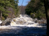
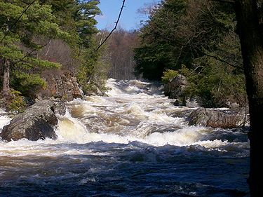
The Raquette River
Raquette River
The Raquette River, sometimes spelled Racquette, originates at Raquette Lake in the Adirondack Mountains in New York. long, it is the third longest river entirely in the state of New York....
flows through the west part of the town. The town is in the foothills of the Adirondack Mountains
Adirondack Mountains
The Adirondack Mountains are a mountain range located in the northeastern part of New York, that runs through Clinton, Essex, Franklin, Fulton, Hamilton, Herkimer, Lewis, Saint Lawrence, Saratoga, Warren, and Washington counties....
. Most of the town, the southern part, is inside the Adirondack Park.
New York State Route 56
New York State Route 56
New York State Route 56 is a north–south state highway in eastern St. Lawrence County, New York, United States. The southern terminus of the route is at an intersection with NY 3 in the town of Colton. Its northern terminus is at a junction with NY 37 southwest of Massena in the...
intersects New York State Route 68
New York State Route 68
New York State Route 68 is an east–west state highway located entirely within St. Lawrence County in the North Country of New York in the United States. The western terminus is at an intersection with NY 37 in Oswegatchie, just west of the Ogdensburg city limits...
at Colton village. New York State Route 3
New York State Route 3
New York State Route 3 is a major east–west state highway in New York, United States, that connects central New York to the North Country region near the Canadian border via Adirondack Park. The route extends for between its western terminus at an intersection with NY 104A in the Cayuga...
intersects NY-56 in the east-central part of the town at Sevey Corners.
Demographics
As of the censusCensus
A census is the procedure of systematically acquiring and recording information about the members of a given population. It is a regularly occurring and official count of a particular population. The term is used mostly in connection with national population and housing censuses; other common...
of 2000, there were 1,453 people, 604 households, and 405 families residing in the town. The population density
Population density
Population density is a measurement of population per unit area or unit volume. It is frequently applied to living organisms, and particularly to humans...
was 6.0 people per square mile (2.3/km²). There were 1,163 housing units at an average density of 4.8 per square mile (1.9/km²). The racial makeup of the town was 99.17% White, 0.34% Native American, 0.07% Asian, and 0.41% from two or more races. Hispanic or Latino of any race were 0.89% of the population.
There were 604 households out of which 25.2% had children under the age of 18 living with them, 55.6% were married couples
Marriage
Marriage is a social union or legal contract between people that creates kinship. It is an institution in which interpersonal relationships, usually intimate and sexual, are acknowledged in a variety of ways, depending on the culture or subculture in which it is found...
living together, 6.1% had a female householder with no husband present, and 32.8% were non-families. 26.0% of all households were made up of individuals and 10.3% had someone living alone who was 65 years of age or older. The average household size was 2.40 and the average family size was 2.90.
In the town the population was spread out with 22.6% under the age of 18, 6.3% from 18 to 24, 24.8% from 25 to 44, 30.0% from 45 to 64, and 16.2% who were 65 years of age or older. The median age was 42 years. For every 100 females there were 102.4 males. For every 100 females age 18 and over, there were 101.8 males.
The median income for a household in the town was $38,875, and the median income for a family was $44,637. Males had a median income of $35,000 versus $22,443 for females. The per capita income
Per capita income
Per capita income or income per person is a measure of mean income within an economic aggregate, such as a country or city. It is calculated by taking a measure of all sources of income in the aggregate and dividing it by the total population...
for the town was $20,528. About 10.5% of families and 14.7% of the population were below the poverty line, including 22.5% of those under age 18 and 6.5% of those age 65 or over.
Communities and locations in Colton
- Brandy Brook – A location in the southwest part of the town on NY-3.
- Carry Falls Reservoir – A reservoirReservoirA reservoir , artificial lake or dam is used to store water.Reservoirs may be created in river valleys by the construction of a dam or may be built by excavation in the ground or by conventional construction techniques such as brickwork or cast concrete.The term reservoir may also be used to...
in the northeast part of Colton. - Colton – The hamlet of Colton is located at the junction of NY-56 and NY-68 by the Raquette RiverRaquette RiverThe Raquette River, sometimes spelled Racquette, originates at Raquette Lake in the Adirondack Mountains in New York. long, it is the third longest river entirely in the state of New York....
. The community, in the northwest part of the town, is the location of the first settlement. - Cranberry LakeCranberry LakeCranberry Lake is a lake on the Oswegatchie River in the Adirondack Park in New York in the United States. It is the third largest lake in the Adirondack Park Cranberry Lake is a lake on the Oswegatchie River in the Adirondack Park in New York in the United States. It is the third largest lake in...
– A large lake near the southwest town line, but only a small part of the lake is in Colton. - Granshue Club – A location south of Stark near the west town line.
- Higley Flow State ParkHigley Flow State ParkHigley Flow State Park is located in the township of Colton in St. Lawrence County, New York in the USA. The park is located on Higley Flow, a body of water which is an impoundment of the Raquette River....
– A state parkState parkState parks are parks or other protected areas managed at the federated state level within those nations which use "state" as a political subdivision. State parks are typically established by a state to preserve a location on account of its natural beauty, historic interest, or recreational...
west of South Colton. - Irish Settlement – A hamlet near the town center on NY-56.
- Lows LakeLows LakeLows Lake is a reservoir in the Adirondack Park in northeastern New York. It is located in the Five Ponds Wilderness Area, southwest of Tupper Lake. The lake is part of the Bog River Flow. While it is largely surrounded by New York State Forest Preserve, the northeast shore is privately held,...
– A lakeLakeA lake is a body of relatively still fresh or salt water of considerable size, localized in a basin, that is surrounded by land. Lakes are inland and not part of the ocean and therefore are distinct from lagoons, and are larger and deeper than ponds. Lakes can be contrasted with rivers or streams,...
partly in the southwest corner of Colton. - Sevey – A hamlet in the central part of the town on NY-56
- Sevey Corners – A location in the east-central part of the town on NY-3, south of Sevey.
- Shurteff – A hamlet southwest of Sevey on NY-3.
- South Colton – A village in the north part of Colton, south of Colton village on NY-56.
- Stark – A hamlet by the town line in the eastern part of Colton.
- Stark Reservoir – A reservoir south of Stark and north of Carry Falls Reservoir.
- Stone Valley Recreational Area - A hiking and fishing area along the Raquette River, north of the hamlet of Colton.