

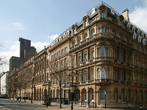
Colmore Row
Encyclopedia
Street
A street is a paved public thoroughfare in a built environment. It is a public parcel of land adjoining buildings in an urban context, on which people may freely assemble, interact, and move about. A street can be as simple as a level patch of dirt, but is more often paved with a hard, durable...
in the centre of Birmingham
Birmingham
Birmingham is a city and metropolitan borough in the West Midlands of England. It is the most populous British city outside the capital London, with a population of 1,036,900 , and lies at the heart of the West Midlands conurbation, the second most populous urban area in the United Kingdom with a...
, England
England
England is a country that is part of the United Kingdom. It shares land borders with Scotland to the north and Wales to the west; the Irish Sea is to the north west, the Celtic Sea to the south west, with the North Sea to the east and the English Channel to the south separating it from continental...
, running from Victoria Square
Victoria Square, Birmingham
Victoria Square is a pedestrianised public square in Birmingham, England. It is home to both the Town Hall and the Council House, and directly adjacent to Chamberlain Square....
to just beyond Snow Hill station
Birmingham Snow Hill station
Birmingham Snow Hill is a railway station and tram stop in the centre of Birmingham, England, on the site of an earlier, much larger station built by the former Great Western Railway . It is the second most important railway station in the city, after Birmingham New Street station...
. It is traditionally the city's most prestigious business address.
Colmore Row and its environs were designated a conservation area
Conservation area
A conservation areas is a tract of land that has been awarded protected status in order to ensure that natural features, cultural heritage or biota are safeguarded...
in 1971, which was extended twice in 1985. Colmore Row itself has 23 listed buildings, two listed at Grade I and two at Grade II*.
History
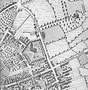
Dudley
Dudley is a large town in the West Midlands county of England. At the 2001 census , the Dudley Urban Sub Area had a population of 194,919, making it the 26th largest settlement in England, the second largest town in the United Kingdom behind Reading, and the largest settlement in the UK without...
and West Bromwich
West Bromwich
West Bromwich is a town within the Metropolitan Borough of Sandwell, in the West Midlands, England. It is north west of Birmingham lying on the A41 London-to-Birkenhead road. West Bromwich is part of the Black Country...
and separating the farmlands of the New Hall Estate to the north from those of the Inge Estate to the south. Development of the south of the lane started with the building of St Philip's Church (now St Philip's Cathedral
St Philip's Cathedral, Birmingham
The Cathedral Church of Saint Philip is the Church of England cathedral and the seat of the Bishop of Birmingham. Built as a parish church and consecrated in 1715, St Philip's became the cathedral of the newly formed Diocese of Birmingham in the West Midlands in 1905...
) in 1708. In 1746 a private Act of Parliament
Act of Parliament
An Act of Parliament is a statute enacted as primary legislation by a national or sub-national parliament. In the Republic of Ireland the term Act of the Oireachtas is used, and in the United States the term Act of Congress is used.In Commonwealth countries, the term is used both in a narrow...
opened up the New Hall Estate to the north for development, with the first plots being let and developed from 1747 onwards.
The road was renamed at this point, but initially only the stretch between Newhall Street
Newhall Street
Newhall Street is a street located in Birmingham, England.Newhall Street stretches from Colmore Row in the city centre by St Phillip's Cathedral in a north-westerly direction towards the Jewellery Quarter. Originally the road was the driveway to New Hall occupied by the Colmore family...
and Livery Street was named Colmore Row (after the Colmore family, owners of the New Hall Estate). The stretch between Newhall Street and New Street was named Ann Street, after head of the family Ann Colmore, while the stretch north of Livery Street, originally called Bull Lane, became known as Monmouth Street.
Ann Street disappeared as a name when the street was divided between Colmore Row and Victoria Square
Victoria Square, Birmingham
Victoria Square is a pedestrianised public square in Birmingham, England. It is home to both the Town Hall and the Council House, and directly adjacent to Chamberlain Square....
, when the latter was created (initially as Council House Square) in 1879.
The original buildings of Colmore Row were the brick and stucco Georgian
Georgian architecture
Georgian architecture is the name given in most English-speaking countries to the set of architectural styles current between 1720 and 1840. It is eponymous for the first four British monarchs of the House of Hanover—George I of Great Britain, George II of Great Britain, George III of the United...
houses typical of the late 18th century. The 120 year leases on these properties started to expire in the 1840s and 1850s, and between 1869 and 1900 all were replaced by the late Victorian
Victorian architecture
The term Victorian architecture refers collectively to several architectural styles employed predominantly during the middle and late 19th century. The period that it indicates may slightly overlap the actual reign, 20 June 1837 – 22 January 1901, of Queen Victoria. This represents the British and...
commercial premises that still give the street its predominant character.
Herbert Manzoni
Sir Herbert John Baptista Manzoni CBE MICE was a British civil engineer known for holding the position of City Engineer and Surveyor of Birmingham from 1935 until 1963...
. This would have necessitated demolishing all of the buildings between Colmore Row and Waterloo Street, but fell victim to increasing land values and awareness of conservation issues in the 1970s. The plans for the street included widening it to a width of 112 ft (34.1 m) with a central reservation of 14 ft (4.3 m) in width. Ironically, the likelihood of forthcoming comprehensive redevelopment protected many of the buildings from being demolished to make way for office developments (see Colmore Business District), and today Colmore Row and the surrounding area has one of the most consistent 19th century streetscapes in Central Birmingham.
In 1980s, Barclays Bank proposed a redevelopment of 55-73 Colmore Row. The scheme involved the demolition of the entire building except for the façades and the banking hall of the listed building. The local planning authority
Local Planning Authority
A local planning authority is the local authority or council that is empowered by law to exercise planning functions for a particular area of the United Kingdom. Although, in Scotland, where all of the local authorities are unitary, the term 'planning authority' is used without the 'local'...
called for greater retention of the building structure as with other schemes in the area. The agents submitted multiple planning applications to put pressure on the planning department. As the planning department failed to come to a decision on two planning applications in their time periods, the bank took the case to a government department. Barclays and local planning authority failed to reach any deal in negotiations, which eventually broke down. The government saw that the retention of the façade was satisfactory as it allowed the economic reuse of the site. The decision left the development and design framework for the area in a weakened state as the building subject to the decision was deemed to be of less national importance in respect to its local importance. The use of façadism on the building has since been seen as successful following the addition of Mansard roof
Mansard roof
A mansard or mansard roof is a four-sided gambrel-style hip roof characterized by two slopes on each of its sides with the lower slope at a steeper angle than the upper that is punctured by dormer windows. The roof creates an additional floor of habitable space, such as a garret...
s providing additional floorspace.
Transport Hub
In addition to Snow Hill railway stationBirmingham Snow Hill station
Birmingham Snow Hill is a railway station and tram stop in the centre of Birmingham, England, on the site of an earlier, much larger station built by the former Great Western Railway . It is the second most important railway station in the city, after Birmingham New Street station...
, and the current terminus of the Midland Metro
Midland Metro
The Midland Metro is a light-rail or tram line in the West Midlands of England between the cities of Birmingham and Wolverhampton via West Bromwich and Wednesbury. It is owned and promoted by Centro, and operated by West Midlands Travel Limited, a subsidiary of the National Express Group , under...
, Colmore Row also hosts the city centre bus stops AB to AF - which together have the IATA location identifier code ZBC.
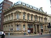
Notable buildings
- St Philip's CathedralSt Philip's Cathedral, BirminghamThe Cathedral Church of Saint Philip is the Church of England cathedral and the seat of the Bishop of Birmingham. Built as a parish church and consecrated in 1715, St Philip's became the cathedral of the newly formed Diocese of Birmingham in the West Midlands in 1905...
(Thomas ArcherThomas ArcherThomas Archer was an English Baroque architect, whose work is somewhat overshadowed by that of his contemporaries Sir John Vanbrugh and Nicholas Hawksmoor. Archer was born at Umberslade Hall in Tanworth-in-Arden in Warwickshire, the youngest son of Thomas Archer, a country gentleman, Parliamentary...
, 1725) - 122-124 Colmore Row122-124 Colmore Row122-124 Colmore Row, built as the Eagle Insurance Offices and now Hudson's Coffee House, is a Grade I listed building on Colmore Row in Birmingham, England....
, former Eagle Insurance Company offices (William LethabyWilliam LethabyWilliam Richard Lethaby was an English architect and architectural historian whose ideas were highly influential on the late Arts and Crafts and early Modern movements in architecture, and in the fields of conservation and art education.-Early life:Lethaby was born in Barnstaple, Devon, the son of...
and Joseph Ball, 1900) - Great Western ArcadeGreat Western ArcadeThe Great Western Arcade is a covered Grade II listed Victorian shopping arcade lying between Colmore Row and Temple Row in Birmingham 4, England....
(W. H. Ward, 1876) - 59-85 Colmore Row (mainly by Yeoville ThomasonYeoville ThomasonH. R. Yeoville Thomason was an architect in Birmingham, England. He was born in Edinburgh to a Birmingham family. Thomason set up his own practice in Birmingham 1853-1854....
) - National Westminster HouseNational Westminster House103 Colmore Row is a building on Colmore Row, Birmingham, England once owned by NatWest. It is now owned by the developer British Land who received planning permission in September 2008 to replace the tower with a office skyscraper.-Current building:The current building is a 23 storey structure...
(John Madin Design Group, 1974) - Snow Hill stationBirmingham Snow Hill stationBirmingham Snow Hill is a railway station and tram stop in the centre of Birmingham, England, on the site of an earlier, much larger station built by the former Great Western Railway . It is the second most important railway station in the city, after Birmingham New Street station...