

Collocation (remote sensing)
Encyclopedia
Collocation is a procedure used in remote sensing
to match measurements from two or more different instruments.
This is done for two main reasons:
for validation purposes when comparing measurements of the same variable,
and to relate measurements of two different variables
either for performing retrievals or for prediction.
In the second case the data is later fed into some type of statistical
inverse method
such as a neural network
, statistical classification algorithm,
kernel estimator or a linear least squares.
In principal, most collocation problems can be solved by a nearest neighbor search
,
but in practice there are many other considerations involved and the best method is
highly specific to the particular matching of instruments.
Here we deal with some of the most important considerations along with specific examples.
There are at least two main considerations when performing collocations.
The first is the sampling pattern of the instrument.
Measurements may be dense and regular, such as those from a cross-track
scanning satellite instrument. In this case, some form of interpolation
may be appropriate. On the other hand, the measurements may be
sparse, such as a one-off field campaign designed for some
particular validation exercise.
The second consideration is the instrument footprint, which
can range from something approaching a point measurement
such as that of a radiosonde
, or it might be several
kilometers in diameter such as that of a satellite-mounted,
microwave radiometer. In the latter case, it is appropriate
to take into account the instrument antenna pattern when
making comparisons with another instrument having both a smaller
footprint and a denser sampling, that is, several measurements
from the one instrument will fit into the footprint of the other.
Just as the instrument has a spatial footprint, it will also have
a temporal footprint, often called the integration time.
While the integration time is usually less than a second,
which for meteorological applications is essentially instantaneous,
there are many instances where some form of time averaging can considerably
ease the collocation process.
The collocations will need to be screened based on both the time
and length scales of the phenomenon of interest.
This will further facilitate the collocation process since
remote sensing and other measurement data is almost always
binned
in some way.
Certain atmospheric phenomena such as clouds or convection are quite transient
so that we need not consider collocations with a time error of more than an hour or so.
Sea ice, on the other hand, moves and evolves quite slowly, so that
measurements separated by as much as a day or more might still be useful.
s that most concern us are those with a low-Earth
, polar orbit
since geostationary satellites view the same point throughout their lifetime.
The diagram shows measuremnts from AMSU-B
instruments mounted on three satellites over a period of 12 hours.
This illustrates both the orbit path and the scan pattern which runs crosswise.
Since the orbit
of a satellite is deterministic,
barring orbit maneuvers
, we can predict the location of the
satellite at a given time and, by extension, the location of
the measurement pixels.
In theory, collocations can be performed by inverting the
determining equations starting from the desired time period.
In practice, partially processed data (usually referred to as
level 1b, 1c or level 2) contain the coordinates of each of
the measurement pixels and
it is common to simply feed these coordinates to a nearest neighbor search.
As mentioned previously, the satellite data is always binned
in some manner.
At minimum, the data will be arranged in
swaths extending from pole to pole.
The swaths will be labelled by time period and the
approximate location known.
s are particularly important for collocation studies
because they measure atmospheric variables more accurately and more
directly than satellite or other remote-sensing instruments.
In addition, radiosonde samples are effectively instantaneous point measurements.
One issue with radiosondes carried aloft by weather balloon
s is
balloon drift. In,
this is handled by averaging all the satellite pixels within a 50 km radius
of the balloon launch.
If high-resolution sonde data, which normally has a constant
sampling rate or includes the measurement time, is used,
then the lateral motion can be traced from the wind data.
Even with low-resolution data, the motion can still
be approximated by assuming a constant ascent rate.
Excepting a short bit towards the end,
the linear ascent can be clearly seen in the figure above.
We can show that the ascent rate of a balloon is given
by the following equation
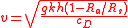
where g is gravitational acceleration,
k relates the height, h, and surface area, A,
of the balloon to its volume: V = khA;
Rs is the equivalent "gas constant" of the balloon,
Ra is the gas constant of the air
and cD is the drag coefficient of the balloon.
Substituting some sensible values for each of the constants,
k=1. (the balloon is a perfect cylinder), h=2. m, cD = 1.
and Ra is the gas constant of helium,
returns an ascent rate of 4.1 m/s. Compare this with the
values shown in the histogram which compiles all of the
radiosonde launches from the Polarstern research vessel
over a period of eleven years between 1992 and 2003.
or reanalysis
data,
interpolation
is likely the most appropriate method for performing any type of comparison.
A specific point in both physical position and time is easy to locate
within the grid and interpolation performed between the nearest neighbors.
Linear interpolation
(bilinear
, trilinear
etc.) is the most common,
though cubic is used as well but is probably not worth the extra computational overhead.
If the variable of interest has a relatively smooth rate of change (temperature is a good example of this because it
has a diffusion mechanism, radiative transfer
, not available to other atmospheric variables),
then interpolation can eliminate much of the error associated with collocation.
Interpolation may also be appropriate for many types of satellite instruments,
for instance a cross-track scanning instrument like Landsat.
In data derived from the Advanced Microwave Sounding Unit
(AMSU) are
interpolated (although not for the purposes of collocation) using a slight variation
of trilinear interpolation.
Since measurements within a single scan track are laid out in an approximately rectangular
grid, bilinear interpolation can be performed.
By searching for the nearest overlapping scan track both forwards and backwards in time,
the spatial interpolates can then be interpolated in time.
This technique works better with derived quantities rather than raw brightness temperatures since
the scan angle will already have been accounted for.
For instruments with a more irregular sampling pattern, such as the Advanced Microwave
Scanning Radiometer-EOS (AMSR-E)
instrument which has a circular scanning pattern,
we need a more general form of interpolation such as kernel estimation.
A method commonly used for this particular instrument, as well as SSM/I,
is a simple daily average within regularly gridded, spatial bins
.
s taken during the
Pol-Ice Campaign are an excellent example since they illustrate many of the most important principles as well as demonstrating the necessity of taking into account the individual case. The Pol-Ice campaign was conducted in the N. Baltic in March 2007 as part of the SMOS-Ice project in preparation for the launch of the Soil Moisture and Ocean Salinity satellite
.
Because of the low frequency of the SMOS instrument, it is hoped that it will render
information on sea ice thickness, therefore the campaign comprised measurements
of both sea ice thickness and emitted brightness temperature.
Brightness temperatures were measured with the EMIRAD L-band microwave radiometer
carried on board an airplane. Ice thickness was measured with the E-M Bird ice thickness meter which was carried by a helicopter. The E-M Bird measures ice thickness with a combination of inductance measurements to determine the location of the ice-water interface and a laser altimeter
to measure the height of the ice surface.
The map above shows the flight tracks of both instruments which were approximately coincident but obviously subject to pilot error.
Since the flight paths of both aircraft were approximately linear, the first step in the collocation process was to convert all the coincident flights to Cartesian coordinates with the x-axis being lateral distance and the y-axis transverse distance. In this way, collocations can be performed in two ways: crudely, by matching only the x distances, and more precisely by matching both coordinates.
More importantly, the footprint size of the radiometer is many times larger
than that of the E-M Bird meter. The figure to the left shows
the antenna response function
for the radiometer.
The full width at half maximum
is 31 degrees.
Since the aircraft was flying at approximately 500 m, this translates
to a footprint size of 200 m or more.
Meanwhile, the footprint size of the E-M Bird was roughly 40 m
with a sample spacing of only 2 to 4 m.
Rather than looking to nearest neighbors, which would have produced
poor results, a weighted average of the thickness measurements was
performed for each radiometer measurement.
Weights were calculated based on the radiometer response function which is almost
a perfect Gaussian up to about 45 degrees.
Points could be excluded based on distance along the flight
path.
For validation of sea ice emissivity forward model calculations,
this was further refined by performing an emissivity calculation
for each thickness measurement and averaging over the radiometer
footprint.
The figure below illustrates relative measurement locations
from each of the instruments used in the Pol-Ice campaign.
Two overpasses are shown: one from the airplane carrying the
EMIRAD radiometer and one from the helicopter carrying the
E-M Bird instrument.
The x-axis is along the line of the flight path.
EMIRAD footprints are drawn with lines, E-M Bird
inductance measurements are represented by circles
and LIDAR measurements with dots.
Remote sensing
Remote sensing is the acquisition of information about an object or phenomenon, without making physical contact with the object. In modern usage, the term generally refers to the use of aerial sensor technologies to detect and classify objects on Earth by means of propagated signals Remote sensing...
to match measurements from two or more different instruments.
This is done for two main reasons:
for validation purposes when comparing measurements of the same variable,
and to relate measurements of two different variables
either for performing retrievals or for prediction.
In the second case the data is later fed into some type of statistical
inverse method
Inverse problem
An inverse problem is a general framework that is used to convert observed measurements into information about a physical object or system that we are interested in...
such as a neural network
Neural network
The term neural network was traditionally used to refer to a network or circuit of biological neurons. The modern usage of the term often refers to artificial neural networks, which are composed of artificial neurons or nodes...
, statistical classification algorithm,
kernel estimator or a linear least squares.
In principal, most collocation problems can be solved by a nearest neighbor search
Nearest neighbor search
Nearest neighbor search , also known as proximity search, similarity search or closest point search, is an optimization problem for finding closest points in metric spaces. The problem is: given a set S of points in a metric space M and a query point q ∈ M, find the closest point in S to q...
,
but in practice there are many other considerations involved and the best method is
highly specific to the particular matching of instruments.
Here we deal with some of the most important considerations along with specific examples.
There are at least two main considerations when performing collocations.
The first is the sampling pattern of the instrument.
Measurements may be dense and regular, such as those from a cross-track
scanning satellite instrument. In this case, some form of interpolation
Interpolation
In the mathematical field of numerical analysis, interpolation is a method of constructing new data points within the range of a discrete set of known data points....
may be appropriate. On the other hand, the measurements may be
sparse, such as a one-off field campaign designed for some
particular validation exercise.
The second consideration is the instrument footprint, which
can range from something approaching a point measurement
such as that of a radiosonde
Radiosonde
A radiosonde is a unit for use in weather balloons that measures various atmospheric parameters and transmits them to a fixed receiver. Radiosondes may operate at a radio frequency of 403 MHz or 1680 MHz and both types may be adjusted slightly higher or lower as required...
, or it might be several
kilometers in diameter such as that of a satellite-mounted,
microwave radiometer. In the latter case, it is appropriate
to take into account the instrument antenna pattern when
making comparisons with another instrument having both a smaller
footprint and a denser sampling, that is, several measurements
from the one instrument will fit into the footprint of the other.
Just as the instrument has a spatial footprint, it will also have
a temporal footprint, often called the integration time.
While the integration time is usually less than a second,
which for meteorological applications is essentially instantaneous,
there are many instances where some form of time averaging can considerably
ease the collocation process.
The collocations will need to be screened based on both the time
and length scales of the phenomenon of interest.
This will further facilitate the collocation process since
remote sensing and other measurement data is almost always
binned
Data binning
Data binning is a data pre-processing technique used to reduce the effects of minor observation errors. The original data values which fall in a given small interval, a bin, are replaced by a value representative of that interval, often the central value...
in some way.
Certain atmospheric phenomena such as clouds or convection are quite transient
so that we need not consider collocations with a time error of more than an hour or so.
Sea ice, on the other hand, moves and evolves quite slowly, so that
measurements separated by as much as a day or more might still be useful.
Satellites
The satelliteSatellite
In the context of spaceflight, a satellite is an object which has been placed into orbit by human endeavour. Such objects are sometimes called artificial satellites to distinguish them from natural satellites such as the Moon....
s that most concern us are those with a low-Earth
Low Earth orbit
A low Earth orbit is generally defined as an orbit within the locus extending from the Earth’s surface up to an altitude of 2,000 km...
, polar orbit
Polar orbit
A polar orbit is an orbit in which a satellite passes above or nearly above both poles of the body being orbited on each revolution. It therefore has an inclination of 90 degrees to the equator...
since geostationary satellites view the same point throughout their lifetime.
The diagram shows measuremnts from AMSU-B
Advanced Microwave Sounding Unit
The Advanced microwave sounding unit is a multi-channel microwave radiometer installed on meteorological satellites. The instrument examines several bands of microwave radiation from the atmosphere to perform atmospheric sounding of temperature and moisture levels.-Products:Level-1 radiance data...
instruments mounted on three satellites over a period of 12 hours.
This illustrates both the orbit path and the scan pattern which runs crosswise.
Since the orbit
Orbit
In physics, an orbit is the gravitationally curved path of an object around a point in space, for example the orbit of a planet around the center of a star system, such as the Solar System...
of a satellite is deterministic,
barring orbit maneuvers
Orbital maneuver
In spaceflight, an orbital maneuver is the use of propulsion systems to change the orbit of a spacecraft.For spacecraft far from Earth—for example those in orbits around the Sun—an orbital maneuver is called a deep-space maneuver .-delta-v:...
, we can predict the location of the
satellite at a given time and, by extension, the location of
the measurement pixels.
In theory, collocations can be performed by inverting the
determining equations starting from the desired time period.
In practice, partially processed data (usually referred to as
level 1b, 1c or level 2) contain the coordinates of each of
the measurement pixels and
it is common to simply feed these coordinates to a nearest neighbor search.
As mentioned previously, the satellite data is always binned
Data binning
Data binning is a data pre-processing technique used to reduce the effects of minor observation errors. The original data values which fall in a given small interval, a bin, are replaced by a value representative of that interval, often the central value...
in some manner.
At minimum, the data will be arranged in
swaths extending from pole to pole.
The swaths will be labelled by time period and the
approximate location known.
Radiosondes
RadiosondeRadiosonde
A radiosonde is a unit for use in weather balloons that measures various atmospheric parameters and transmits them to a fixed receiver. Radiosondes may operate at a radio frequency of 403 MHz or 1680 MHz and both types may be adjusted slightly higher or lower as required...
s are particularly important for collocation studies
because they measure atmospheric variables more accurately and more
directly than satellite or other remote-sensing instruments.
In addition, radiosonde samples are effectively instantaneous point measurements.
One issue with radiosondes carried aloft by weather balloon
Weather balloon
A weather or sounding balloon is a balloon which carries instruments aloft to send back information on atmospheric pressure, temperature, humidity and wind speed by means of a small, expendable measuring device called a radiosonde...
s is
balloon drift. In,
this is handled by averaging all the satellite pixels within a 50 km radius
of the balloon launch.
If high-resolution sonde data, which normally has a constant
sampling rate or includes the measurement time, is used,
then the lateral motion can be traced from the wind data.
Even with low-resolution data, the motion can still
be approximated by assuming a constant ascent rate.
Excepting a short bit towards the end,
the linear ascent can be clearly seen in the figure above.
We can show that the ascent rate of a balloon is given
by the following equation
where g is gravitational acceleration,
k relates the height, h, and surface area, A,
of the balloon to its volume: V = khA;
Rs is the equivalent "gas constant" of the balloon,
Ra is the gas constant of the air
and cD is the drag coefficient of the balloon.
Substituting some sensible values for each of the constants,
k=1. (the balloon is a perfect cylinder), h=2. m, cD = 1.
and Ra is the gas constant of helium,
returns an ascent rate of 4.1 m/s. Compare this with the
values shown in the histogram which compiles all of the
radiosonde launches from the Polarstern research vessel
over a period of eleven years between 1992 and 2003.
Interpolation
For gridded data such as assimilationData assimilation
Applications of data assimilation arise in many fields of geosciences, perhaps most importantly in weather forecasting and hydrology. Data assimilation proceeds by analysis cycles...
or reanalysis
Meteorological reanalysis
A meteorological reanalysis is a meteorological data assimilation project which aims to assimilate historical observational data spanning an extended period, using a single consistent assimilation scheme throughout....
data,
interpolation
Interpolation
In the mathematical field of numerical analysis, interpolation is a method of constructing new data points within the range of a discrete set of known data points....
is likely the most appropriate method for performing any type of comparison.
A specific point in both physical position and time is easy to locate
within the grid and interpolation performed between the nearest neighbors.
Linear interpolation
Linear interpolation
Linear interpolation is a method of curve fitting using linear polynomials. Lerp is an abbreviation for linear interpolation, which can also be used as a verb .-Linear interpolation between two known points:...
(bilinear
Bilinear interpolation
In mathematics, bilinear interpolation is an extension of linear interpolation for interpolating functions of two variables on a regular grid. The interpolated function should not use the term of x^2 or y^2, but x y, which is the bilinear form of x and y.The key idea is to perform linear...
, trilinear
Trilinear interpolation
Trilinear interpolation is a method of multivariate interpolation on a 3-dimensional regular grid. It approximates the value of an intermediate point within the local axial rectangular prism linearly, using data on the lattice points...
etc.) is the most common,
though cubic is used as well but is probably not worth the extra computational overhead.
If the variable of interest has a relatively smooth rate of change (temperature is a good example of this because it
has a diffusion mechanism, radiative transfer
Radiative transfer
Radiative transfer is the physical phenomenon of energy transfer in the form of electromagnetic radiation. The propagation of radiation through a medium is affected by absorption, emission and scattering processes. The equation of radiative transfer describes these interactions mathematically...
, not available to other atmospheric variables),
then interpolation can eliminate much of the error associated with collocation.
Interpolation may also be appropriate for many types of satellite instruments,
for instance a cross-track scanning instrument like Landsat.
In data derived from the Advanced Microwave Sounding Unit
Advanced Microwave Sounding Unit
The Advanced microwave sounding unit is a multi-channel microwave radiometer installed on meteorological satellites. The instrument examines several bands of microwave radiation from the atmosphere to perform atmospheric sounding of temperature and moisture levels.-Products:Level-1 radiance data...
(AMSU) are
interpolated (although not for the purposes of collocation) using a slight variation
of trilinear interpolation.
Since measurements within a single scan track are laid out in an approximately rectangular
grid, bilinear interpolation can be performed.
By searching for the nearest overlapping scan track both forwards and backwards in time,
the spatial interpolates can then be interpolated in time.
This technique works better with derived quantities rather than raw brightness temperatures since
the scan angle will already have been accounted for.
For instruments with a more irregular sampling pattern, such as the Advanced Microwave
Scanning Radiometer-EOS (AMSR-E)
Aqua (satellite)
Aqua is a multi-national NASA scientific research satellite in orbit around the Earth, studying the precipitation, evaporation, and cycling of water. It is the second major component of the Earth Observing System preceded by Terra and followed by Aura .The name "Aqua" comes from the Latin word...
instrument which has a circular scanning pattern,
we need a more general form of interpolation such as kernel estimation.
A method commonly used for this particular instrument, as well as SSM/I,
is a simple daily average within regularly gridded, spatial bins
.
Example: Pol-Ice Campaign
Collocations of sea ice thickness and brightness temperatureBrightness temperature
Brightness temperature is the temperature a black body in thermal equilibrium with its surroundings would have to be to duplicate the observed intensity of a grey body object at a frequency \nu....
s taken during the
Pol-Ice Campaign are an excellent example since they illustrate many of the most important principles as well as demonstrating the necessity of taking into account the individual case. The Pol-Ice campaign was conducted in the N. Baltic in March 2007 as part of the SMOS-Ice project in preparation for the launch of the Soil Moisture and Ocean Salinity satellite
Soil Moisture and Ocean Salinity satellite
The Soil Moisture and Ocean Salinity Satellite is a part of ESA's Living Planet Programme intended to provide new insights into Earth's water cycle and climate...
.
Because of the low frequency of the SMOS instrument, it is hoped that it will render
information on sea ice thickness, therefore the campaign comprised measurements
of both sea ice thickness and emitted brightness temperature.
Brightness temperatures were measured with the EMIRAD L-band microwave radiometer
carried on board an airplane. Ice thickness was measured with the E-M Bird ice thickness meter which was carried by a helicopter. The E-M Bird measures ice thickness with a combination of inductance measurements to determine the location of the ice-water interface and a laser altimeter
LIDAR
LIDAR is an optical remote sensing technology that can measure the distance to, or other properties of a target by illuminating the target with light, often using pulses from a laser...
to measure the height of the ice surface.
The map above shows the flight tracks of both instruments which were approximately coincident but obviously subject to pilot error.
Since the flight paths of both aircraft were approximately linear, the first step in the collocation process was to convert all the coincident flights to Cartesian coordinates with the x-axis being lateral distance and the y-axis transverse distance. In this way, collocations can be performed in two ways: crudely, by matching only the x distances, and more precisely by matching both coordinates.
More importantly, the footprint size of the radiometer is many times larger
than that of the E-M Bird meter. The figure to the left shows
the antenna response function
Radiation pattern
In the field of antenna design the term radiation pattern most commonly refers to the directional dependence of the strength of the radio waves from the antenna or other source ....
for the radiometer.
The full width at half maximum
Full width at half maximum
Full width at half maximum is an expression of the extent of a function, given by the difference between the two extreme values of the independent variable at which the dependent variable is equal to half of its maximum value....
is 31 degrees.
Since the aircraft was flying at approximately 500 m, this translates
to a footprint size of 200 m or more.
Meanwhile, the footprint size of the E-M Bird was roughly 40 m
with a sample spacing of only 2 to 4 m.
Rather than looking to nearest neighbors, which would have produced
poor results, a weighted average of the thickness measurements was
performed for each radiometer measurement.
Weights were calculated based on the radiometer response function which is almost
a perfect Gaussian up to about 45 degrees.
Points could be excluded based on distance along the flight
path.
For validation of sea ice emissivity forward model calculations,
this was further refined by performing an emissivity calculation
for each thickness measurement and averaging over the radiometer
footprint.
The figure below illustrates relative measurement locations
from each of the instruments used in the Pol-Ice campaign.
Two overpasses are shown: one from the airplane carrying the
EMIRAD radiometer and one from the helicopter carrying the
E-M Bird instrument.
The x-axis is along the line of the flight path.
EMIRAD footprints are drawn with lines, E-M Bird
inductance measurements are represented by circles
and LIDAR measurements with dots.