
Clontarf Road railway station
Encyclopedia
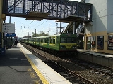
Clontarf Road railway station is a railway station in Dublin, Ireland
, on the DART
commuter rail line.
, on the border between Clontarf
and Fairview
, and serves people living and working in those areas, as well as Marino
and East Wall
. The station is situated just north of Fairview DART depot
. It was built in the late 1990s to serve the densely populated areas about, and also East Point Business Park
.
village centre.
This original Clontarf station was opened on 25 May 1844 and finally closed on 3 September 1956.
Republic of Ireland
Ireland , described as the Republic of Ireland , is a sovereign state in Europe occupying approximately five-sixths of the island of the same name. Its capital is Dublin. Ireland, which had a population of 4.58 million in 2011, is a constitutional republic governed as a parliamentary democracy,...
, on the DART
Dublin Area Rapid Transit
The Dublin Area Rapid Transit is part of the suburban railway network in Ireland, running mainly along the coastline of Dublin Bay on the Trans-Dublin route, from Greystones in County Wicklow, through Dublin to Howth and Malahide in County Dublin.Trains are powered via a 1500V DC overhead catenary...
commuter rail line.
Location
It is located at the south-western end of Clontarf Road on Dublin's NorthsideNorthside (Dublin)
The Northside is the area in County Dublin, Ireland bounded to the south by the River Liffey to the east by Dublin Bay, to the north and west by the boundaries of County Dublin.- Introduction :...
, on the border between Clontarf
Clontarf, Dublin
Clontarf is a coastal suburb on the northside of Dublin, in Ireland. It is most famous for giving the name to the Battle of Clontarf in 1014, in which Brian Boru, High King of Ireland, defeated the Vikings of Dublin and their allies, the Irish of Leinster. This battle, which extended to districts...
and Fairview
Fairview, Dublin
Fairview is a coastal district on the Northside of Dublin, Ireland, in the jurisdiction of Dublin City Council. Part of the area forms Fairview Park, on land reclaimed from the sea.-Location and access:...
, and serves people living and working in those areas, as well as Marino
Marino, Dublin
Marino is a Northside suburb located in Dublin, Ireland.-Location and access:Marino encompasses the area within the boundaries of Sion Hill Road, Gracepark Road, Philipsburgh Avenue , Malahide Road and Shelmartin Terrace. Marino borders other Northside areas such as Fairview, Donnycarney and...
and East Wall
East Wall
East Wall is an inner city area of the Northside of Dublin, Ireland.-Location:East Wall is bounded by the North Strand Road to the west, by North Wall and the Royal Canal to the south, and was bounded by East Wall Road, Dublin to the north until land reclamation extended that part...
. The station is situated just north of Fairview DART depot
Fairview DART depot
Fairview DART depot is a railway depot used for servicing electrical multiple units on the Dublin Area Rapid Transit system. There is a three road shed, train wash and sidings. It is located just south of Clontarf Road DART station on the Dublin-Belfast railway line. However, maintenance on DART...
. It was built in the late 1990s to serve the densely populated areas about, and also East Point Business Park
East Point Business Park
East Point Office Park in the docklands area of Dublin, Ireland is one of the country's largest business parks, being the place of employment for thousands of people. It is situated in the East Wall area....
.
Previous station for area
The area was last served by the old Clontarf Station, almost a kilometre north on the line. The remnants of that station can still be seen at the rail bridge over Howth Road, halfway between the start of that road and KillesterKillester
Killester is a small, largely residential suburb of Dublin and lies on the Northside of the city.-Location and access:Killester is located between Clontarf, Donnycarney, Raheny and Artane, and it falls within the postal districts of Dublin 3 or 5. St. Anne's Park lies just beyond Killester on the...
village centre.
This original Clontarf station was opened on 25 May 1844 and finally closed on 3 September 1956.