

Climate of Alabama
Encyclopedia
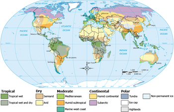
Humid subtropical climate
A humid subtropical climate is a climate zone characterized by hot, humid summers and mild to cool winters...
(Cfa) under the Koppen Climate Classification. The average annual temperature is 64 °F (18 °C). Temperatures tend to be warmer in the southern part of the state with its proximity to the Gulf of Mexico, while the northern parts of the state, especially in the Appalachian Mountains in the northeast, tend to be slightly cooler. Generally, Alabama has very hot summers and mild winters with copious precipitation throughout the year. Alabama receives an average of 56 inches (1,422.4 mm) of rainfall annually and enjoys a lengthy growing season of up to 300 days in the southern part of the state. Hail
Hail
Hail is a form of solid precipitation. It consists of balls or irregular lumps of ice, each of which is referred to as a hail stone. Hail stones on Earth consist mostly of water ice and measure between and in diameter, with the larger stones coming from severe thunderstorms...
storms occur occasionally in the spring and summer, but are seldom destructive. Heavy fog
Fog
Fog is a collection of water droplets or ice crystals suspended in the air at or near the Earth's surface. While fog is a type of stratus cloud, the term "fog" is typically distinguished from the more generic term "cloud" in that fog is low-lying, and the moisture in the fog is often generated...
s are rare, and are confined chiefly to the coast. Thunderstorm
Thunderstorm
A thunderstorm, also known as an electrical storm, a lightning storm, thundershower or simply a storm is a form of weather characterized by the presence of lightning and its acoustic effect on the Earth's atmosphere known as thunder. The meteorologically assigned cloud type associated with the...
s occur throughout the year - they are most common in the summer, but most severe in the spring and fall, when destructive winds and tornado
Tornado
A tornado is a violent, dangerous, rotating column of air that is in contact with both the surface of the earth and a cumulonimbus cloud or, in rare cases, the base of a cumulus cloud. They are often referred to as a twister or a cyclone, although the word cyclone is used in meteorology in a wider...
es occasionally occur. Hurricanes
Tropical cyclone
A tropical cyclone is a storm system characterized by a large low-pressure center and numerous thunderstorms that produce strong winds and heavy rain. Tropical cyclones strengthen when water evaporated from the ocean is released as the saturated air rises, resulting in condensation of water vapor...
are quite common in the state, especially in the southern part, and major hurricanes occasionally strike the coast which can be very destructive.
Temperature
Gulf of Mexico
The Gulf of Mexico is a partially landlocked ocean basin largely surrounded by the North American continent and the island of Cuba. It is bounded on the northeast, north and northwest by the Gulf Coast of the United States, on the southwest and south by Mexico, and on the southeast by Cuba. In...
, and in the north by the elevation above the sea. The average annual temperature is highest in the southwest along the coast, and lowest in the northeast among the highlands. Thus at Mobile the annual mean is 67 °F (19 °C), the mean for the summer 81 °F (27 °C), and for the winter 52 °F (11 °C); and at Valley Head, in De Kalb county, the annual mean is 59 °F (15 °C), the mean for the summer 75 °F (24 °C), and for the winter 41 °F (5 °C). At Montgomery, in the central region, the average annual temperature is 66 °F (19 °C), with a winter average of 49 °F (9 °C), and a summer average of 81 °F (27 °C). The average winter minimum for the entire state is 35 °F (2 °C), and there is an average of 35 days in each year in which the thermometer falls below the freezing-point. At extremely rare intervals the thermometer has fallen below zero (-18 °C), as was the case in the remarkable cold wave of the 12th-13 February 1899, when an absolute minimum of -17 °F (-29 °C) was registered at Valley Head
Valley Head, Alabama
Valley Head is a town in DeKalb County, Alabama, United States. At the 2000 census the population was 611.-Geography:Valley Head is located at .According to the U.S. Census Bureau, the town has a total area of , all of it land....
. The highest temperature ever recorded was 109 °F (43 °C) in Talladega
Talladega County, Alabama
Talladega County is a county of the U.S. state of Alabama. Talladega is a Muscogee Native American word derived from TVLVTEKE, which means "border town." As of 2010, the population was 82,291...
county in 1902. Winters are generally mild in Alabama, as they are throughout most of the southeastern United States
Southeastern United States
The Southeastern United States, colloquially referred to as the Southeast, is the eastern portion of the Southern United States. It is one of the most populous regions in the United States of America....
, with average January low temperatures around 40 °F (4.4 °C) in Mobile, around 31 °F (-.6 °C) in Huntsville, around 36 °F (2.2 °C) in Montgomery, and around 33 °F (0.555555555559977 °C) in Birmingham.
| Monthly normal high and low temperatures for various Alabama cities | |||||||||||||||||||||||||
| Month | Jan | Feb | Mar | Apr | May | Jun | Jul | Aug | Sep | Oct | Nov | Dec | |||||||||||||
|---|---|---|---|---|---|---|---|---|---|---|---|---|---|---|---|---|---|---|---|---|---|---|---|---|---|
| City | temp | °F | °C | °F | °C | °F | °C | °F | °C | °F | °C | °F | °C | °F | °C | °F | °C | °F | °C | °F | °C | °F | °C | °F | °C |
| Birmingham | high | 54 | 12.2 | 58 | 14.4 | 67 | 19.4 | 74 | 23.3 | 82 | 27.8 | 88 | 31.1 | 91 | 32.8 | 91 | 32.8 | 85 | 29.4 | 75 | 23.9 | 65 | 18.3 | 56 | 13.3 |
| low | 33 | 0.555555555559977 | 37 | 2.8 | 43 | 6.1 | 50 | 10 | 59 | 15 | 67 | 19.4 | 71 | 21.7 | 70 | 21.1 | 64 | 17.8 | 52 | 11.1 | 43 | 6.1 | 36 | 2.2 | |
| Huntsville | high | 50 | 10 | 55 | 12.8 | 64 | 17.8 | 73 | 22.8 | 80 | 26.7 | 87 | 30.6 | 90 | 32.2 | 90 | 32.2 | 84 | 28.9 | 74 | 23.3 | 63 | 17.2 | 53 | 11.7 |
| low | 31 | -.6 | 35 | 1.7 | 42 | 5.6 | 49 | 9.4 | 59 | 15 | 66 | 18.9 | 70 | 21.1 | 69 | 20.6 | 62 | 16.7 | 50 | 10 | 41 | 5 | 34 | 1.1 | |
| Mobile | high | 61 | 16.1 | 64 | 17.8 | 71 | 21.7 | 78 | 25.6 | 85 | 29.4 | 89 | 31.7 | 91 | 32.8 | 91 | 32.8 | 87 | 30.6 | 79 | 26.1 | 71 | 21.7 | 63 | 17.2 |
| low | 40 | 4.4 | 43 | 6.1 | 49 | 9.4 | 55 | 12.8 | 64 | 17.8 | 70 | 21.1 | 73 | 22.8 | 73 | 22.8 | 68 | 20 | 56 | 13.3 | 49 | 9.4 | 42 | 5.6 | |
| Montgomery | high | 58 | 14.4 | 62 | 16.7 | 70 | 21.1 | 77 | 25 | 84 | 28.9 | 90 | 32.2 | 93 | 33.9 | 92 | 33.3 | 88 | 31.1 | 79 | 26.1 | 69 | 20.6 | 60 | 15.6 |
| low | 36 | 2.2 | 39 | 3.9 | 46 | 7.8 | 52 | 11.1 | 61 | 16.1 | 68 | 20 | 72 | 22.2 | 71 | 21.7 | 65 | 18.3 | 54 | 12.2 | 44 | 6.7 | 38 | 3.3 | |
Precipitation
The amount of precipitation is greatest along the coast (62 inches/1,574 mm) and evenly distributed through the rest of the state (about 52 inches/1,320 mm). Although snow is a rare event in much of Alabama, areas of the state north of Montgomery may receive a dusting of snow a few times every winter, with an occasional moderately heavy snowfall every few years. Historic snowfall events include New Year's Eve 1963 snowstormNew Year's Eve 1963 snowstorm
The New Year's Eve 1963 snowstorm was a significant winter storm occurring from December 31, 1963 to January 1, 1964 over most of the Southern United States. The storm began when a surface low-pressure system moved northward through the eastern Gulf of Mexico and up the fall line east of the...
and the 1993 Storm of the Century. The annual average snowfall for the Birmingham area is 2 inches (50.8 mm) per year. In the southern Gulf coast, snowfall is less frequent, sometimes going several years without any snowfall. Heavy snowfall can occur, such as during the New Year's Eve 1963 snowstorm
New Year's Eve 1963 snowstorm
The New Year's Eve 1963 snowstorm was a significant winter storm occurring from December 31, 1963 to January 1, 1964 over most of the Southern United States. The storm began when a surface low-pressure system moved northward through the eastern Gulf of Mexico and up the fall line east of the...
and the 1993 Storm of the Century.
Hazards
Alabama is also prone to tropical storms and even hurricanes. Areas of the state far away from the Gulf are not immune to the effects of the storms, which often dump tremendous amounts of rain as they move inland and weaken. South Alabama reports many thunderstorms. The Gulf Coast, around Mobile Bay, averages between 100 and 110 days per year with thunder reported, which eastern and northwest Alabama have 70 to 80 thunderstorm days per year. Occasionally, thunderstorms are severe with frequent lightningLightning
Lightning is an atmospheric electrostatic discharge accompanied by thunder, which typically occurs during thunderstorms, and sometimes during volcanic eruptions or dust storms...
and large hail
Hail
Hail is a form of solid precipitation. It consists of balls or irregular lumps of ice, each of which is referred to as a hail stone. Hail stones on Earth consist mostly of water ice and measure between and in diameter, with the larger stones coming from severe thunderstorms...
– the central and northern parts of the state are most vulnerable to this type of storm. Alabama ranks seventh in the number of deaths from lightning and ninth in the number of deaths from lightning strikes per capita.
Sometimes tornado
Tornado
A tornado is a violent, dangerous, rotating column of air that is in contact with both the surface of the earth and a cumulonimbus cloud or, in rare cases, the base of a cumulus cloud. They are often referred to as a twister or a cyclone, although the word cyclone is used in meteorology in a wider...
es occur – these are common throughout the state, although the peak season for tornadoes varies from the northern to southern parts of the state. Alabama, along with Kansas
Kansas
Kansas is a US state located in the Midwestern United States. It is named after the Kansas River which flows through it, which in turn was named after the Kansa Native American tribe, which inhabited the area. The tribe's name is often said to mean "people of the wind" or "people of the south...
, has the most reported EF5 tornadoes
Enhanced Fujita Scale
The Enhanced Fujita Scale rates the strength of tornadoes in the United States based on the damage they cause.Implemented in place of the Fujita scale introduced in 1971 by Ted Fujita, it began operational use on February 1, 2007. The scale has the same basic design as the original Fujita scale:...
than any other state – according to statistics from the National Climatic Data Center
National Climatic Data Center
The United States National Climatic Data Center in Asheville, North Carolina is the world's largest active archive of weather data. The center became established in late 1951, with the move into the new facility occurring in early 1952....
for the period January 1, 1950, to October 31, 2006. An F5 tornado is the most powerful of its kind. Several long – tracked F5 tornadoes have contributed to Alabama reporting more tornado fatalities than any other state except for Texas
Texas
Texas is the second largest U.S. state by both area and population, and the largest state by area in the contiguous United States.The name, based on the Caddo word "Tejas" meaning "friends" or "allies", was applied by the Spanish to the Caddo themselves and to the region of their settlement in...
and Mississippi
Mississippi
Mississippi is a U.S. state located in the Southern United States. Jackson is the state capital and largest city. The name of the state derives from the Mississippi River, which flows along its western boundary, whose name comes from the Ojibwe word misi-ziibi...
. The Super Outbreak
Super Outbreak
The Super Outbreak is the second largest tornado outbreak on record for a single 24-hour period, just behind the tornado outbreak of April 25–28, 2011...
in March 1974 badly affected Alabama. The northern part of the state – along the Tennessee Valley – is one of the areas in the US most vulnerable to violent tornadoes. The area of Alabama and Mississippi most affected by tornadoes is sometimes referred to as Dixie Alley
Dixie Alley
Dixie Alley is a nickname sometimes given to areas of the southern United States that are particularly vulnerable to strong or violent tornadoes...
, as distinct from the Tornado Alley
Tornado Alley
Tornado Alley is a colloquial and popular media term that most often refers to the area of the United States where tornadoes are most frequent. Although an official location is not defined, the area between the Rocky Mountains and Appalachian Mountains is usually associated with it.The areas...
of the Southern Plains. Alabama is one of the few places in the world that has a secondary tornado season (November and December) along with the spring severe weather season.