
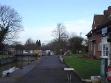
Clifton Lock
Encyclopedia
Clifton Lock is a lock on River Thames
in Oxfordshire
, England
. It is located south of the village of Clifton Hampden
and north of Long Wittenham
. It is at the start of the Clifton Cut, which bypasses the river to the north of Long Wittenham.
The lock was completed in 1822 by the Thames Navigation Commissioners.
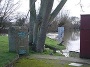
The main weir, which was built thirteen years later than the lock, runs across the old navigation of the river. A smaller weir runs just above the lock.
 The construction of the lock cut was delayed because the owner of the land was "a lunatic", but it was eventually completed in 1822 together with the lock. No weir was built at the time, giving rise to complaints. In 1826, the Lord Mayor of London visited Oxford by boat, and the City Barge, shallop and attendant boats were "detained at Clifton a considerable length of time.
The weir was eventually erected on the old navigation in 1835. It was enlarged by 1877 and a tumbling bay was created close to the lock. The lock cut bridges were rebuilt in 1884.
. Just before Sutton Bridge
the river again divides between an old course via Sutton Courtenay
and the Culham Cut.
The Thames Path
follows the northern bank all the way to Culham Lock.
River Thames
The River Thames flows through southern England. It is the longest river entirely in England and the second longest in the United Kingdom. While it is best known because its lower reaches flow through central London, the river flows alongside several other towns and cities, including Oxford,...
in Oxfordshire
Oxfordshire
Oxfordshire is a county in the South East region of England, bordering on Warwickshire and Northamptonshire , Buckinghamshire , Berkshire , Wiltshire and Gloucestershire ....
, England
England
England is a country that is part of the United Kingdom. It shares land borders with Scotland to the north and Wales to the west; the Irish Sea is to the north west, the Celtic Sea to the south west, with the North Sea to the east and the English Channel to the south separating it from continental...
. It is located south of the village of Clifton Hampden
Clifton Hampden
Clifton Hampden is a village and civil parish on the north bank of the River Thames, just over east of Abingdon in Oxfordshire. Since 1932 the civil parish has included the village of Burcot, east of Clifton Hampden.-Manor:...
and north of Long Wittenham
Long Wittenham
Long Wittenham is a village and civil parish north of Didcot, and southeast of Abingdon. It was part of Berkshire until the 1974 boundary changes transferred it from Berkshire to Oxfordshire, and from the former Wallingford Rural District to the new district of South Oxfordshire.It used to be...
. It is at the start of the Clifton Cut, which bypasses the river to the north of Long Wittenham.
The lock was completed in 1822 by the Thames Navigation Commissioners.
The main weir, which was built thirteen years later than the lock, runs across the old navigation of the river. A smaller weir runs just above the lock.
History
Clifton is one of the few lock sites on the non-tidal river where there was not a pre-existing weir and flash lock, although there was an important ferry. Problems to navigation had long been recognised and the first suggestions for creating a lock "near Clifton Ferry" occurred in 1793, being raised again in 1811.The weir was eventually erected on the old navigation in 1835. It was enlarged by 1877 and a tumbling bay was created close to the lock. The lock cut bridges were rebuilt in 1884.
Access to the Lock
The lock is at the end of a long track which starts on the A415 road to Abingdon just after it leaves Clifton Hampden (10 mph signs). On the way to the lock, this track meets another track from the end of the High Street Clifton Hampden. The status of these tracks is unclear as signs state "Farm only".Reach above the lock
The Clifton cut takes the river for nearly a mile before it resumes its natural course. The reach is relatively dull and uninteresting, crossed about halfway along by the Appleford Railway BridgeAppleford Railway Bridge
Appleford Railway Bridge carries the Cherwell Valley Line from Didcot to Oxford across the River Thames near the village of Appleford-on-Thames, Oxfordshire, England. It crosses the Thames on the reach between Clifton Lock and Culham Lock. The bridge was under construction in December...
. Just before Sutton Bridge
Sutton Bridge, Oxfordshire
Sutton Bridge, Oxfordshire is a road bridge across the River Thames near the village of Sutton Courtenay, Oxfordshire, England. It is a stone structure built in 1807 with three arches over the main river and two smaller ones across the flood plain. An extension was built in 1809 across the Culham...
the river again divides between an old course via Sutton Courtenay
Sutton Courtenay
Sutton Courtenay is a village and civil parish on the River Thames south of Abingdon and northwest of Didcot. It was part of Berkshire until the 1974 boundary changes transferred it to Oxfordshire.-Today:...
and the Culham Cut.
The Thames Path
Thames Path
The Thames Path is a National Trail, opened in 1996, following the length of the River Thames from its source near Kemble in Gloucestershire to the Thames Barrier at Charlton. It is about long....
follows the northern bank all the way to Culham Lock.
External links
- View from Clifton Lock from geograph.org.uk