

City of South Melbourne
Encyclopedia
The City of South Melbourne was a Local Government Area located about 2 kilometres (1.2 mi) south of Melbourne
, the state capital of Victoria
, Australia
, on the south bank of the Yarra River
. The city covered an area of 8.91 square kilometres (3.44 sq mi), and existed from 1855 until 1994.
The council area was bounded by the Yarra River
to the north, Fraser and Lorne Streets to the south, the Port Phillip
foreshore and Pickles Street to the west, and St Kilda Road
to the east.
on 26 May 1855, and became a Town on 1 March 1872. It was proclaimed a City and was renamed to South Melbourne on 21 September 1883.
On 18 November 1993, a small portion around Southbank
and the Victorian Arts Centre
was added to the City of Melbourne
. On 22 June 1994, the City of South Melbourne was abolished and merged into the newly-created City of Port Phillip
along with the Cities of Port Melbourne
and St Kilda
.
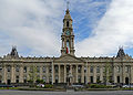
The council met at the South Melbourne Town Hall
on Bank Street between Fishley and Layfield Streets, South Melbourne. The hall still exists and is now used by the Australian National Academy of Music
.
* Estimate in the 1958 Victorian Year Book.
Melbourne
Melbourne is the capital and most populous city in the state of Victoria, and the second most populous city in Australia. The Melbourne City Centre is the hub of the greater metropolitan area and the Census statistical division—of which "Melbourne" is the common name. As of June 2009, the greater...
, the state capital of Victoria
Victoria (Australia)
Victoria is the second most populous state in Australia. Geographically the smallest mainland state, Victoria is bordered by New South Wales, South Australia, and Tasmania on Boundary Islet to the north, west and south respectively....
, Australia
Australia
Australia , officially the Commonwealth of Australia, is a country in the Southern Hemisphere comprising the mainland of the Australian continent, the island of Tasmania, and numerous smaller islands in the Indian and Pacific Oceans. It is the world's sixth-largest country by total area...
, on the south bank of the Yarra River
Yarra River
The Yarra River, originally Birrarung, is a river in east-central Victoria, Australia. The lower stretches of the river is where the city of Melbourne was established in 1835 and today Greater Melbourne dominates and influences the landscape of its lower reaches...
. The city covered an area of 8.91 square kilometres (3.44 sq mi), and existed from 1855 until 1994.
The council area was bounded by the Yarra River
Yarra River
The Yarra River, originally Birrarung, is a river in east-central Victoria, Australia. The lower stretches of the river is where the city of Melbourne was established in 1835 and today Greater Melbourne dominates and influences the landscape of its lower reaches...
to the north, Fraser and Lorne Streets to the south, the Port Phillip
Port Phillip
Port Phillip Port Phillip Port Phillip (also commonly referred to as Port Phillip Bay or (locally) just The Bay, is a large bay in southern Victoria, Australia; it is the location of Melbourne. Geographically, the bay covers and the shore stretches roughly . Although it is extremely shallow for...
foreshore and Pickles Street to the west, and St Kilda Road
St Kilda Road, Melbourne
St Kilda Road is a street in Melbourne, Victoria, Australia. It is part of the locality of Melbourne which has the postcode of 3004 and along with Swanston Street forms a major spine of the city....
to the east.
History
South Melbourne was first incorporated as the Emerald Hill BoroughBorough
A borough is an administrative division in various countries. In principle, the term borough designates a self-governing township although, in practice, official use of the term varies widely....
on 26 May 1855, and became a Town on 1 March 1872. It was proclaimed a City and was renamed to South Melbourne on 21 September 1883.
On 18 November 1993, a small portion around Southbank
Southbank, Victoria
Southbank is an inner city suburb of Melbourne, Victoria, Australia located direct south of the Yarra River opposite Melbourne's Hoddle Grid. The northernmost area is considered part of the Central Business District and Central Activities District of the city. Its Local Government Area are the...
and the Victorian Arts Centre
The Arts Centre (Melbourne)
The Victorian Arts Centre is a performing arts centre consisting of a complex of theatres and concert halls in the Melbourne Arts Precinct, located in the inner Melbourne suburb of Southbank in Victoria, Australia....
was added to the City of Melbourne
City of Melbourne
The City of Melbourne is a Local Government Area in Victoria, Australia, located in the central city area of Melbourne. The city has an area of 36 square kilometres and has an estimated population of 93,105 people. The city's motto is "Vires acquirit eundo" which means "She gathers strength as she...
. On 22 June 1994, the City of South Melbourne was abolished and merged into the newly-created City of Port Phillip
City of Port Phillip
The City of Port Phillip is a Local Government Area in Victoria, Australia. It is located on the northern shores of Port Phillip, south of Melbourne's central business district. It has an area of 20.62 km² and has an estimated population of 96,110 people....
along with the Cities of Port Melbourne
City of Port Melbourne
The City of Port Melbourne was a Local Government Area located about southwest of Melbourne, the state capital of Victoria, Australia, on the south bank of the Yarra River...
and St Kilda
City of St Kilda
The City of St Kilda was a Local Government Area located on Port Phillip about south of Melbourne, the state capital of Victoria, Australia. The city covered an area of , and existed from 1855 until 1994.-History:...
.
The council met at the South Melbourne Town Hall
South Melbourne Town Hall
South Melbourne Town Hall is a civic building located at Bank Place in South Melbourne, a suburb of Melbourne, Australia. It is of state heritage significance to Victoria being listed on the Victorian Heritage Register .-Architecture:...
on Bank Street between Fishley and Layfield Streets, South Melbourne. The hall still exists and is now used by the Australian National Academy of Music
Australian National Academy of Music
The Australian National Academy of Music is Australia's centre of excellence responsible for training the country's finest young musicians. Located in the South Melbourne, Victoria, it is a member of the Australian Roundtable for Arts Training Excellence...
.
Wards
South Melbourne was divided into four wards, each electing three councillors:- Canterbury Ward
- Fawkner Ward
- Hobson Ward
- Queens Ward
Suburbs
- Albert ParkAlbert Park, VictoriaAlbert Park is an inner city suburb of Melbourne, Victoria, Australia, 3 km south from Melbourne's central business district. Its Local Government Area is the City of Port Phillip. At the 2006 Census, Albert Park had a population of 5827....
- MelbourneMelbourne city centreMelbourne City Centre is an area of Melbourne in Victoria, Australia. It is not to be confused with the larger local government area of the City of Melbourne...
(between Queens RoadPrinces HighwayThe Princes Highway extends from Sydney to Port Augusta via the coast through the states of New South Wales, Victoria and South Australia, a distance of 1941 km or 1898 km via the former alignments of the highway ....
and St Kilda RoadSt Kilda Road, MelbourneSt Kilda Road is a street in Melbourne, Victoria, Australia. It is part of the locality of Melbourne which has the postcode of 3004 and along with Swanston Street forms a major spine of the city....
) - Middle ParkMiddle Park, VictoriaMiddle Park is a suburb in Melbourne, Victoria, Australia, 5 km south from Melbourne's central business district. Its Local Government Area is the City of Port Phillip. At the 2006 Census, Middle Park had a population of 4012...
- SouthbankSouthbank, VictoriaSouthbank is an inner city suburb of Melbourne, Victoria, Australia located direct south of the Yarra River opposite Melbourne's Hoddle Grid. The northernmost area is considered part of the Central Business District and Central Activities District of the city. Its Local Government Area are the...
- South MelbourneSouth Melbourne, VictoriaSouth Melbourne is an inner city suburb in Melbourne, Victoria, Australia, 2 km south from Melbourne's central business district. Its Local Government Area are the Cities of Port Phillip and Melbourne...
Population
| Year | Population |
|---|---|
| 1861 | 8,822 |
| 1881 | 25,374 |
| 1891 | 41,724 |
| 1921 | 46,873 |
| 1954 | 37,955 |
| 1958 | 35,300* |
| 1961 | 32,528 |
| 1966 | 30,174 |
| 1971 | 26,995 |
| 1976 | 21,334 |
| 1981 | 19,955 |
| 1986 | 18,499 |
| 1991 | 17,712 |
* Estimate in the 1958 Victorian Year Book.