

City of Caloundra
Encyclopedia
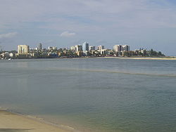
The City of Caloundra was a Local Government Area located about 90 kilometres (56 mi) north of Brisbane
in the Sunshine Coast
region of South East
Queensland
, Australia
. The shire covered an area of 1093.1 square kilometres (422 sq mi), and existed as a local government entity from 1912 until 2008, when it amalgamated with councils further north to form the Sunshine Coast Region.
The City covered the urban localities of Caloundra and Kawana
and surrounding suburbs, the northern half of Bribie Island and the western hinterland towns of Landsborough
, Maleny
and Witta.
wood. The area was originally incorporated as part of the Caboolture Division
on 11 November 1879 under the Divisional Boards Act 1879. With the passage of the Local Authorities Act 1902, Caboolture became a shire on 31 March 1903.
On 22 February 1912, the Shire of Landsborough split away and was proclaimed in its own right. John Tytherleigh, a local businessman with stores in the area, was elected its first chairman and they quickly set to work building a Shire Chambers in Landsborough
. It was reconstructed from local timbers under the guidance of architect Walter Voller in 1924, and the building is today used as a museum housing artifacts including former Premier Frank Nicklin
's personal collection.
On 19 December 1987, the Shire was granted City status, and was renamed the City of Caloundra, reflecting the population boom in the coastal section of the City. The Council Chambers were relocated to Omrah Avenue, Caloundra
, and Jack Beausang, the long-serving Chairman of the Shire of Landsborough, was sworn in as its first Mayor. He retired undefeated on 17 March 1988, and Don Aldous was elected to replace him.
 On 15 March 2008, under the Local Government (Reform Implementation) Act 2007 passed by the Parliament of Queensland
on 10 August 2007, the City of Caloundra merged with the Shire of Noosa and the Shire of Maroochy to form the Sunshine Coast Region.
* Split with Shire of Maroochy
Brisbane
Brisbane is the capital and most populous city in the Australian state of Queensland and the third most populous city in Australia. Brisbane's metropolitan area has a population of over 2 million, and the South East Queensland urban conurbation, centred around Brisbane, encompasses a population of...
in the Sunshine Coast
Sunshine Coast, Queensland
The Sunshine Coast is an urban area in South East Queensland, north of the state capital of Brisbane on the Pacific Ocean coastline. Although it does not have a central business district, by population it ranks as the 10th largest metropolis in Australia and the third largest in...
region of South East
South East Queensland
South East Queensland is a region of the state of Queensland in Australia, which contains approximately two-thirds of the state population...
Queensland
Queensland
Queensland is a state of Australia, occupying the north-eastern section of the mainland continent. It is bordered by the Northern Territory, South Australia and New South Wales to the west, south-west and south respectively. To the east, Queensland is bordered by the Coral Sea and Pacific Ocean...
, Australia
Australia
Australia , officially the Commonwealth of Australia, is a country in the Southern Hemisphere comprising the mainland of the Australian continent, the island of Tasmania, and numerous smaller islands in the Indian and Pacific Oceans. It is the world's sixth-largest country by total area...
. The shire covered an area of 1093.1 square kilometres (422 sq mi), and existed as a local government entity from 1912 until 2008, when it amalgamated with councils further north to form the Sunshine Coast Region.
The City covered the urban localities of Caloundra and Kawana
Kawana, Queensland
Kawana is an urban centre on the Sunshine Coast in Queensland, Australia, between Caloundra and Maroochydore along the Coral Sea coast. The suburbs are connected by the Nicklin Way arterial road....
and surrounding suburbs, the northern half of Bribie Island and the western hinterland towns of Landsborough
Landsborough, Queensland
Landsborough is a small town on the Sunshine Coast hinterland of Queensland, Australia. It is situated north of the Glasshouse Mountains just off Steve Irwin Way, 82 km north of Brisbane...
, Maleny
Maleny, Queensland
Maleny is a small, scenic town north of Brisbane on the Blackall Range overlooking the Sunshine Coast hinterland in Queensland, Australia. Nearby towns include Landsborough, Montville and Peachester...
and Witta.
History
In 1868, the Queensland Government opened up large areas of land for settlement in the Caloundra area which became home to pioneers and timber cutters seeking red cedarToona ciliata
Australian Red Cedar , Toona ciliata is a forest tree in the family Meliaceae which grows throughout southern Asia from Afghanistan to Papua New Guinea and Australia. In Australia its natural habitat is now extensively cleared subtropical rainforests of New South Wales and Queensland...
wood. The area was originally incorporated as part of the Caboolture Division
Shire of Caboolture
The Shire of Caboolture was a Local Government Area located in the Australian state of Queensland on the northern urban fringe of the capital, Brisbane, and south of the Sunshine Coast...
on 11 November 1879 under the Divisional Boards Act 1879. With the passage of the Local Authorities Act 1902, Caboolture became a shire on 31 March 1903.
On 22 February 1912, the Shire of Landsborough split away and was proclaimed in its own right. John Tytherleigh, a local businessman with stores in the area, was elected its first chairman and they quickly set to work building a Shire Chambers in Landsborough
Landsborough, Queensland
Landsborough is a small town on the Sunshine Coast hinterland of Queensland, Australia. It is situated north of the Glasshouse Mountains just off Steve Irwin Way, 82 km north of Brisbane...
. It was reconstructed from local timbers under the guidance of architect Walter Voller in 1924, and the building is today used as a museum housing artifacts including former Premier Frank Nicklin
Frank Nicklin
Sir George Francis Reuben Nicklin, KCMG, MM was Premier of the Australian state of Queensland from 1957 to 1968, and the first Country Party Premier since 1932.-Early life and career:...
's personal collection.
On 19 December 1987, the Shire was granted City status, and was renamed the City of Caloundra, reflecting the population boom in the coastal section of the City. The Council Chambers were relocated to Omrah Avenue, Caloundra
Caloundra (suburb)
Caloundra is a suburb of the Sunshine Coast, Queensland, Australia, and includes the central business district of the Caloundra urban centre, which is located on Bulcock Street.-Education:Caloundra contains the following schools within its boundaries:...
, and Jack Beausang, the long-serving Chairman of the Shire of Landsborough, was sworn in as its first Mayor. He retired undefeated on 17 March 1988, and Don Aldous was elected to replace him.
Parliament of Queensland
The Parliament of Queensland is the legislature of Queensland, Australia. According to the state's constitution, the Parliament consists of the Queen and the Legislative Assembly. It is the only unicameral state parliament in the country, the upper chamber, the Legislative Council, having been...
on 10 August 2007, the City of Caloundra merged with the Shire of Noosa and the Shire of Maroochy to form the Sunshine Coast Region.
Structure
The Shire was subdivided into 10 numbered divisions, each of which returned one councillor, and an elected mayor.Towns and localities
|
Coochin Creek, Queensland Coochin Creek is a locality in the southern hinterland region of the Sunshine Coast, Queensland, Australia. Almost all of the locality's area is part of the Beerburrum State Forest.... Currimundi, Queensland Currimundi is a suburb of the Sunshine Coast, Queensland, Australia, located within the Caloundra urban centre north of Caloundra.It was named by Sir Leslie Wilson, in which he used the local aboriginal name for the area, Garrimundi or Girrimundi, meaning Place of flying foxes.Currimundi Lake is a... Dicky Beach, Queensland Dicky Beach is a suburb of the Sunshine Coast, Queensland, Australia, located within the Caloundra urban centre.The area was named after the iron steamboat, the SS Dicky, which ran aground during heavy seas in 1893. It was re-floated, but again, heavy seas turned the ship about and back onto the... Glass House Mountains, Queensland Glass House Mountains is a hinterland town of the Sunshine Coast, Queensland, Australia, named after the famous Glass House Mountains of the area. It is located approximately 64 km north of Brisbane, belonging to the Sunshine Coast Regional Council local government area . Colloquially it is... Glenview, Queensland Glenview is a small town on the Sunshine Coast in Queensland, Australia. Its Local Government Area is the Sunshine Coast Regional Council.The Aussie World family park is located in the town, and part of the Ewen Maddock Dam is in the area.-References:... Golden Beach, Queensland Golden Beach is a suburb of the Sunshine Coast, Queensland, Australia, located within the Caloundra urban centre directly southwest of the Caloundra CBD.-History:... Kings Beach, Queensland Kings Beach is a suburb of the Sunshine Coast, Queensland, Australia, located within the Caloundra urban centre directly east of Caloundra CBD.Kings Beach was named after the King family, the first residents in the area... Landsborough, Queensland Landsborough is a small town on the Sunshine Coast hinterland of Queensland, Australia. It is situated north of the Glasshouse Mountains just off Steve Irwin Way, 82 km north of Brisbane... Little Mountain, Queensland Little Mountain is a suburb of the Sunshine Coast, Queensland, Australia, located within the Caloundra urban centre west of Caloundra CBD.The Corbould Park racecourse is located in the suburb, as well as the Caloundra Pony Club and Sunshine Coast Clay Targer club.... Maleny, Queensland Maleny is a small, scenic town north of Brisbane on the Blackall Range overlooking the Sunshine Coast hinterland in Queensland, Australia. Nearby towns include Landsborough, Montville and Peachester... |
Meridan Plains, Queensland Meridan Plains is a suburb of the Sunshine Coast, Queensland, Australia, located partly within the Caloundra urban centre west-northwest of Caloundra.... Minyama, Queensland Minyama is a suburb of the Sunshine Coast, Queensland, Australia, located within the Kawana urban centre. Situated on the Mooloolah River, the suburb is almost entirely surrounded by water, and artificially constructed harbours and waterways dominate the topography. The suburb's main thoroughfare,... Moffat Beach, Queensland Moffat Beach is a suburb of the Sunshine Coast, Queensland, Australia, located within the Caloundra urban centre directly north-east of Caloundra CBD.... Palmview, Queensland Palmview is a suburb in the Sunshine Coast, Queensland, Australia. It is home to Aussie World and the Ettamogah Pub.-External links:*... Parrearra, Queensland Parrearra is a suburb of the Sunshine Coast, Queensland, Australia, located within the Kawana urban centre. It contains the locality of Kawana Island.-External links:*... Peachester, Queensland Peachester is a small town in the Sunshine Coast hinterland of Queensland, Australia. At the 2006 census, Peachester had a population of 452.-External links:*... Pelican Waters, Queensland Pelican Waters is a suburb of the Sunshine Coast, Queensland, Australia, located within the Caloundra urban centre southwest of Caloundra CBD.... Shelly Beach, Queensland Shelly Beach is a suburb of the Sunshine Coast, Queensland, Australia, located within the Caloundra urban centre.-External links:*... Warana, Queensland Warana is a suburb of the Sunshine Coast, Queensland, Australia, located within the Kawana urban centre.-External links:*... Wurtulla, Queensland Wurtulla is a suburb of the Sunshine Coast, Queensland, Australia, located within the Kawana urban centre. The name means "southward" in the local Aboriginal language, and it was named by Kawana Estates employees in the 1970s.-External links:*... |
Population
| Year | Population |
|---|---|
| 1933 | 4,752 |
| 1947 | 6,460 |
| 1954 | 7,765 |
| 1961 | 8,319 |
| 1966 | 8,798 |
| 1971 | 11,314 |
| 1976 | 16,982 |
| 1981 | 29,705 |
| 1986 | 36,486 |
| 1991 | 53,434 |
| 1996 | 66,336 |
| 2001 | 75,261 |
| 2006 | 90,341 |
Mayors
- Don Aldous (1988–2008)
- Jack Beausang (1964–1988)
- H.W. Anning (1958–1961)
- A. Fleming (1949–1958)
- H.M. Bray (1933–1949)
External links
- Caloundra Queensland - a Wikitravel article