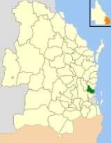
Shire of Caboolture
Encyclopedia
The Shire of Caboolture was a Local Government Area located in the Australia
Australia
Australia , officially the Commonwealth of Australia, is a country in the Southern Hemisphere comprising the mainland of the Australian continent, the island of Tasmania, and numerous smaller islands in the Indian and Pacific Oceans. It is the world's sixth-largest country by total area...

n state of Queensland
Queensland
Queensland is a state of Australia, occupying the north-eastern section of the mainland continent. It is bordered by the Northern Territory, South Australia and New South Wales to the west, south-west and south respectively. To the east, Queensland is bordered by the Coral Sea and Pacific Ocean...

 on the northern urban fringe of the capital, Brisbane
Brisbane
Brisbane is the capital and most populous city in the Australian state of Queensland and the third most populous city in Australia. Brisbane's metropolitan area has a population of over 2 million, and the South East Queensland urban conurbation, centred around Brisbane, encompasses a population of...

, and south of the Sunshine Coast
Sunshine Coast, Queensland
The Sunshine Coast is an urban area in South East Queensland, north of the state capital of Brisbane on the Pacific Ocean coastline. Although it does not have a central business district, by population it ranks as the 10th largest metropolis in Australia and the third largest in...

. The shire covered an area of 1224.4 square kilometres (472.7 sq mi), of which approximately one-quarter was urban, and existed as a local government entity from 1879 until 2008, when it amalgamated with the City of Redcliffe
City of Redcliffe
City of Redcliffe is a defunct Local Government Area in South East Queensland, Australia. It is in the northern part of the County of Stanley. The council covers the suburbs of Clontarf, Kippa-Ring, Margate, Redcliffe, Rothwell, Scarborough and Woody Point – a total area of 38.1 km² with a...

 and Shire of Pine Rivers to form the Moreton Bay Region.

History

Caboolture Division was created on 11 November 1879 as one of 74 divisions around Queensland under the Divisional Boards Act 1879. It was centred on Caboolture
Caboolture, Queensland
Caboolture is an urban centre approximately north of Brisbane, the state capital of Queensland, Australia. Caboolture is considered to be the northernmost urban area of the greater Brisbane metropolitan region within South East Queensland, and it marks the end of the Brisbane suburban commuter...

, which was at that time a small logging town, and initially covered all of Moreton Bay and much of the Sunshine Coast
Sunshine Coast, Queensland
The Sunshine Coast is an urban area in South East Queensland, north of the state capital of Brisbane on the Pacific Ocean coastline. Although it does not have a central business district, by population it ranks as the 10th largest metropolis in Australia and the third largest in...

, but by 1890 had shrunk considerably with the separate incorporation of the Pine Division (21 January 1888), Redcliffe Division (5 April 1888) and Maroochy Division (5 July 1890). Caboolture became a Shire on 31 March 1903 after the Local Authorities Act 1902 was enacted.

On 15 March 2008, under the Local Government (Reform Implementation) Act 2007 passed by the Parliament of Queensland
Parliament of Queensland
The Parliament of Queensland is the legislature of Queensland, Australia. According to the state's constitution, the Parliament consists of the Queen and the Legislative Assembly. It is the only unicameral state parliament in the country, the upper chamber, the Legislative Council, having been...

 on 10 August 2007, the Shire of Caboolture merged with the City of Redcliffe
City of Redcliffe
City of Redcliffe is a defunct Local Government Area in South East Queensland, Australia. It is in the northern part of the County of Stanley. The council covers the suburbs of Clontarf, Kippa-Ring, Margate, Redcliffe, Rothwell, Scarborough and Woody Point – a total area of 38.1 km² with a...

 and the Shire of Pine Rivers to form the Moreton Bay Region.

Suburbs and towns


Coastal region:
  • Beachmere
    Beachmere, Queensland
    Beachmere is a suburb north of Brisbane, the state capital of Queensland, Australia. Its Local Government Area is the Moreton Bay Region with a population of 3,597 ....

  • Bellmere
    Bellmere, Queensland
    Bellmere is a suburb of the Moreton Bay Region in Queensland, Australia. Located to the west of the centre of Caboolture, it is essentially a suburb of that town. At the 2006 census, the suburb recorded a population of 2,406 persons, with a median age of 35 years..-External links:* Live weather...

  • Burpengary
    Burpengary, Queensland
    Burpengary is a suburb 35 kilometres from the Brisbane CBD, in Queensland, Australia. Its Local Government Area is the Moreton Bay Region.The name is derived from the Aboriginal word burpengar, meaning the "land of the golden wattle"....

  • Caboolture
    Caboolture, Queensland
    Caboolture is an urban centre approximately north of Brisbane, the state capital of Queensland, Australia. Caboolture is considered to be the northernmost urban area of the greater Brisbane metropolitan region within South East Queensland, and it marks the end of the Brisbane suburban commuter...

  • Caboolture South
    Caboolture South, Queensland
    Caboolture South is a suburb 45 kilometres north north of Brisbane, the state capital of Queensland, Australia. Its Local Government Area is the Moreton Bay Region....

  • Deception Bay
    Deception Bay, Queensland
    Deception Bay is a suburb north of Brisbane, Queensland, Australia. Its Local Government Area is the Moreton Bay Region and is located approximately 32 km north of Brisbane in the south-eastern corner of the bay of the same name which separates the Redcliffe peninsula and Bribie...

  • Donnybrook
    Donnybrook, Queensland
    Donnybrook is a small village 60 km north of Brisbane, the state capital of Queensland, Australia. At the 2006 census, Donnybrook had a population of 456.It started out as a small fishing community but has since developed into a minor tourist destination...

  • Elimbah
    Elimbah, Queensland
    Elimbah is a suburb of the Moreton Bay Region in Queensland, Australia. It is located north of the larger centre of Caboolture, and south of Beerburrum. At the 2006 census, the suburb recorded a population of 648 persons, with a median age of 36 years....

  • Godwin Beach
  • Meldale
  • Moodlu
  • Morayfield
  • Narangba
    Narangba, Queensland
    Narangba is a suburb north of Brisbane, Queensland, Australia. It is located in the Moreton Bay Region.This suburb has rural origins, but is being redeveloped as a residential suburb on the outskirts of the greater Brisbane metropolitan area.-History:...

  • Ningi
    Ningi, Queensland
    Ningi is a suburb north of Brisbane, the state capital of Queensland, Australia.The origin of the suburb name is from the Aboriginal Ningi Ningi group....

  • Sandstone Point
    Sandstone Point, Queensland
    Sandstone Point is a suburb approximately north of Brisbane within the Moreton Bay Region. It is located across the bridge from Bribie Island and has views of Moreton Bay and surroundings. The suburb is one of the fastest growing residential communities in the Moreton Bay Regional Council...

  • Toorbul
  • Upper Caboolture

Inland region:
  • Bellthorpe
  • Booroobin
  • Bracalba
  • Campbells Pocket
  • Cedarton
  • Commissioners Flat
  • D'Aguilar
    D'Aguilar, Queensland
    D'Aguilar is a rural township in Queensland, Australia. Located northwest of the larger centre of Caboolture, it is located within the Moreton Bay Region. At the 2006 census, the locality recorded a population of 1,094 persons, living in 373 inhabited dwellings, all of which were detached...

  • Delaneys Creek
    Delaneys Creek, Queensland
    Delaneys Creek is a rural suburb in Queensland, Australia. Located south of D'Aguilar, it is located within the Moreton Bay Region. At the 2006 census, the locality recorded a population of 495 persons, living in 163 detached houses and five 'other' dwellings...

  • Moorina
  • Mount Delaney
  • Mount Mee
    Mount Mee, Queensland
    Mount Mee is a suburb and mountain in Queensland, Australia, located north of the town of Dayboro on the D'Aguilar Range.-History:The area around Mount Mee was known to the indigenous inhabitants of the area as Dahmongah, a word meaning "flying squirrel" or glider...

  • Neurum
  • Rocksberg
  • Stanmore
  • Stony Creek
  • Wamuran
    Wamuran, Queensland
    Wamuran is a suburb of the Moreton Bay Region in Queensland, Australia. It is located west of the larger centre of Caboolture, and southeast of D'Aguilar. At the 2006 census, the suburb recorded a population of 2,086 persons, with a median age of 37 years. Wamuran is known for its fresh...

  • Wamuran Basin
    Wamuran Basin, Queensland
    Wamuran Basin is a suburb of the Moreton Bay Region in Queensland, Australia. At the 2006 census, the suburb recorded a population of 245 persons, with a median age of 47 years.....

  • Woodford
    Woodford, Queensland
    Woodford is a small town in Queensland, Australia, on the D'Aguilar Highway 72 km north-west of Brisbane and 24 km west of Caboolture. Its Local Government Area is the Moreton Bay Region. The town is noted for its folk festival that takes place over the New Year holidays. The Woodford...


Bribie Island:
  • Banksia Beach
    Banksia Beach, Queensland
    Banksia Beach is a suburb on Bribie Island, approximately 49 km north of Brisbane, the state capital of Queensland, Australia. Its Local Government Area is Moreton Bay RegionThe name refers to the plant genus banksia, which grows in the area....

  • Bellara
    Bellara, Queensland
    Bellara is a suburb of the Moreton Bay Region in Queensland, Australia. It is located on the western side of Bribie Island, adjacent to the Pumicestone Passage. At the 2006 census, the suburb recorded a population of 2,962 persons, with a median age of 51 years.....

  • Bongaree
    Bongaree, Queensland
    Bongaree is a suburb of the Moreton Bay Region in Queensland, Australia. It is located on the western side of Bribie Island, adjacent to the Pumicestone Passage. At the 2006 census, the suburb recorded a population of 14,275 persons, with a median age of 55 years..The suburb is named after the...

  • Bribie Island NP
    Bribie Island National Park
    Bribie Island is a national park in Queensland, Australia, 68 km north of Brisbane. The park covers approximately one third of Bribie Island...

  • Welsby
  • White Patch
  • Woorim
    Woorim, Queensland
    Woorim is a suburb of the Moreton Bay Region in Queensland, Australia. It is located on the eastern or ocean side of Bribie Island, adjacent to the Pacific Ocean. At the 2006 census, the suburb recorded a population of 1,638 persons, with a median age of 53 years..Woorim is the location of the...


Population

Year Population % Annual
Growth
1933 5,316
1947 5,716
1954 7,101 3.15
1961 8,877 3.24
1966 10,149 2.71
1971 12,207 3.76
1976 19,404 9.71
1981 32,644 10.96
1986 47,494 7.79
1991 70,052 8.08
1996 98,859 7.13
2001 112,458 2.61
2006 132,473 3.33

External links

The source of this article is wikipedia, the free encyclopedia.  The text of this article is licensed under the GFDL.
 
x
OK