

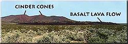
Cinder Cone National Natural Landmark
Encyclopedia
Mojave National Preserve
Mojave National Preserve is located in the Mojave Desert of San Bernardino County, California, USA, between Interstate 15 and Interstate 40. The preserve was established October 31, 1994 with the passage of the California Desert Protection Act by the US Congress...
in southeastern California
California
California is a state located on the West Coast of the United States. It is by far the most populous U.S. state, and the third-largest by land area...
in the United States
United States
The United States of America is a federal constitutional republic comprising fifty states and a federal district...
. The landmark is located mostly south of Interstate 15
Interstate 15 in California
In the U.S. state of California, Interstate 15 is a major north–south route through the San Bernardino, Riverside, and San Diego Counties, and it has a length of in the state. It is a major thoroughfare for traffic between Southern California and Las Vegas, Nevada, as well as points beyond...
and the small community of Halloran Springs
Halloran Springs, California
Halloran Springs is an unincorporated community in San Bernardino County, California, USA. It lies at in the Mojave Desert approximately 15 miles northeast of Baker, California on Interstate 15 between Baker and Las Vegas, Nevada....
. The cinder cone
Cinder cone
According to the , Cinder Cone is the proper name of 1 cinder cone in Canada and 7 cinder cones in the United States:In Canada: Cinder Cone In the United States:...
s were formed when lava
Lava
Lava refers both to molten rock expelled by a volcano during an eruption and the resulting rock after solidification and cooling. This molten rock is formed in the interior of some planets, including Earth, and some of their satellites. When first erupted from a volcanic vent, lava is a liquid at...
erupted. Most of the cinder cones and lava flows lie between Kelbaker Road on the west and Cima Road to the east.